1940s Maps of Los Angeles, California
Explore 24 historic maps of Los Angeles from the 1940s. These maps offer a rare glimpse into what life looked like during the 1940s — showing old roads, neighborhoods, homes, and landmarks that have changed or disappeared over time.
Whether you're researching your family's past, planning a metal detecting trip, or studying how Los Angeles's landscape evolved across the 1940s, these high-resolution maps are a powerful tool for exploring the history of this region.
- Focus on a specific era: All maps on this page are from the 1940s, giving you a focused view of this time period.
- See what’s changed: Compare century-old streets, trails, and buildings to today's modern landscape using overlays and satellite layers.
- Research with precision: Use these maps for genealogy, historical research, land use analysis, or educational projects.
- View, download, or print: Maps are fully viewable online in high resolution, and can be downloaded or printed for your own records.
Start exploring Los Angeles's history through authentic maps from the 1940s. This is your window into the past.
Los Angeles, CA maps
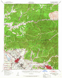
(24)- 1940 Map of Chatsworth
 1940 Chatsworth1940 Print · USGSThe northwest San Fernando Valley appears in the 1940s as a land of iconic movie ranches and burgeoning citrus communities. Researchers can trace the early footprints of Chatsworth and Canoga Park or locate family-named sites like Iverson Ranch and Brandies Ranch.
 - 1940 Map of San Fernando, 1955 Print
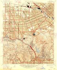
 1940 San Fernando1955 Print · USGSThe northern Los Angeles basin is shown here just before the postwar housing boom, as the valley floor transitioned from rural estates to suburban centers. Genealogists can trace family footprints near the San Fernando Mission or follow the rail lines through Solemint and Sylmar.2 unique versions available
 - 1940 Map of Acton, 1955 Print
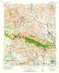
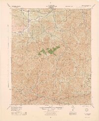
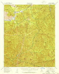 1940 Acton1955 Print · USGSThe high canyons of the San Gabriel Mountains are captured here during the 1940s, showing the early reach of water infrastructure and mining in the region. Genealogists and historians can trace the Southern Pacific rail line through Acton and Ravenna, or locate remote sites like the Monte Cristo Mine.
 - 1941 Map of Zelzah
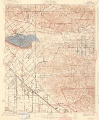
 1941 Zelzah1941 Print · USGSThe San Fernando Valley is seen here in a pivotal pre-war era of agricultural colonies and early suburban plats. Researchers can trace the layout of the Runnymede Poultry Colony, the transition at Zelzah Northridge PO and Sta, and legacy holdings like Marwyck Ranch.2 unique versions available
 - 1941 Map of Las Bolsas, 1961 Print
 1941 Las Bolsas1961 Print · USGSCoastal Orange County appears at the brink of the war years, showing a shoreline defined by marshlands and early beach communities. Genealogists and local historians can trace the Pacific Electric line and explore landmarks like the Bolsa Chica Gun Club and Meadow Lark Country Club Sch.2 unique versions available
 - 1941 Map of Santa Susana, 1964 Print
 1941 Santa Susana1964 Print · USGSVentura and Los Angeles counties meet in this 1940s landscape of steep canyons and early oil development. Researchers can trace the ranching history of Brandeis Ranch and Iverson Ranch or locate industrial sites like the Newhall-Potrero Oil Field.2 unique versions available
 - 1942 Map of Downey
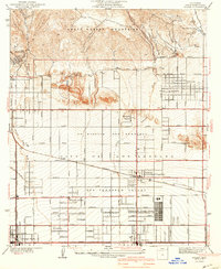
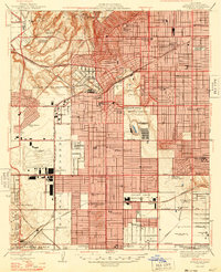
 1942 Downey1942 Print · USGSThe Los Angeles Basin and North Orange County appear here during the wartime boom, showcasing a landscape transitioning from ranchos to suburbs. Trace the historic Pacific Electric rail lines, the oil fields of Santa Fe Springs, and early settlements like Hynes and Studebaker.
 - 1942 Map of San Pedro Hill
 1942 San Pedro Hill1942 Print · USGSThe Palos Verdes Peninsula was just beginning its modern expansion in the early 1940s, balancing coastal estates with early industrial grids. Trace the development of Palos Verdes Estates, locate the Whites Point Hot Springs, or study the early layout of Lomita.
 - 1942 Map of Sunland
 1942 Sunland1942 Print · USGSThe northeastern San Fernando Valley is captured here just as the aviation industry was transforming the landscape during the early 1940s. Genealogists and local historians can trace early neighborhood footprints in Roscoe and Sunland, or locate landmarks like Adams Airport and the Hansen Flood Control Basin.3 unique versions available
 - 1943 Map of Santa Susana
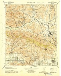 1943 Santa Susana1943 Print · USGSSouthern California ranching and oil industries intersect in the early 1940s along the Santa Susana Mountains. Trace historic boundaries and sites like Tapo Ranch, the Newhall-Potrero Oil Field, and the Southern Pacific rail line.
 - 1943 Map of Las Bolsas
 1943 Las Bolsas1943 Print · USGSThe Orange County coast and wetlands come into focus during the early 1940s as agricultural grids meet the sea. Local historians can trace the early rail influence of the Pacific Electric and locate old landmarks like the Springdale Sch or Wintersburg.
 - 1943 Map of San Pedro
 1943 San Pedro1943 Print · USGSThe South Bay and Los Angeles Harbor area appear here during the Second World War, showing a landscape of burgeoning industry and aviation. Trace wartime infrastructure and local landmarks like Hughes Airport, Terminal Island, and Inglewood Park Cem.
 - 1943 Map of Downey, 1963 Print
 1943 Downey1963 Print · USGSSoutheast Los Angeles County and northern Orange County appear here at the height of the mid-century boom. Researchers can trace the massive rail infrastructure of the Pacific Electric and locate landmarks like the County Hospital and Signal Hill.2 unique versions available
 - 1944 Map of Tujunga
 1944 Tujunga1944 Print · USGSThe high canyons and desert fringes of the San Gabriel Mountains are captured here during the mid-forties. Genealogists and historians can trace the Southern Pacific rail line through Acton or locate the historic Monte Cristo Mines and the Tujunga Dam.
 - 1944 Map of Calabasas
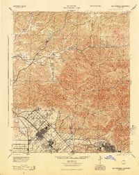
 1944 Calabasas1944 Print · USGSMid-century Los Angeles County unfolds here, showing the grid of the San Fernando Valley meeting the Santa Monica Mountains. Trace old ranch boundaries at Platt Ranch or locate early landmarks like the Will Rogers Memorial and Topanga Lookout.
 - 1944 Map of San Pedro
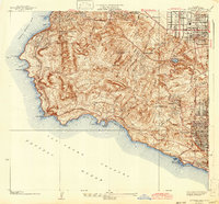
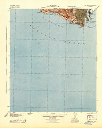 1944 San Pedro1944 Print · USGSCoastal California at the height of the war reveals a landscape of strategic defense and maritime industry. Researchers can trace the military boundaries of Fort Mac Arthur and find coastal landmarks like Point Fermin and Abalone Cove.
 - 1944 Map of Redondo
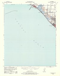
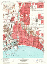
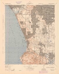 1944 Redondo1944 Print · USGSCoastal Los Angeles at the height of the Second World War shows a landscape defined by expanding refineries, rail lines, and beach towns. Genealogists and historians can trace the foundations of South Bay industry through the Standard Oil Co Refinery, Inglewood Park Cemetery, and the early Pacific Electric routes.
 - 1945 Map of San Fernando
 1945 San Fernando1945 Print · USGSThe northern reaches of Los Angeles County appear in the mid-1940s, just as suburban growth began to meet the steep canyon walls. Researchers can trace the path of the Southern Pacific through the mountain passes or locate landmarks like the San Fernando Mission and Sunland.
 - 1948 Map of Burbank
 1948 Burbank1948 Print · USGSBurbank and North Hollywood entered a period of massive post-war growth as the film and aerospace industries reshaped the valley. Trace the early footprints of the Walt Disney Studio, Universal Studio, and the Lockheed Air Terminal during this formative era.
 - 1948 Map of Inglewood
 1948 Inglewood1948 Print · USGSPostwar Los Angeles undergoes a massive industrial and suburban shift in the late 1940s as aviation manufacturing centers expand. Trace early footprints of Los Angeles Airport and iconic sites like Hollywood Park or the Pacific Electric lines.
 - 1949 Map of Los Angeles
 1949 Los Angeles1949 Print · USGSSouthern California and the South Coast appear at the onset of the post-war boom, from the Channel Islands to the Mojave Desert. Trace early aviation sites like Lockheed Air Terminal and mining history at the Redrock Quicksilver Mine and Redrover Mine.2 unique versions available
 - 1949 Map of Long Beach
 1949 Long Beach1949 Print · USGSSouthern California at the start of the post-war boom shows the rapid development of the Los Angeles basin and the South Bay. Genealogists and historians can trace the evolution of early suburbs like Gardena and Lynwood or the coastal defenses at Ft MacArthur Lower Reservation.2 unique versions available
 - 1949 Map of Long Beach, 1951 Print
 1949 Long Beach1951 Print · USGSLong Beach and its coastal neighbors are captured here during a period of massive post-war growth and industrial production. Genealogists and historians can trace neighborhood landmarks like Polytechnic High Sch, the landmarks of Signal Hill, and the historic Rainbow Pier.4 unique versions available
 - 1949 Map of South Gate, 1957 Print
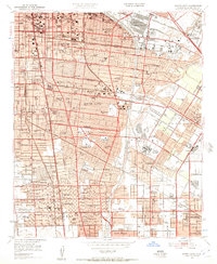 1949 South Gate1957 Print · USGSSoutheast Los Angeles at the end of the 1940s reveals a thriving hub of rail, aviation, and industry during its post-war growth spurt. Genealogists and historians can trace family-named sites like Rancho Los Amigos and the Russian Molokan Cem alongside defunct airfields like Vail Airport.2 unique versions available
End of results
Showing maps 1-24 of 24
Top cities near Los Angeles
- Long Beach historical maps
- Glendale historical maps
- Torrance historical maps
- Pasadena historical maps
- Simi Valley historical maps
- Inglewood historical maps
See more
Top neighborhoods of Los Angeles
- Pacific Palisades historical maps
- Harbor Pines historical maps
- Dana Strand Village historical maps
- Los Angeles Eco Village historical maps
- Thenard historical maps
- Studio City Neighborhood Council District historical maps
See more
Frequently asked questions
- What are the different types of historical maps available for Los Angeles?
- What is the oldest map of Los Angeles?
- Where can I purchase historical maps of Los Angeles for my home or office?
- Where can I download high-res historical maps of Los Angeles?
- Are there historical topographic maps available for Los Angeles?
- Is there historical aerial imagery available for Los Angeles?
- Where are historical maps of Los Angeles sourced from?