1990s Maps of Los Angeles, California
Explore 7 historic maps of Los Angeles from the 1990s. These maps offer a rare glimpse into what life looked like during the 1990s — showing old roads, neighborhoods, homes, and landmarks that have changed or disappeared over time.
Whether you're researching your family's past, planning a metal detecting trip, or studying how Los Angeles's landscape evolved across the 1990s, these high-resolution maps are a powerful tool for exploring the history of this region.
- Focus on a specific era: All maps on this page are from the 1990s, giving you a focused view of this time period.
- See what’s changed: Compare century-old streets, trails, and buildings to today's modern landscape using overlays and satellite layers.
- Research with precision: Use these maps for genealogy, historical research, land use analysis, or educational projects.
- View, download, or print: Maps are fully viewable online in high resolution, and can be downloaded or printed for your own records.
Start exploring Los Angeles's history through authentic maps from the 1990s. This is your window into the past.
Los Angeles, CA maps
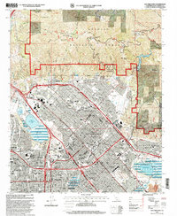
(7)- 1991 Map of Sunland, 1995 Print
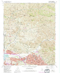 1991 Sunland1995 Print · USGSThe San Fernando Valley meets the mountains in the early nineties as residential neighborhoods push against the Angeles National Forest. Local historians can trace institutional sites like the Lakeview Terrace Sanitarium, Verdugo Hills Cem, and Karl Holton Camp.
 - 1991 Map of Topanga, 1995 Print
 1991 Topanga1995 Print · USGSCoastal Los Angeles meets the steep Santa Monica Mountains in the early nineties, where dense seaside neighborhoods contrast with rugged canyon life. Local historians can trace the foundations of Pacific Palisades or locate landmarks like Trippet Ranch and Camp Josepho.2 unique versions available
 - 1995 Map of Pasadena, 1999 Print
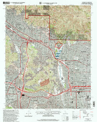 1995 Pasadena1999 Print · USGSThe San Gabriel Valley is captured in the mid-nineties as the urban sprawl of Pasadena and Glendale meets the southern canyons of the Angeles National Forest. Researchers can trace institutional landmarks like the Jet Propulsion Laboratory and the historic Rose Bowl.
 - 1995 Map of Beverly Hills, 1999 Print
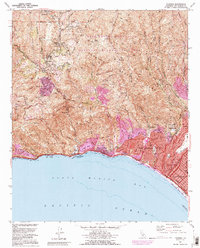
 1995 Beverly Hills1999 Print · USGSBeverly Hills and the Westside of Los Angeles appear in detail during the late nineties, from the canyons of the Santa Monica Mountains to the coast. Researchers can trace the development of iconic sites like the UCLA campus, MGM Studios, and the Santa Monica Pier.2 unique versions available
 - 1995 Map of San Fernando, 1999 Print
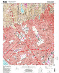
 1995 San Fernando1999 Print · USGSThe San Fernando Valley at the end of the century shows a dense suburban landscape pushing against the foothills of the Angeles National Forest. Researchers can trace local heritage through landmarks like Pioneer Memorial Cem, the San Fernando Valley Juvenile Hall, and Whiteman Air Park.
 - 1995 Map of Sunland, 1999 Print
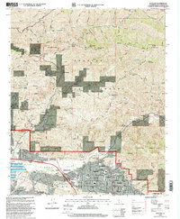 1995 Sunland1999 Print · USGSThe foothills of the San Gabriel Mountains meet the San Fernando Valley during the mid-nineties in this detailed survey of the Los Angeles edge. Trace local history through the Lakeview Terrace Sanitarium, Verdugo Hills Cem, and the canyons of Angeles National Forest.
 - 1995 Map of Condor Peak, 1999 Print
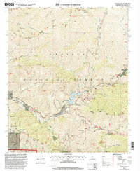 1995 Condor Peak1999 Print · USGSThe northern reaches of Los Angeles are mapped during the mid-nineties as suburban growth pressed against the steep canyons of the San Gabriel Mountains. Researchers can locate the Big Tujunga Dam, the historic Ybarra Ranch, and remote sites like the Lodestone Mine.
End of results
Showing maps 1-7 of 7
Top cities near Los Angeles
- Long Beach historical maps
- Glendale historical maps
- Torrance historical maps
- Pasadena historical maps
- Simi Valley historical maps
- Inglewood historical maps
See more
Top neighborhoods of Los Angeles
- Pacific Palisades historical maps
- Harbor Pines historical maps
- Dana Strand Village historical maps
- Los Angeles Eco Village historical maps
- Thenard historical maps
- Studio City Neighborhood Council District historical maps
See more
Frequently asked questions
- What are the different types of historical maps available for Los Angeles?
- What is the oldest map of Los Angeles?
- Where can I purchase historical maps of Los Angeles for my home or office?
- Where can I download high-res historical maps of Los Angeles?
- Are there historical topographic maps available for Los Angeles?
- Is there historical aerial imagery available for Los Angeles?
- Where are historical maps of Los Angeles sourced from?