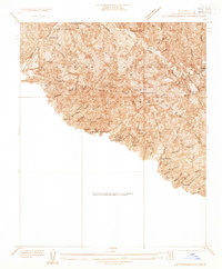
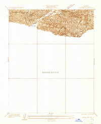
1930s Maps of Los Angeles, California
Explore 17 historic maps of Los Angeles from the 1930s. These maps offer a rare glimpse into what life looked like during the 1930s — showing old roads, neighborhoods, homes, and landmarks that have changed or disappeared over time.
Whether you're researching your family's past, planning a metal detecting trip, or studying how Los Angeles's landscape evolved across the 1930s, these high-resolution maps are a powerful tool for exploring the history of this region.
- Focus on a specific era: All maps on this page are from the 1930s, giving you a focused view of this time period.
- See what’s changed: Compare century-old streets, trails, and buildings to today's modern landscape using overlays and satellite layers.
- Research with precision: Use these maps for genealogy, historical research, land use analysis, or educational projects.
- View, download, or print: Maps are fully viewable online in high resolution, and can be downloaded or printed for your own records.
Start exploring Los Angeles's history through authentic maps from the 1930s. This is your window into the past.
Los Angeles, CA maps
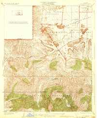
(17)- 1930 Map of Compton
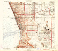
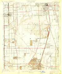 1930 Compton1930 Print · USGSThe South Bay and Gateway regions emerge as industrial powerhouses in this 1930s survey of the plains between Los Angeles and the coast. Trace the footprint of early oil operations at the Shell Oil Dominguez Refinery or locate community roots at the Gardena Japanese School and Woodlawn Cemetery.2 unique versions available
 - 1930 Map of Inglewood
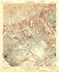
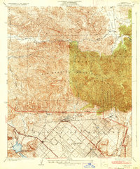
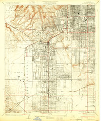 1930 Inglewood1930 Print · USGSThe South Bay and Inglewood areas are shown here during the early years of the aviation boom. You can trace the early airfields at Mines Aviation Field and Kelly's Airport or find local landmarks like the Wiseburn Sch.
 - 1932 Map of Zelzah
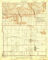 1932 Zelzah1932 Print · USGSThe San Fernando Valley is seen here during its agricultural peak in the early thirties, just as early poultry colonies were defining the local economy. Genealogists and historians can trace the foundations of Canoga Park and Reseda, alongside unique sites like the Runnymede Poultry Colony.
 - 1932 Map of Sunland
 1932 Sunland1932 Print · USGSThe San Fernando Valley and the Verdugo Mountains appear here during the early 1930s, showing a landscape of open washes and emerging street grids. Genealogists can trace early residences near Sunland or follow the rail stops at Roscoe and Hewitt.
 - 1932 Map of Dry Canyon
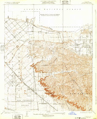
 1932 Dry Canyon1932 Print · USGSThe western San Fernando Valley appears in the early thirties as a landscape of large ranchos and nascent mountain communities. Genealogists and historians can trace the early footprints of Calabasas, the rural Calabasas School, and the winding Mulholland Highway.3 unique versions available
 - 1933 Map of Chatsworth
 1933 Chatsworth1933 Print · USGSThe Chatsworth area in the early thirties shows a unique blend of old ranching estates and new valley subdivisions. You can trace early property lines at Rancho Sombra del Roble or locate historic landmarks like the Garden of The Gods and Oakwood Cemetery.
 - 1933 Map of La Crescenta
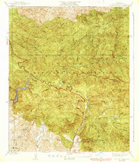
 1933 La Crescenta1933 Print · USGSThe Los Angeles mountains in the 1930s reveal a specialized landscape of canyon retreats and early forest management. Local historians can trace the foundations of Hill Crest Sanatorium, the spiritual retreat at Anandra Ashrama, and the remote Big Tujunga Ranger Station.
 - 1933 Map of Newhall
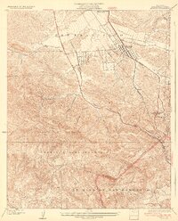 1933 Newhall1933 Print · USGSNewhall and the northern Santa Susana Mountains are shown in the early thirties as vital transit corridors for rail and road. Researchers can trace the path of the Southern Pacific through the Tunnel or locate the Dept of Commerce Landing Field.4 unique versions available
 - 1933 Map of Sunland
 1933 Sunland1933 Print · USGSThe San Gabriel Mountains and Angeles National Forest are captured in the early 1930s before the sprawl of Los Angeles reached these canyons. Genealogists and hikers can trace old property marks like Herreras Ranch and remote sites such as El Merrie Del or Selby Oaks.
 - 1934 Map of Torrance
 1934 Torrance1934 Print · USGSCoastal Los Angeles underwent a massive industrial and residential transformation during the interwar years. Researchers can trace early South Bay development through the sprawling Pacific Electric rail lines, the Union Oil Tank Farm, and neighborhood landmarks like Grant School.3 unique versions available
 - 1934 Map of Sawtelle
 1934 Sawtelle1934 Print · USGSWest Los Angeles and Santa Monica undergo a period of rapid suburban and institutional expansion during the early thirties. Local researchers can trace the development of UCLA, the expansive Soldiers Home, and the legendary Fox Studio grounds.3 unique versions available
 - 1934 Map of Little Tujunga
 1934 Little Tujunga1934 Print · USGSThe San Gabriel canyons come alive in the 1930s, showing a rugged landscape of high-altitude sanatoriums and family ranches. Trace the locations of De Mille Ranch, the Acme Mine, and the sprawling grounds of the Fairview Sanatorium.
 - 1934 Map of Venice
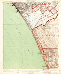 1934 Venice1934 Print · USGSThe Los Angeles coast in the mid-1930s reveals a landscape of tidal lagoons and burgeoning seaside industries. Researchers can trace the early rail network of the Pacific Electric, the footprint of Loyola University, and the massive Standard Oil Co Refinery.3 unique versions available
 - 1935 Map of Sylmar
 1935 Sylmar1935 Print · USGSThe San Fernando Valley meets the mountains in the 1930s as the suburbs began to climb into the foothills. Genealogists and historians can trace the early streets of Sylmar, the grounds of the El Retiro School for Girls, and the sprawling Ex Mission San Fernando lands.3 unique versions available
 - 1937 Map of Watts
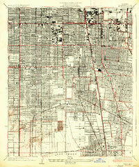 1937 Watts1937 Print · USGSLos Angeles and its southern neighbors show a landscape of rapid industrial and rail expansion in the mid-1930s. Researchers can trace the early residential street grids and commercial hubs surrounding the General Petroleum Tank Farm, Watts, and the Pacific Electric lines.2 unique versions available
 - 1939 Map of Little Tujunga
 1939 Little Tujunga1939 Print · USGSLos Angeles County's front range was a landscape of remote ranches and fire lookouts in the late 1930s. Researchers can locate canyon homesteads such as De Mille Ranch and Watts Ranch, or trace early health retreats like Fairview Sanatorium.3 unique versions available
 - 1939 Map of La Crescenta
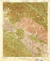 1939 La Crescenta1939 Print · USGSThe Crescenta Valley was rapidly developing into a series of foothill suburbs in the late thirties. Researchers can trace early street grids and landmarks like Hillcrest Sanitarium, the Burbank YMCA Camp, and the community of Verdugo City.4 unique versions available
End of results
Showing maps 1-17 of 17
Top cities near Los Angeles
- Long Beach historical maps
- Glendale historical maps
- Torrance historical maps
- Pasadena historical maps
- Simi Valley historical maps
- Inglewood historical maps
See more
Top neighborhoods of Los Angeles
- Pacific Palisades historical maps
- Harbor Pines historical maps
- Dana Strand Village historical maps
- Los Angeles Eco Village historical maps
- Thenard historical maps
- Studio City Neighborhood Council District historical maps
See more
Frequently asked questions
- What are the different types of historical maps available for Los Angeles?
- What is the oldest map of Los Angeles?
- Where can I purchase historical maps of Los Angeles for my home or office?
- Where can I download high-res historical maps of Los Angeles?
- Are there historical topographic maps available for Los Angeles?
- Is there historical aerial imagery available for Los Angeles?
- Where are historical maps of Los Angeles sourced from?