1940s Maps of Riverside County, California
Explore 85 historic maps of Riverside County from the 1940s. These maps offer a rare glimpse into what life looked like during the 1940s — showing old roads, neighborhoods, homes, and landmarks that have changed or disappeared over time.
Whether you're researching your family's past, planning a metal detecting trip, or studying how Riverside County's landscape evolved across the 1940s, these high-resolution maps are a powerful tool for exploring the history of this region.
- Focus on a specific era: All maps on this page are from the 1940s, giving you a focused view of this time period.
- See what’s changed: Compare century-old streets, trails, and buildings to today's modern landscape using overlays and satellite layers.
- Research with precision: Use these maps for genealogy, historical research, land use analysis, or educational projects.
- View, download, or print: Maps are fully viewable online in high resolution, and can be downloaded or printed for your own records.
Start exploring Riverside County's history through authentic maps from the 1940s. This is your window into the past.
Riverside County, CA maps
(85)- 1940 Map of Dome Rock Mts
 1940 Dome Rock Mts1940 Print · USGSThe Arizona and California borderlands along the Colorado River are captured here during the 1930s mining era. Researchers can trace historic prospecting sites like the Darling Mine and Goodman Mine or locate crossings at Diablo Pass.3 unique versions available
 - 1940 Map of Palm Springs, 1955 Print
 1940 Palm Springs1955 Print · USGSPalm Springs and the Coachella Valley are captured here as the mid-century resort era began. Trace the early street grids of Palm Springs, the rail operations at Palm Springs Station, and the boundaries of the Agua Caliente Indian Reservation.
 - 1940 Map of Frink, 1956 Print
 1940 Frink1956 Print · USGSThe Imperial County desert meets the shoreline of the Salton Sea in the early 1940s as infrastructure begins to reshape the basin. You can trace the Southern Pacific rail line through remote stops at Frink, Pope, and Wister, or locate the historic Frink Spring.
 - 1940 Map of Hemet Reservoir, 1956 Print
 1940 Hemet Reservoir1956 Print · USGSRiverside County's high-country terrain and tribal lands come into focus in this mid-century survey of the San Jacinto area. Genealogists and researchers can trace old ranch trails and remote sites like Anza, Keen Camp, and the Gold Shot Mine.
 - 1940 Map of Cottonwood Spring, 1956 Print
 1940 Cottonwood Spring1956 Print · USGSRiverside County in the early 1940s reveals a desert landscape in transition as massive water projects like the Colorado River Aqueduct and Coachella Canal take shape. Genealogists and historians can trace rail-side stops like Mortmar and Desert Camp near the Salton Sea shore.
 - 1940 Map of Iris Pass, 1956 Print
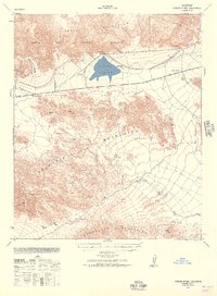
 1940 Iris Pass1956 Print · USGSThe Imperial County desert at the onset of World War II shows a landscape shifting from traditional trails to military use and large-scale irrigation. Trace historic desert travel via Ehrenberg Road, Salvation Spring, and the Coachella Canal.2 unique versions available
 - 1940 Map of Canyon Spring, 1957 Print
 1940 Canyon Spring1957 Print · USGSThe Colorado Desert of Riverside County is captured in this 1940s survey at a time of early infrastructure and ranching. Genealogists and researchers can trace remote water sources and landmarks like Hayfield Reservoir, Shaver Summit, and the Skylark Ranch.2 unique versions available
 - 1940 Map of Durmid, 1964 Print
 1940 Durmid1964 Print · USGSImperial County and the desert shoreline of the Salton Sea appear here in the early 1940s, just as new water infrastructure reached the area. Researchers can trace the Southern Pacific rail line through Durmid and Bertram or follow the early Anza Trail past Truckhaven.
 - 1941 Map of Prado
 1941 Prado1941 Print · USGSSouthern California's inland corridor is captured here in the 1930s, showing the river valley before the dam changed the landscape forever. Trace the old routes of the Union Pacific through Prado and locate local landmarks like the Pellissier Ranch.2 unique versions available
 - 1941 Map of Toro Peak, 1954 Print
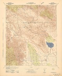
 1941 Toro Peak1954 Print · USGSThe Coachella Valley and Santa Rosa Mountains appear here in the early 1940s, just as modern desert communities were emerging. Trace the early development of Rancho Mirage and La Quinta or locate historical sites like the Garnet Queen Mine and Pinyon Flat.
 - 1941 Map of Clark Lake, 1956 Print
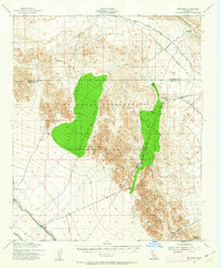
 1941 Clark Lake1956 Print · USGSBorrego Valley and the Santa Rosa Mountains are captured here in the early 1940s, showing a desert landscape before modern development. You can trace the early ranching history of the region through markers like Rancho De Anza, Brinniger Ranch, and the Anza Trail.
 - 1941 Map of Coachella, 1956 Print
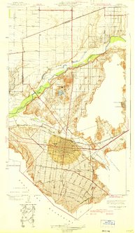
 1941 Coachella1956 Print · USGSRiverside County at the dawn of the 1940s reveals a desert landscape undergoing a profound transformation through irrigation and rail. Genealogists and historians can trace family-named landmarks and tribal boundaries near Indio, Mecca, and the Coachella Valley High Sch.2 unique versions available
 - 1941 Map of Edom, 1957 Print
 1941 Edom1957 Print · USGSThe Coachella Valley and Little San Bernardino Mountains appear here during the early 1940s as desert ranching and date cultivation expanded. Genealogists and historians can locate family-named landmarks like Two Bunch Palms Ranch, Snyder Date Gardens, and the original settlement at Edom.
 - 1941 Map of Margarita Peak, 1961 Print
 1941 Margarita Peak1961 Print · USGSSan Diego's coastal ranch lands and backcountry peaks are captured here in the early forties, just before the landscape shifted toward major military use. Researchers can trace historic family estates like Rancho Santa Margarita and old rail stops along the AT&SF RR near De Luz Station.
 - 1942 Map of Lake Elsinore
 1942 Lake Elsinore1942 Print · USGSIn the early war years, this area of Riverside County remained a mix of mining outposts, large ranchos, and lakefront towns. Genealogists and historians can trace family properties like Lyne Ranch and Baker Ranch or follow the old Santa Fe Railroad past Terra Cotta and Willard.
 - 1942 Map of Agua Dulce
 1942 Agua Dulce1942 Print · USGSThe Colorado Desert at the start of World War II reveals a landscape of high peaks and below-sea-level basins. Trace early desert life through the Oasis Sch, the remote Seventeen-Palms oasis, and the shoreline at Fish Springs.
 - 1942 Map of Clark Lake
 1942 Clark Lake1942 Print · USGSSan Diego and Riverside Counties were still largely defined by remote ranching and desert springs during the early 1940s. Genealogists and historians can trace the foundations of the valley at Brinniger Ranch, the Borrego Sch, and the Old Santa Rosa Indian Ruins.2 unique versions available
 - 1942 Map of Corona and Vicinity
 1942 Corona and Vicinity1942 Print · USGSThe Riverside County citrus belt thrives in the early 1940s, showing a landscape defined by orchards and early suburban expansion. Researchers can trace the development of Norco around the Norconian Club or locate regional landmarks like La Sierra College.
 - 1942 Map of San Bernardino
 1942 San Bernardino1942 Print · USGSThe San Bernardino Valley flourished as a railroad and citrus hub during the early years of the war. Researchers can trace the extensive tracks of the Atchison Topeka and Santa Fe, the National Orange Show grounds, and local landmarks like the Loma Linda Sanatorium.
 - 1942 Map of Margarita Peak
 1942 Margarita Peak1942 Print · USGSDuring the early years of World War II, this region of San Diego County remained a landscape of vast ranchos and scattered citrus groves. Genealogists can trace family holdings like Doville Ranch and community hubs including Deluz PO and the Horno Canyon CCC Camp.
 - 1942 Map of Riverside and Vicinity
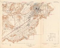 1942 Riverside and Vicinity1942 Print · USGSRiverside and its surrounding citrus lands are captured here during the early years of the war, showing a dense network of railroads and institutional grounds. Genealogists can trace family sites near the County Farm, Sherman Institute, or the Arlington Sta rail junction.2 unique versions available
 - 1942 Map of Temecula
 1942 Temecula1942 Print · USGSNorthern San Diego County and southern Riverside County are mapped here in the early 1940s, showing a rural landscape of canyons and ranch lands. Genealogists can trace family holdings at San Luis Rey Rancho or find early schools like Lilac Valley Sch.
 - 1942 Map of Blythe
 1942 Blythe1942 Print · USGSThe Lower Colorado River valley appears here in the early 1940s, showcasing the agricultural development of the Palo Verde Mesa alongside a booming mining industry. Researchers can locate remote desert outposts and extraction sites like Midland, the U S Gypsum Mine, and Nortons Landing.2 unique versions available
 - 1942 Map of Amboy
 1942 Amboy1942 Print · USGSSan Bernardino's high desert reveals its rail-and-road bones in the 1940s as transcontinental traffic pulses along the iconic route 66. Researchers can trace the water sources and small stations that made desert life possible, from Bonanza King Well and Wilhelm Camp to the rail stops at Amboy and Cadiz.
 - 1942 Map of MOON MTN, 1943 Print
 1942 MOON MTN1943 Print · USGSThe Colorado River valley and its surrounding desert ranges are shown here during the height of the Second World War. Historians can trace the locations of the Parker Alien Reception Center units and former workings at Valenzuella Mines.
Showing maps 1-25 of 85
Top cities of Riverside County
- Riverside historical maps
- Moreno Valley historical maps
- Corona historical maps
- Murrieta historical maps
- Temecula historical maps
- Jurupa Valley historical maps
See more
Frequently asked questions
- What are the different types of historical maps available for Riverside County?
- What is the oldest map of Riverside County?
- Where can I purchase historical maps of Riverside County for my home or office?
- Where can I download high-res historical maps of Riverside County?
- Are there historical topographic maps available for Riverside County?
- Is there historical aerial imagery available for Riverside County?
- Where are historical maps of Riverside County sourced from?