1930s Maps of Riverside County, California
Explore 8 historic maps of Riverside County from the 1930s. These maps offer a rare glimpse into what life looked like during the 1930s — showing old roads, neighborhoods, homes, and landmarks that have changed or disappeared over time.
Whether you're researching your family's past, planning a metal detecting trip, or studying how Riverside County's landscape evolved across the 1930s, these high-resolution maps are a powerful tool for exploring the history of this region.
- Focus on a specific era: All maps on this page are from the 1930s, giving you a focused view of this time period.
- See what’s changed: Compare century-old streets, trails, and buildings to today's modern landscape using overlays and satellite layers.
- Research with precision: Use these maps for genealogy, historical research, land use analysis, or educational projects.
- View, download, or print: Maps are fully viewable online in high resolution, and can be downloaded or printed for your own records.
Start exploring Riverside County's history through authentic maps from the 1930s. This is your window into the past.
Riverside County, CA maps
(8)- 1931 Map of Vallecito
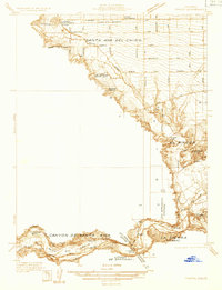
 1931 Vallecito1931 Print · USGSThe Colorado Desert and its surrounding ranges are mapped here in the early thirties, showcasing a landscape defined by scarce water and massive terrain. Genealogists can trace isolated desert outposts like Fig Tree John and Agua Dulce or the original footprint of Borego Springs.
 - 1931 Map of Moon Mtn, 1955 Print
 1931 Moon Mtn1955 Print · USGSThe Arizona-California borderlands are captured here in the early thirties, defined by the winding Colorado River and the stark Dome Rock Mountains. Historians and prospectors can trace mineral workings at the Valenzuella Mine and Mammoth Mine.2 unique versions available
 - 1932 Map of Moon Mtn
 1932 Moon Mtn1932 Print · USGSThe Arizona-California borderlands are captured here in the early 1930s, showing the intersection of tribal lands and desert mining. Genealogists and historians can trace the early boundaries of the Colorado River Indian Reservation and locate industrial sites like the Valenzuela Mine.2 unique versions available
 - 1933 Map of Cunningham Mtn
 1933 Cunningham Mtn1933 Print · USGSThe Arizona-California borderlands were a hub of mining and early desert transit during the early 1930s. Researchers can trace the path of the Route No. 60 Sunkist Trail and locate remote operations like the Cinnabar Mine and Beamer Well.4 unique versions available
 - 1933 Map of Prado
 1933 Prado1933 Print · USGSIn the early 1930s, the Chino Valley was a hub of irrigation canals and rail-side settlements before later development changed the landscape. Genealogists and historians can trace old homesteads like Pellissier Ranch and schools like the California Junior Republic School.
 - 1938 Map of Colton
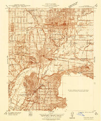 1938 Colton1938 Print · USGSThe rail and citrus hubs of San Bernardino County are in full bloom during the late 1930s. Researchers can trace the industrial infrastructure of Colton and Rialto, including the Cement Plant and the grounds of the National Orange Show.
 - 1939 Map of Warner Springs, 1956 Print
 1939 Warner Springs1956 Print · USGSIn the high backcountry of San Diego and Riverside counties just before the 1940s, this area shows a landscape of cattle ranges and mountain outposts. Genealogists and researchers can trace early settlements and trails including Holcomb Village, Warner Springs, and the historic Deadman Hole spring.
 - 1939 Map of Palomar Mountain, 1957 Print
 1939 Palomar Mountain1957 Print · USGSNorthern San Diego County is shown in the late 1930s as a landscape of high valleys and remote mountain outposts. Researchers can find the iconic Observatory, the historic Stage Sta, and the borders of the La Jolla Indian Reservation.3 unique versions available
End of results
Showing maps 1-8 of 8
Top cities of Riverside County
- Riverside historical maps
- Moreno Valley historical maps
- Corona historical maps
- Murrieta historical maps
- Temecula historical maps
- Jurupa Valley historical maps
See more
Frequently asked questions
- What are the different types of historical maps available for Riverside County?
- What is the oldest map of Riverside County?
- Where can I purchase historical maps of Riverside County for my home or office?
- Where can I download high-res historical maps of Riverside County?
- Are there historical topographic maps available for Riverside County?
- Is there historical aerial imagery available for Riverside County?
- Where are historical maps of Riverside County sourced from?