1960s Maps of Riverside County, California
Explore 39 historic maps of Riverside County from the 1960s. These maps offer a rare glimpse into what life looked like during the 1960s — showing old roads, neighborhoods, homes, and landmarks that have changed or disappeared over time.
Whether you're researching your family's past, planning a metal detecting trip, or studying how Riverside County's landscape evolved across the 1960s, these high-resolution maps are a powerful tool for exploring the history of this region.
- Focus on a specific era: All maps on this page are from the 1960s, giving you a focused view of this time period.
- See what’s changed: Compare century-old streets, trails, and buildings to today's modern landscape using overlays and satellite layers.
- Research with precision: Use these maps for genealogy, historical research, land use analysis, or educational projects.
- View, download, or print: Maps are fully viewable online in high resolution, and can be downloaded or printed for your own records.
Start exploring Riverside County's history through authentic maps from the 1960s. This is your window into the past.
Riverside County, CA maps
(39)- 1960 Map of Santa Ana
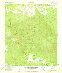
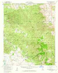
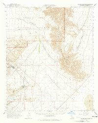
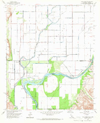
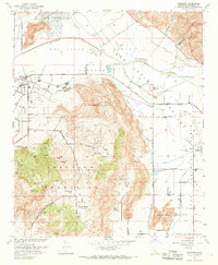
 1960 Santa Ana1960 Print · USGSSouthern California's coastal plains and inland deserts meet in this mid-century survey of the burgeoning Orange and Riverside county corridors. Researchers can trace the layout of early freeway systems, find tribal lands like the Soboba Indian Reservation, and locate military landmarks such as March Field.2 unique versions available
 - 1960 Map of Beauty Mountain, 1961 Print
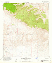
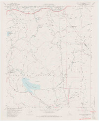
 1960 Beauty Mountain1961 Print · USGSThe high desert border between Riverside and San Diego Counties is captured here in the early sixties, showing a landscape of remote valleys and high peaks. Genealogists and historians can locate legacy outposts like Mitchell Camp, the Pawnee Mine, and trails through Chihuahua Valley.4 unique versions available
 - 1960 Map of Clark Lake NE, 1961 Print
 1960 Clark Lake NE1961 Print · USGSThe high desert borderlands of Riverside and San Diego counties are captured here in the early 1960s. Genealogists and desert researchers can trace the primitive Rockhouse Trail, locate isolated Ruins, and follow the deep cuts of Martinez Canyon.4 unique versions available
 - 1960 Map of Bucksnort Mtn, 1961 Print
 1960 Bucksnort Mtn1961 Print · USGSThe high desert borderlands of Riverside and San Diego counties are captured here in the early sixties, showing a landscape defined by seasonal water and high peaks. Tracing the primitive roads through Terwilliger Valley, you can find remote landmarks like Tule Spring, Combs Peak, and Turkey Track.4 unique versions available
 - 1960 Map of Clark Lake, 1962 Print
 1960 Clark Lake1962 Print · USGSBorrego Springs and the surrounding desert floor are shown in detail during the early sixties as the community took its modern shape. Researchers can trace the development of Christmas Circle and locate historic outposts like Middle Willows or the El Vado Historical Marker.3 unique versions available
 - 1960 Map of Warner Springs, 1962 Print
 1960 Warner Springs1962 Print · USGSWarner Springs and the San Diego back country appear here in the early sixties, a landscape of cattle ranges and mountain outposts. Researchers can trace the Survival Training School (US Navy), the remote village of San Ignacio, and the historic Warner Hot Spring.2 unique versions available
 - 1963 Map of Salton Sea
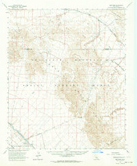
 1963 Salton Sea1963 Print · USGSThe Colorado Desert during the early sixties shows a landscape defined by massive water projects and Cold War military ranges. Trace the growth of Salton City and Brawley, or locate remote desert outposts like the Paymaster Mine and Desert Center.
 - 1963 Map of Iris Pass, 1964 Print
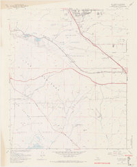
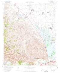
 1963 Iris Pass1964 Print · USGSThe Colorado Desert at the Imperial and Riverside county line reveals a landscape of mid-century infrastructure and mining. Trace the historic Bradshaw Road past Imperial Buttes Mine and follow the Coachella Canal through the East Mesa.2 unique versions available
 - 1963 Map of Chuckwalla Mountains, 1965 Print
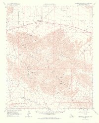 1963 Chuckwalla Mountains1965 Print · USGSThe Riverside County desert comes into focus in the 1960s, showing a landscape defined by mining operations and increasing military presence. Researchers can trace the legacy of remote outposts like Desert Center or locate historic extraction sites such as the Red Cloud Mine and Lost Pony Mine.3 unique versions available
 - 1963 Map of Hayfield, 1965 Print
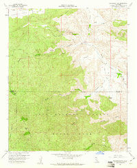
 1963 Hayfield1965 Print · USGSRiverside County’s desert interior is seen here in the early sixties, highlighting the massive water infrastructure of the Colorado River Aqueduct. Researchers can trace the path of Bradshaw Road and locate remote outposts like Hayfield Station and Clemens Well (Dry).3 unique versions available
 - 1963 Map of Coxcomb Mountains, 1965 Print
 1963 Coxcomb Mountains1965 Print · USGSThe Colorado desert comes into sharp focus during the early sixties, showing the intersection of heavy industry and protected wilderness. Researchers can trace the path of the Colorado River Aqueduct and locate facilities at Eagle Mountain and Pinto Wells.2 unique versions available
 - 1963 Map of Hexie Mountains, 1965 Print
 1963 Hexie Mountains1965 Print · USGSRiverside County’s desert interior was a site of intense mineral exploration and early conservation efforts in the 1960s. Mineral hunters and historians can trace old claims like the Pinto Mine and Snow Cloud Mine or locate historic water points like the Pinkham Well (Site).3 unique versions available
 - 1963 Map of Pinto Basin, 1965 Print
 1963 Pinto Basin1965 Print · USGSThe high desert of the Pinto Basin and Eagle Mountains is documented here during a period of active mineral prospecting. Researchers can trace the locations of numerous desert claims and water sources, including the Black Eagle Mine, Storm Jade Mine, and Mission Wells.2 unique versions available
 - 1964 Map of Mule Wash, 1966 Print
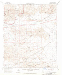
 1964 Mule Wash1966 Print · USGSThis borderland survey from the mid-sixties tracks the Colorado River as it winds between Riverside and Yuma counties. Map collectors and historians can trace the early irrigation canals of the Palo Verde Valley and the vast, unpaved expanses of the Yuma Proving Ground via the Cibola Road.2 unique versions available
 - 1965 Map of Santa Ana
 1965 Santa Ana1965 Print · USGSSouthern California is captured in a decade of rapid growth, showing the coastal expansion from Santa Ana down to Oceanside. Genealogists and historians can trace the mid-century development of places like Garden Grove or the rural reaches of Escondido and the Palomar Observatory.
 - 1965 Map of Salton Sea
 1965 Salton Sea1965 Print · USGSThe Colorado Desert and Imperial Valley are caught in a period of intense irrigation and military expansion during the mid-sixties. Researchers can trace the desert's industrial footprint through the Eagle Mountain Mine, the remote Desert Center, and the Salton Sea Test Base.
 - 1965 Map of Palo Verde, 1966 Print
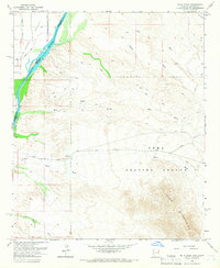
 1965 Palo Verde1966 Print · USGSThe Colorado River borderlands in the mid-sixties reveal a landscape defined by industrial irrigation and desert crossings. You can trace the historic Bradshaw Trail, locate the Cibola Bridge, and explore the waterways of the Cibola National Wildlife Refuge.4 unique versions available
 - 1966 Map of San Bernardino
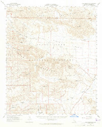
 1966 San Bernardino1966 Print · USGSThe San Bernardino Valley and Mojave Desert met during a period of massive military and suburban growth in the mid-sixties. Genealogists and historians can trace the development of Edwards Air Force Base, old desert mines like the Bagdad Chase Mine, and mountain communities near Big Bear Lake.
 - 1966 Map of Guasti, 1969 Print
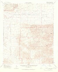
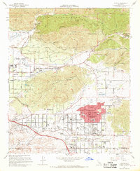
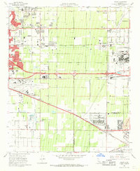 1966 Guasti1969 Print · USGSThe Inland Empire is shown at a pivotal moment of industrial and suburban growth in the mid-1960s. Genealogists and researchers can locate family-named landmarks like the John Rains House, the historic Guasti settlement, and local centers like Mission Bell Ch.4 unique versions available
 - 1967 Map of Black Star Canyon, 1968 Print
 1967 Black Star Canyon1968 Print · USGSThe Santa Ana Mountains in the late sixties reveal a landscape defined by mining operations and new infrastructure. Researchers can trace resource extraction at the Black Star Coal Mine and locate landmarks like Beeks Place or the Rocket Fuel Test Site.7 unique versions available
 - 1967 Map of El Casco, 1968 Print
 1967 El Casco1968 Print · USGSRiverside County at the peak of the sixties shows a landscape of developing towns and steep canyon passes. Genealogists and historians can trace Eden Hot Springs, the Southern Pacific rail route, and local landmarks like El Casco Lake or the Forest Lawn Memorial Gardens.6 unique versions available
 - 1967 Map of Lakeview, 1968 Print
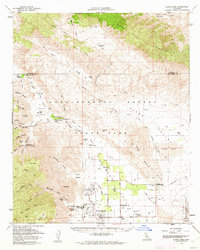
 1967 Lakeview1968 Print · USGSLakeview and the surrounding Riverside County foothills are captured here during a period of expanding water infrastructure in the late sixties. Researchers can trace the Colorado River Aqueduct, find the Maze Stone Historical Marker, and locate the Bar V Ranch.4 unique versions available
 - 1967 Map of Yucaipa, 1968 Print
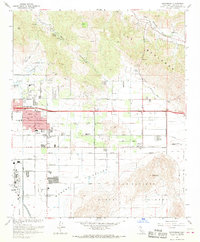
 1967 Yucaipa1968 Print · USGSThe Yucaipa Valley is captured in the late 1960s during a period of rapid suburban expansion near the foothills of the San Bernardino Mountains. Researchers can trace development through old schools like Yucaipa High Sch and landmarks such as the Crafton Hills Airport.4 unique versions available
 - 1967 Map of Prado Dam, 1968 Print
 1967 Prado Dam1968 Print · USGSSan Bernardino County at the height of the 1960s reveals a landscape balancing massive flood control projects with institutional expansion. Trace the historic Yorba Slaughter Adobe and the grounds of Boys Republic near the rising Prado Dam.5 unique versions available
 - 1967 Map of Sunnymead, 1968 Print
 1967 Sunnymead1968 Print · USGSRiverside County enters a period of suburban expansion and military readiness in the late sixties as the Inland Empire begins to transform. Researchers can trace local development through Sunnymead Sch, the industrial presence of March Air Force Base, and the winding paths of Reche Canyon.5 unique versions available
Showing maps 1-25 of 39
Top cities of Riverside County
- Riverside historical maps
- Moreno Valley historical maps
- Corona historical maps
- Murrieta historical maps
- Temecula historical maps
- Jurupa Valley historical maps
See more
Frequently asked questions
- What are the different types of historical maps available for Riverside County?
- What is the oldest map of Riverside County?
- Where can I purchase historical maps of Riverside County for my home or office?
- Where can I download high-res historical maps of Riverside County?
- Are there historical topographic maps available for Riverside County?
- Is there historical aerial imagery available for Riverside County?
- Where are historical maps of Riverside County sourced from?