1920s Maps of San Luis Obispo County, California
Explore 4 historic maps of San Luis Obispo County from the 1920s. These maps offer a rare glimpse into what life looked like during the 1920s — showing old roads, neighborhoods, homes, and landmarks that have changed or disappeared over time.
Whether you're researching your family's past, planning a metal detecting trip, or studying how San Luis Obispo County's landscape evolved across the 1920s, these high-resolution maps are a powerful tool for exploring the history of this region.
- Focus on a specific era: All maps on this page are from the 1920s, giving you a focused view of this time period.
- See what’s changed: Compare century-old streets, trails, and buildings to today's modern landscape using overlays and satellite layers.
- Research with precision: Use these maps for genealogy, historical research, land use analysis, or educational projects.
- View, download, or print: Maps are fully viewable online in high resolution, and can be downloaded or printed for your own records.
Start exploring San Luis Obispo County's history through authentic maps from the 1920s. This is your window into the past.
San Luis Obispo County, CA maps
(4)- 1921 Map of Cape San Martin
 1921 Cape San Martin1921 Print · USGSThe Big Sur coast and its remote mining interior are documented here during the early twenties, prior to the construction of the modern highway. Local historians can trace family operations like the Krenkels Ranch or investigate the gold-mining era at the Los Burros Mine and the Calizona Mines.6 unique versions available
 - 1922 Map of Pozo
 1922 Pozo1922 Print · USGSSan Luis Obispo County backcountry reveals its rural school network and forest boundaries in the years following the Great War. Genealogists and local historians can trace the locations of the El Dorado School and Highland School near the settlement of Pozo.3 unique versions available
 - 1922 Map of Nipomo
 1922 Nipomo1922 Print · USGSThe ranching and rail landscape of coastal California is documented here shortly after the Great War. Genealogists can trace family holdings and local landmarks including the Pacific Coast Ry, the Colwell Ranch, and rural sites like the Santa Manuela School.4 unique versions available
 - 1927 Map of Piedras Blancas
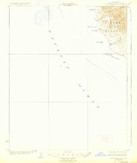 1927 Piedras Blancas1927 Print · USGSThe San Luis Obispo coastline appears here in the years following the Great War, showing a sparsely populated landscape of ranching and maritime navigation. Genealogists can locate the Washington School and trace landmarks like Piedras Blancas Point and Arroyo de la Cruz.2 unique versions available
End of results
Showing maps 1-4 of 4
Top cities of San Luis Obispo County
- San Luis Obispo historical maps
- Atascadero historical maps
- Paso Robles historical maps
- Arroyo Grande historical maps
- Grover Beach historical maps
- Morro Bay historical maps
See more
Frequently asked questions
- What are the different types of historical maps available for San Luis Obispo County?
- What is the oldest map of San Luis Obispo County?
- Where can I purchase historical maps of San Luis Obispo County for my home or office?
- Where can I download high-res historical maps of San Luis Obispo County?
- Are there historical topographic maps available for San Luis Obispo County?
- Is there historical aerial imagery available for San Luis Obispo County?
- Where are historical maps of San Luis Obispo County sourced from?