1920s Maps of Connecticut
Explore 20 historic maps of Connecticut from the 1920s. These maps offer a rare glimpse into what life looked like during the 1920s — showing old roads, neighborhoods, homes, and landmarks that have changed or disappeared over time.
Whether you're researching your family's past, planning a metal detecting trip, or studying how Connecticut's landscape evolved across the 1920s, these high-resolution maps are a powerful tool for exploring the history of this region.
- Focus on a specific era: All maps on this page are from the 1920s, giving you a focused view of this time period.
- See what’s changed: Compare century-old streets, trails, and buildings to today's modern landscape using overlays and satellite layers.
- Research with precision: Use these maps for genealogy, historical research, land use analysis, or educational projects.
- View, download, or print: Maps are fully viewable online in high resolution, and can be downloaded or printed for your own records.
Start exploring Connecticut's history through authentic maps from the 1920s. This is your window into the past.
Connecticut maps
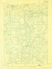
(20)- 1920 Map of Moosup
 1920 Moosup1920 Print · USGSEastern Connecticut and the Rhode Island border were thriving hubs of textile milling and rail transit just after the Great War. Genealogists and local historians can trace family-named locations such as Hopkins Hollow, industrial sites like Sterling Station, and the intricate rail network at Plainfield Junction.
 - 1920 Map of Bridgeport
 1920 Bridgeport1920 Print · USGSCoastal Connecticut comes alive in the early twentieth century as a hub of maritime commerce and industrial growth. Researchers can trace the development of Bridgeport and Milford, or locate specific landmarks like Charles Island and Beardsley Park.
 - 1920 Map of Springfield
 1920 Springfield1920 Print · USGSGreater Springfield and the Pioneer Valley are captured here during a period of intense industrial and rail expansion. Genealogists and local historians can trace the foundations of neighborhoods like Indian Orchard, locate the Shaker Sta, or study the early rail alignments of the Boston and Albany RR.
 - 1921 Map of Tolland
 1921 Tolland1921 Print · USGSTolland County at the start of the twenties reveals a complex network of electric rail lines and industrial waterpower. Genealogists can locate family homes and centers of trade like Stafford Springs, Talcottville, and the Conn. Epileptic Colony.
 - 1921 Map of Gardiners Island
 1921 Gardiners Island1921 Print · USGSThe maritime landscape of eastern Long Island is detailed here in the years following the Great War. Researchers can trace historic shorelines and landings like Quincetree Landing, locate the military grounds of Fort Terry, or find family-named sites such as Barnes Landing and Hicks.
 - 1921 Map of New London
 1921 New London1921 Print · USGSCoastal Connecticut thrived between the world wars as a strategic naval and rail hub. Genealogists and historians can trace the foundations of local life through the Norwich State Hospital, the sprawling US Naval Station, and small hamlets like Gales Ferry or Flanders Village.
 - 1921 Map of Woodstock
 1921 Woodstock1921 Print · USGSWindham County villages and highland ridges are captured here during the early twentieth century, showing a landscape of small mill towns and glacial ponds. Researchers can trace the path of the New York New Haven and Hartford Railroad or locate family roots in Atwoodville, Phoenixville, or Mansfield Hollow.
 - 1921 Map of New Haven
 1921 New Haven1921 Print · USGSNew Haven and its harbor appear in the early twenties as a thriving industrial and maritime hub. Genealogists and historians can trace rail-era neighborhoods and shoreline landmarks like Savin Rock, Fair Haven, and the Mt. Carmel Sta. depot.
 - 1921 Map of Brookfield
 1921 Brookfield1921 Print · USGSMassachusetts and Connecticut borderlands appear here in the early twentieth century as a complex landscape of hill farms, industrial villages, and rail corridors. Genealogists can locate family landmarks like Foster Hill or trace the early industrial footprint of Leadmine and the Boston and Albany Railroad.
 - 1921 Map of Webster
 1921 Webster1921 Print · USGSThe industrial valleys and hill towns of southern Worcester County are seen here just after the Great War. Genealogists can trace the rail-centered growth of Webster and Auburn Sta. or locate old village centers like Cherry Valley and Rochdale.
 - 1921 Map of Stonington
 1921 Stonington1921 Print · USGSCoastal Connecticut and Rhode Island meet here between the wars, where river and rail drive the regional economy. Genealogists can trace family footprints in North Stonington and Westerly, or locate the Silex Mine and the Light House at Stonington.
 - 1928 Map of Windsor Locks
 1928 Windsor Locks1928 Print · USGSThe northern Connecticut River Valley is captured here in the late 1920s during a period of industrial and agricultural prosperity. Researchers can trace the path of the New York New Haven and Hartford railroad through Windsor Locks and Poquonock.
 - 1928 Map of Cromwell
 1928 Cromwell1928 Print · USGSMiddlesex County emerges in high detail during the late Prohibition era as aerial photography began to modernize American cartography. Researchers can trace the rail lines of the New York New Haven and Hartford through Rockfall, Westfield, and the waterfront at Willow Island.
 - 1928 Map of Windsor
 1928 Windsor1928 Print · USGSGreater Hartford was entering a period of suburban growth in the late 1920s, bridging the gap between the city and the riverside towns of the Connecticut Valley. You can trace early street grids and rail lines serving Windsor, Cottage Grove, and East Hartford.
 - 1928 Map of Glastonbury
 1928 Glastonbury1928 Print · USGSHartford County's riverfront and upland villages are captured here in the late 1920s through early aerial surveying. Genealogists and local historians can trace the early footprints of Naubuc, South Glastonbury, and Hopewell along the Connecticut River.
 - 1928 Map of Long Meadow
 1928 Long Meadow1928 Print · USGSNorth-central Connecticut and the Massachusetts border are captured here in the late twenties, showing the region's transition into the modern era. Genealogists can trace the rail-and-river network through Thompsonville and find the site of Shaker Sta.
 - 1928 Map of Broad Brook
 1928 Broad Brook1928 Print · USGSNorthern Connecticut’s river valley and fertile uplands are preserved here as they appeared in the late twenties. Genealogists and local historians can trace family-named hubs like Sadd's Mills and Osborne or locate old crossings at Warehouse Point.
 - 1928 Map of Carmel
 1928 Carmel1928 Print · USGSNear the New York and Connecticut border during the late 1920s, this landscape shows a network of massive reservoirs built to serve the city. Genealogists and historians can trace rail-era developments like the New York and Harlem RR and locate sites such as the Tilly Foster Mine and Farmers Mills.5 unique versions available
 - 1928 Map of Manchester
 1928 Manchester1928 Print · USGSHartford County's industrial and rural landscape is captured here in the late twenties, during a period of significant regional growth. Researchers can trace the path of the New York New Haven and Hartford railroad through local hubs like Buckland and Manchester Green.
 - 1928 Map of Mittineague
 1928 Mittineague1928 Print · USGSThe Connecticut and Massachusetts borderlands appear here in the late twenties during an early aerial survey of the region. Researchers can trace the path of the N Y N H & H railroad through Suffield and locate rural landmarks like Buck Hill and Still Brook.
End of results
Showing maps 1-20 of 20
Top cities of Connecticut
- Bridgeport historical maps
- Stamford historical maps
- Hartford historical maps
- New Haven historical maps
- Waterbury historical maps
- Norwalk historical maps
See more
Frequently asked questions
- What are the different types of historical maps available for Connecticut?
- What is the oldest map of Connecticut?
- Where can I purchase historical maps of Connecticut for my home or office?
- Where can I download high-res historical maps of Connecticut?
- Are there historical topographic maps available for Connecticut?
- Is there historical aerial imagery available for Connecticut?
- Where are historical maps of Connecticut sourced from?