1930s Maps of Connecticut
Explore 12 historic maps of Connecticut from the 1930s. These maps offer a rare glimpse into what life looked like during the 1930s — showing old roads, neighborhoods, homes, and landmarks that have changed or disappeared over time.
Whether you're researching your family's past, planning a metal detecting trip, or studying how Connecticut's landscape evolved across the 1930s, these high-resolution maps are a powerful tool for exploring the history of this region.
- Focus on a specific era: All maps on this page are from the 1930s, giving you a focused view of this time period.
- See what’s changed: Compare century-old streets, trails, and buildings to today's modern landscape using overlays and satellite layers.
- Research with precision: Use these maps for genealogy, historical research, land use analysis, or educational projects.
- View, download, or print: Maps are fully viewable online in high resolution, and can be downloaded or printed for your own records.
Start exploring Connecticut's history through authentic maps from the 1930s. This is your window into the past.
Connecticut maps
(12)- 1933 Map of Feeding Hills
 1933 Feeding Hills1933 Print · USGSThe Lower Pioneer Valley in the early thirties reveals a landscape shaped by the ridge of Proven Mountain and the winding Westfield River. Genealogists and historians can locate legacy institutions like the Westfield State Sanatorium and trace local neighborhoods from Frog Bottom to Feeding Hills.
 - 1933 Map of Longmeadow
 1933 Longmeadow1933 Print · USGSThe Connecticut River valley thrives in the early 1930s as a hub of industry, education, and transport. Researchers can trace historic family plots at Springfield Cemetery or locate old rail hubs like Union Station and the Longmeadow Sta.
 - 1934 Map of Niantic
 1934 Niantic1934 Print · USGSCoastal Connecticut in the 1930s reveals a landscape of growing beach colonies and significant state institutions. Genealogists and historians can trace family roots through Flanders Cem, or locate landmarks like the Seaside Connecticut State Sanatorium and the New York New Haven and Hartford Railroad.
 - 1935 Map of Montville
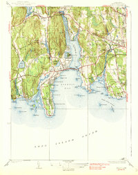
 1935 Montville1935 Print · USGSNew London County in the mid-thirties remains a landscape of tightly clustered villages, family-named hills, and critical water reserves. Local historians can trace early community life through sites like Chesterfield Cem, the Yale Engineering Camp, and schools such as Chapell Hill Sch and West Side Sch.
 - 1937 Map of Southwick
 1937 Southwick1937 Print · USGSHampden County's borderlands are captured in the late 1930s, showing the early infrastructure and rural character of this Massachusetts-Connecticut corridor. Local historians can trace old transit lines like the New York and New Haven Road and identify ancestral sites at Granville Cem or the Northeast Cem.
 - 1938 Map of New London
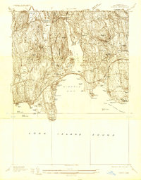
 1938 New London1938 Print · USGSThe Thames River waterfront and Fishers Island are shown in detail during the late 1930s. Researchers can trace military and maritime history at Fort Trumbull and Fort H G Wright, or locate family sites like Bethel Cem and Fishtown Chapel.3 unique versions available
 - 1938 Map of West Springfield
 1938 West Springfield1938 Print · USGSHampden County's river valleys and ridgelines are captured here in the 1930s during a period of steady institutional and residential growth. Genealogists and local historians can trace the foundations of WESTFIELD and AGAWAM, locating family landmarks like Shea Corner, St James Ch, and the Suffield Street Sch.3 unique versions available
 - 1938 Map of Niantic
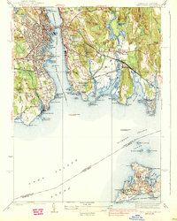
 1938 Niantic1938 Print · USGSNiantic and East Lyme are captured here in the mid-1930s as the Connecticut shoreline evolved into a premier summer destination. Genealogists can locate family sites at Jordan Cem or St Marys Cem, while tracing the old Boston Post Road.3 unique versions available
 - 1938 Map of Springfield South
 1938 Springfield South1938 Print · USGSSpringfield and its southern neighbors appear here in the late 1930s, showing a bustling industrial city and its growing suburbs before postwar change. Researchers can trace historic rail lines through Union Sta or locate family plots in Oak Grove Cemetery and St Michaels Cemetery.3 unique versions available
 - 1939 Map of Hampden
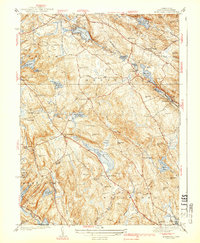
 1939 Hampden1939 Print · USGSHampden and Wilbraham are captured here just before the mid-century expansion of the Springfield suburbs. Researchers can trace historic local sites like Wilbraham Academy, find family names at Prospect Hill Cem, and locate the small settlement of Baptist Village.
 - 1939 Map of Montville
 1939 Montville1939 Print · USGSNew London County hills and valleys were a network of small mill ponds and upland farmsteads in the mid-1930s. Genealogists can trace family names at Raymond Hill Cem or locate rural landmarks like Chapel Hill Sch and the Central Vermont RR.3 unique versions available
 - 1939 Map of Springfield South
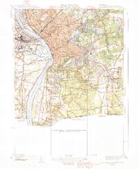 1939 Springfield South1939 Print · USGSThe Pioneer Valley hums with industrial and civic energy in the late thirties as rail hubs and river crossings define the landscape. Trace the urban layout of Springfield through landmarks like the U S Armory, Union Sta, and Oak Grove Cemetery.2 unique versions available
End of results
Showing maps 1-12 of 12
Top cities of Connecticut
- Bridgeport historical maps
- Stamford historical maps
- Hartford historical maps
- New Haven historical maps
- Waterbury historical maps
- Norwalk historical maps
See more
Frequently asked questions
- What are the different types of historical maps available for Connecticut?
- What is the oldest map of Connecticut?
- Where can I purchase historical maps of Connecticut for my home or office?
- Where can I download high-res historical maps of Connecticut?
- Are there historical topographic maps available for Connecticut?
- Is there historical aerial imagery available for Connecticut?
- Where are historical maps of Connecticut sourced from?