1990s Maps of Connecticut
Explore 9 historic maps of Connecticut from the 1990s. These maps offer a rare glimpse into what life looked like during the 1990s — showing old roads, neighborhoods, homes, and landmarks that have changed or disappeared over time.
Whether you're researching your family's past, planning a metal detecting trip, or studying how Connecticut's landscape evolved across the 1990s, these high-resolution maps are a powerful tool for exploring the history of this region.
- Focus on a specific era: All maps on this page are from the 1990s, giving you a focused view of this time period.
- See what’s changed: Compare century-old streets, trails, and buildings to today's modern landscape using overlays and satellite layers.
- Research with precision: Use these maps for genealogy, historical research, land use analysis, or educational projects.
- View, download, or print: Maps are fully viewable online in high resolution, and can be downloaded or printed for your own records.
Start exploring Connecticut's history through authentic maps from the 1990s. This is your window into the past.
Connecticut maps
(9)- 1993 Map of Waterbury
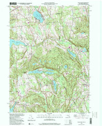
 1993 Waterbury1993 Print · USGSWestern Connecticut and the Hudson Valley appear in the early nineties as a landscape of established industrial cities and deep forest preserves. Researchers can trace the rail corridors of the Metro-North Railroad or locate family sites near the Taft School and Riverside Cemetery.
 - 1994 Map of Hartford, 1995 Print
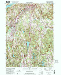
 1994 Hartford1995 Print · USGSGreater Hartford and the Connecticut River Valley are captured here in the mid-nineties, showing the dense intersection of industry and academia. Trace the urban footprint of the State Capitol and Trinity College or locate the sprawling grounds of the University of Connecticut.2 unique versions available
 - 1997 Map of Tolland Center, 1999 Print
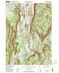
 1997 Tolland Center1999 Print · USGSThe Berkshires and Litchfield Hills meet here in the late nineties, where massive state forests border the Farmington River valley. Genealogists and hikers can locate the Sandisfield Cem, Rollhouse School, and several camps along the shores of Colebrook River Lake.
 - 1997 Map of Ashley Falls, 1999 Print
 1997 Ashley Falls1999 Print · USGSThe Housatonic Valley at the tri-state border shows a landscape of deep forests and river towns in the late 1990s. Genealogists and hikers can locate the Appalachian Trail, family Cem sites, and early institutions like the Berkshire Sch.
 - 1997 Map of Southwick, 2000 Print
 1997 Southwick2000 Print · USGSThe Massachusetts-Connecticut border at the close of the twentieth century reveals a landscape of massive reservoirs and wooded state forests. Researchers can trace ancestral sites at the Southwick Ancient Burial Grounds or explore the terrain around Sweetman Mountain and Cobble Mountain Reservoir.
 - 1998 Map of Pawling, 2000 Print
 1998 Pawling2000 Print · USGSThe Harlem Valley and Quaker Hill highlands come into focus at the end of the century, showing the borderlands between New York and Connecticut. Researchers can trace the path of the Appalachian National Scenic Trail or locate family roots near Hurd Corners and Akins Corners.
 - 1998 Map of Peach Lake, 2001 Print
 1998 Peach Lake2001 Print · USGSThe New York and Connecticut borderlands appear here in the late 1990s as a landscape of ridges and reservoir-fed valleys. Genealogists can locate family sites near St Johns Ch, North Salem, and the Peach Lake Meetinghouse.
 - 1998 Map of Dover Plains, 2001 Print
 1998 Dover Plains2001 Print · USGSThe Harlem Valley and the Connecticut borderlands are captured here in the late twentieth century, showing a landscape of steep ridges and riverside villages. Researchers can trace the path of the Metro North rail line through Dover Plains, find the historic The Stone Church, and locate the Schaghticoke Indian Reservation.
 - 1998 Map of Mount Kisco, 2001 Print
 1998 Mount Kisco2001 Print · USGSWestchester County at the close of the twentieth century shows a landscape of established villages and vital reservoirs. Genealogists and local historians can trace residential growth around Mount Kisco or locate family sites near St Matthews Ch and Oakwood Cem.
End of results
Showing maps 1-9 of 9
Top cities of Connecticut
- Bridgeport historical maps
- Stamford historical maps
- Hartford historical maps
- New Haven historical maps
- Waterbury historical maps
- Norwalk historical maps
See more
Frequently asked questions
- What are the different types of historical maps available for Connecticut?
- What is the oldest map of Connecticut?
- Where can I purchase historical maps of Connecticut for my home or office?
- Where can I download high-res historical maps of Connecticut?
- Are there historical topographic maps available for Connecticut?
- Is there historical aerial imagery available for Connecticut?
- Where are historical maps of Connecticut sourced from?