1970s Maps of Connecticut
Explore 18 historic maps of Connecticut from the 1970s. These maps offer a rare glimpse into what life looked like during the 1970s — showing old roads, neighborhoods, homes, and landmarks that have changed or disappeared over time.
Whether you're researching your family's past, planning a metal detecting trip, or studying how Connecticut's landscape evolved across the 1970s, these high-resolution maps are a powerful tool for exploring the history of this region.
- Focus on a specific era: All maps on this page are from the 1970s, giving you a focused view of this time period.
- See what’s changed: Compare century-old streets, trails, and buildings to today's modern landscape using overlays and satellite layers.
- Research with precision: Use these maps for genealogy, historical research, land use analysis, or educational projects.
- View, download, or print: Maps are fully viewable online in high resolution, and can be downloaded or printed for your own records.
Start exploring Connecticut's history through authentic maps from the 1970s. This is your window into the past.
Connecticut maps
(18)- 1970 Map of Bridgeport, 1972 Print
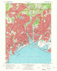 1970 Bridgeport1972 Print · USGSCoastal Connecticut thrived during the post-war era as industrial hubs expanded into modern suburban corridors. Genealogists and historians can trace neighborhood growth through dozens of sites like Mount Grove Cemetery, Sacred Heart University, and the Bridgeport Municipal Airport.4 unique versions available
 - 1970 Map of Bethel, 1973 Print
 1970 Bethel1973 Print · USGSFairfield County towns like Bethel and Redding are shown in the early seventies, balancing industrial roots with growing suburban neighborhoods. Genealogists can trace family landmarks and sites like Umpawaug Cemetery, St Andrews Ch, and the Penn Central rail line.3 unique versions available
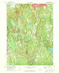
 - 1971 Map of West Granville, 1973 Print
 1971 West Granville1973 Print · USGSThe Massachusetts and Connecticut borderlands are captured here in the early 1970s, featuring the expansive waters of the Farmington River Reservoir. Local historians can trace old mountain roads and sites like West Granville, Woodland Cem, and Baird Four Corners.6 unique versions available
 - 1972 Map of Southwick, 1974 Print
 1972 Southwick1974 Print · USGSThe borderlands of Southwick and Granville are captured here in the early 1970s, showcasing a landscape of glacial lakes and steep mountain ridges. You can trace the historic lakefront at Congamond Lakes, find local schools like Powder Mill Sch, and locate old burial grounds including Northeast Cem.4 unique versions available
 - 1975 Map of Ashley Falls, 1981 Print
 1975 Ashley Falls1981 Print · USGSThe Berkshire valley on the Connecticut border is shown in the mid-1970s, revealing the intricate meanders of the Housatonic River. Trace the rural road networks and field patterns connecting Ashley Falls, Sheffield, and Clayton.
 - 1975 Map of Springfield South, 1981 Print
 1975 Springfield South1981 Print · USGSThe Pioneer Valley comes into sharp focus during the mid-1970s, showing the industrial and residential growth along the Connecticut River. Researchers can trace the mid-century footprints of Springfield, West Springfield, and Thompsonville through high-resolution aerial imagery.
 - 1975 Map of Tolland Center, 1981 Print
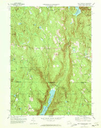
 1975 Tolland Center1981 Print · USGSThe Massachusetts-Connecticut borderlands appear in sharp detail during the mid-1970s, focused on the river valleys of the Berkshire highlands. Local historians can trace old road alignments and property boundaries near Tolland Center, New Boston, and the waters of Colebrook River Lake.
 - 1975 Map of Southbridge, 1981 Print
 1975 Southbridge1981 Print · USGSThe Quinebaug River valley and its surrounding mill towns appear in sharp photographic detail during the mid-seventies. Trace local history through the streets of Southbridge and the outlying settlements of Sturbridge and Sherman Corner.
 - 1975 Map of Bashbish Falls, 1981 Print
 1975 Bashbish Falls1981 Print · USGSThe tri-state border region comes into focus in the mid-1970s through this aerial orthophotograph of the Berkshires. Researchers can trace the layout of small communities like Joyceville and Taconic against the heights of Mt Everett and Bear Mtn.
 - 1975 Map of South Sandisfield, 1981 Print
 1975 South Sandisfield1981 Print · USGSThe southern Berkshire highlands appear in high detail during the mid-seventies in this photographic survey of the Massachusetts-Connecticut border. Trace the rural crossroads of Southfield and Montville or follow the course of the Blackberry River.
 - 1975 Map of Webster, 1981 Print
 1975 Webster1981 Print · USGSThe industrial corridor of the Massachusetts-Connecticut border is shown in great detail during the mid-seventies. Trace the footprints of mill-town history in Webster and Dudley, or locate riverfront sites in Perryville and Quinebaug.
 - 1975 Map of West Springfield, 1981 Print
 1975 West Springfield1981 Print · USGSHampden County's landscape in the mid-seventies is captured in this detailed aerial study of the Connecticut River Valley. Researchers can trace land use around Provin Mountain and locate community hubs like Hosmer Corner and West Agawam.
 - 1975 Map of Monson, 1981 Print
 1975 Monson1981 Print · USGSCovers Connecticut, including Stafford, Monson, and other nearby areas
 - 1975 Map of Hampden, 1981 Print
 1975 Hampden1981 Print · USGSThe Massachusetts-Connecticut borderlands appear in sharp detail in the mid-1970s, showcasing the transition from valley to upland. Trace property lines and land use across the Wilbraham Mountains and through settlements like Baptist Village and Hampden.
 - 1975 Map of West Granville, 1981 Print
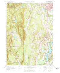
 1975 West Granville1981 Print · USGSThe Massachusetts and Connecticut borderlands appear in sharp detail in the mid-1970s, before modern development further altered the rural landscape. Researchers can trace historic crossroads at Baird Four Corners and examine the massive footprints of Cobble Mountain Reservoir and West Granville.
 - 1975 Map of Oxford, 1981 Print
 1975 Oxford1981 Print · USGSSouthern Worcester County in the mid-seventies is captured here via detailed aerial imagery. Researchers can trace the shoreline of Lake Chaubunagungamaug or survey the dense canopy of Douglas Woods and the village of Manchaug.
 - 1975 Map of Wales, 1981 Print
 1975 Wales1981 Print · USGSThe hills of Hampden County and the Connecticut border are captured in the mid-seventies, showing a landscape defined by water and woods. Genealogists and historians can trace shoreline developments at Hamilton Reservoir and the small-town layouts of Wales and Holland.
 - 1976 Map of Southwick, 1981 Print
 1976 Southwick1981 Print · USGSThe Massachusetts-Connecticut borderlands are captured in detail during the mid-seventies, showing the agricultural and residential patterns of the day. Genealogists and local historians can trace family properties and land use near Southwick, Gillett Corner, and the Congamond Lakes.
End of results
Showing maps 1-18 of 18
Top cities of Connecticut
- Bridgeport historical maps
- Stamford historical maps
- Hartford historical maps
- New Haven historical maps
- Waterbury historical maps
- Norwalk historical maps
See more
Frequently asked questions
- What are the different types of historical maps available for Connecticut?
- What is the oldest map of Connecticut?
- Where can I purchase historical maps of Connecticut for my home or office?
- Where can I download high-res historical maps of Connecticut?
- Are there historical topographic maps available for Connecticut?
- Is there historical aerial imagery available for Connecticut?
- Where are historical maps of Connecticut sourced from?