1950s Maps of Connecticut
Explore 154 historic maps of Connecticut from the 1950s. These maps offer a rare glimpse into what life looked like during the 1950s — showing old roads, neighborhoods, homes, and landmarks that have changed or disappeared over time.
Whether you're researching your family's past, planning a metal detecting trip, or studying how Connecticut's landscape evolved across the 1950s, these high-resolution maps are a powerful tool for exploring the history of this region.
- Focus on a specific era: All maps on this page are from the 1950s, giving you a focused view of this time period.
- See what’s changed: Compare century-old streets, trails, and buildings to today's modern landscape using overlays and satellite layers.
- Research with precision: Use these maps for genealogy, historical research, land use analysis, or educational projects.
- View, download, or print: Maps are fully viewable online in high resolution, and can be downloaded or printed for your own records.
Start exploring Connecticut's history through authentic maps from the 1950s. This is your window into the past.
Connecticut maps
(154)- 1950 Map of East Killingly
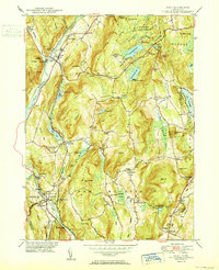
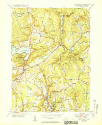
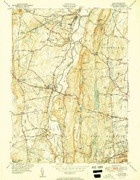
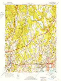
 1950 East Killingly1950 Print · USGSThe Connecticut and Rhode Island borderlands are captured here during the 1940s, showing a landscape of upland ridges and industrial brooks. You can trace early schoolhouse locations like Titus Sch and remote burial grounds including Hopkins Cem and Fiske Cem.
 - 1950 Map of Kent
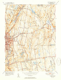
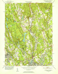
 1950 Kent1950 Print · USGSWestern Connecticut's river valleys and ridgelines are captured here at mid-century, following the winding Housatonic River. Researchers can trace the New York New Haven and Hartford RR through Gaylordsville or locate Bulls Bridge and Kent Furnace.2 unique versions available
 - 1950 Map of Sharon
 1950 Sharon1950 Print · USGSLitchfield County’s corner of the Northwest Hills was a landscape of boarding schools and iron-industry remnants in the mid-twentieth century. Researchers can trace the grounds of The Hotchkiss Sch or explore old village sites like Lime Rock and Ore Hill.2 unique versions available
 - 1950 Map of Cornwall
 1950 Cornwall1950 Print · USGSLitchfield County's upland terrain is captured here in the mid-twentieth century, centered on the historic villages and forested ridges of Cornwall and Goshen. Researchers can locate numerous family burial grounds like Allen Cem and Cornwall Cem, or trace the path of the Appalachian Trail as it crossed Dudleytown Hill.2 unique versions available
 - 1950 Map of South Canaan
 1950 South Canaan1950 Print · USGSLitchfield County highland life in the late 1940s is centered here on the rugged ridges of the Housatonic State Forest and the Housatonic River valley. Genealogists and hikers can trace the Appalachian Trail past family landmarks like Under Mountain Cem and Cornwall Hollow.3 unique versions available
 - 1950 Map of New Preston
 1950 New Preston1950 Print · USGSLitchfield County's upland terrain is captured here at mid-century, featuring the established summer colonies and rural hamlets of the southern Berkshires. Researchers can trace historic property lines near Lake Waramaug or locate local landmarks like the Gunnery Sch and Washington Depot.2 unique versions available
 - 1950 Map of Litchfield
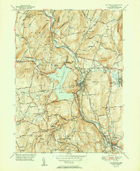
 1950 Litchfield1950 Print · USGSLitchfield County's lake-and-reservoir landscape is meticulously captured here mid-century, showing the early infrastructure of the southern Berkshires. Trace the shores of Bantam Lake or locate ancestral sites like Old Bethlehem Cem and the village of East Morris.2 unique versions available
 - 1950 Map of Woodbury
 1950 Woodbury1950 Print · USGSWoodbury and Watertown are captured in the late 1940s, showing a Connecticut landscape of river valleys and institutional landmarks. Researchers can trace historic cemeteries like North Cem and school grounds such as Taft Sch near Lake Quassapaug.2 unique versions available
 - 1950 Map of Ellsworth
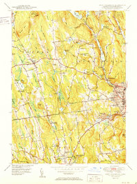
 1950 Ellsworth1950 Print · USGSLitchfield County's upland farms and river valleys are captured here at the mid-century, before the post-war era transformed the Connecticut countryside. Genealogists and hikers can trace the Appalachian Trail across Calebs Peak or locate family plots at Skiff Mtn Cem and Calhoun Cem.2 unique versions available
 - 1951 Map of Tariffville
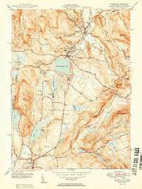
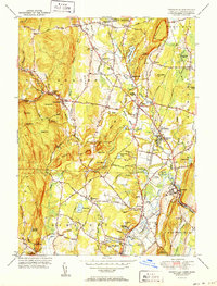 1951 Tariffville1951 Print · USGSNorth-central Connecticut thrives at the intersection of rail and river just after the war. You can trace family roots at Copper Hill Ch or locate the old Granby Station and Simsbury Landing Field.2 unique versions available
 - 1951 Map of Thomaston
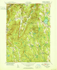
 1951 Thomaston1951 Print · USGSMid-century Litchfield County unfolds along the industrial Naugatuck valley and the rising Litchfield Hills during a period of steady growth. Genealogists and historians can locate numerous family burial grounds including Allentown Cem, trace the New York New Haven and Hartford rail lines, or find the Leatherman Cave.2 unique versions available
 - 1951 Map of Winsted
 1951 Winsted1951 Print · USGSLitchfield County's industrial valleys and summer camps are captured here in the early fifties. Genealogists and historians can trace the New York New Haven and Hartford rail corridor or locate The Little Red Schoolhouse and Barkhamsted Lighthouse.2 unique versions available
 - 1951 Map of Torrington
 1951 Torrington1951 Print · USGSTorrington and Harwinton appear at a mid-century peak of industrial activity and rural transition. Genealogists can trace family names at Hillside Cemetery, locate the old Harwinton Sch, or find local landmarks like Turtle Rock.2 unique versions available
 - 1951 Map of New Hartford
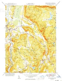
 1951 New Hartford1951 Print · USGSLitchfield and Hartford Counties appear here in the early fifties, centered on the massive Barkhamsted Reservoir and Saville Dam. Researchers can locate historic sites like the Washington Hill Ch, the Riverside Cem, and the Indian Council Cave.2 unique versions available
 - 1951 Map of West Torrington
 1951 West Torrington1951 Print · USGSLitchfield County in the early fifties shows a landscape of historic hilltop farms and growing educational institutions. Trace local history at the John Browns Birthplace (Ruins) or find family roots in the Old Middle Street Cem and Newfield Cem.2 unique versions available
 - 1951 Map of Collinsville
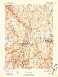
 1951 Collinsville1951 Print · USGSThe Farmington River valley in the early fifties shows a landscape of growing reservoirs and busy rail lines. Trace family roots at Collinsville, find the State Fish Hatchery, or locate old schools like Lovely Street Sch.2 unique versions available
 - 1951 Map of Lyme
 1951 Lyme1951 Print · USGSThe Connecticut shoreline at the start of the fifties shows a transition from quiet rural hills to bustling beach colonies. Trace family roots and local history at the Duck River Cem, Lynde Pt Lighthouse, and the Lyme Sta railroad stop.2 unique versions available
 - 1951 Map of Avon
 1951 Avon1951 Print · USGSMid-century Hartford County reveals a landscape of ridge-top landmarks and valley settlements along the Farmington River. Trace the grounds of the Avon Old Farms School, locate the Heublein Tower, and find family history at Cider Brook Cemetery.2 unique versions available
 - 1951 Map of Waterbury
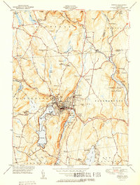
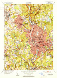 1951 Waterbury1951 Print · USGSMid-century New Haven County is captured here at a moment of dense urban growth and industrial activity along the Naugatuck River. Genealogists and researchers can pinpoint family landmarks from Riverside Cemetery to the Brookside Home for the Aged and numerous parochial and public schools.2 unique versions available
 - 1951 Map of New Milford
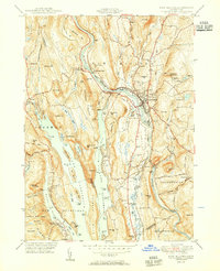 1951 New Milford1951 Print · USGSLitchfield County's river valleys and reservoirs are captured here in the early fifties, showing the area's transition into a regional recreation hub. Trace the heritage of New Milford and Sherman through landmarks like the Lime Kiln, Candlewood Cave, and the Boardman Sch.2 unique versions available
 - 1951 Map of Norfolk
 1951 Norfolk1951 Print · USGSThe Litchfield County foothills in the early fifties show a quiet landscape of mountain parks and scattered farmsteads. Researchers can trace old family burial grounds like Grantville Cem and find vanished rural nodes like the Winchester Center PO.2 unique versions available
 - 1951 Map of Woodmont, 1952 Print
 1951 Woodmont1952 Print · USGSThe Connecticut coast in the early fifties shows a burgeoning network of summer colonies and suburban expansions. Trace local history through landmarks like Savin Rock, Woodmont, and the historic New Haven Lighthouse.2 unique versions available
 - 1951 Map of Westport, 1952 Print
 1951 Westport1952 Print · USGSFairfield and Westport appear here in the early fifties, showing a refined coastal landscape of established estates and watershed reservoirs. Genealogists and researchers can locate several burial grounds, including Gilbertown Cem and Old West Cem, alongside early academic sites like Fairfield University.5 unique versions available
 - 1951 Map of Norwalk North, 1952 Print
 1951 Norwalk North1952 Print · USGSFairfield County towns like Norwalk and Wilton are shown in the early fifties during a period of steady suburban expansion. Genealogists can locate family landmarks like Bald Hill Cem, Hurlbutt Sch, and the old Winnipauk Mill Pond.4 unique versions available
 - 1951 Map of Sherwood Point, 1952 Print
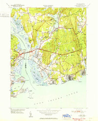
 1951 Sherwood Point1952 Print · USGSThe Connecticut coast at the start of the 1950s shows a landscape of growing seaside neighborhoods and maritime heritage. Genealogists and local historians can trace family-named landmarks from Hale Court and Compo Hills to the shores of Sherwood Millpond.4 unique versions available
Showing maps 1-25 of 154
Top cities of Connecticut
- Bridgeport historical maps
- Stamford historical maps
- Hartford historical maps
- New Haven historical maps
- Waterbury historical maps
- Norwalk historical maps
See more
Frequently asked questions
- What are the different types of historical maps available for Connecticut?
- What is the oldest map of Connecticut?
- Where can I purchase historical maps of Connecticut for my home or office?
- Where can I download high-res historical maps of Connecticut?
- Are there historical topographic maps available for Connecticut?
- Is there historical aerial imagery available for Connecticut?
- Where are historical maps of Connecticut sourced from?