1900-1909 Maps of Connecticut
Explore 18 historic maps of Connecticut from 1900-1909. These maps offer a rare glimpse into what life looked like during the 1900s — showing old roads, neighborhoods, homes, and landmarks that have changed or disappeared over time.
Whether you're researching your family's past, planning a metal detecting trip, or studying how Connecticut's landscape evolved across the 1900s, these high-resolution maps are a powerful tool for exploring the history of this region.
- Focus on a specific era: All maps on this page are from the 1900s, giving you a focused view of this time period.
- See what’s changed: Compare century-old streets, trails, and buildings to today's modern landscape using overlays and satellite layers.
- Research with precision: Use these maps for genealogy, historical research, land use analysis, or educational projects.
- View, download, or print: Maps are fully viewable online in high resolution, and can be downloaded or printed for your own records.
Start exploring Connecticut's history through authentic maps from the 1900s. This is your window into the past.
Connecticut maps
(18)- 1900 Map of Housatonic
 1900 Housatonic1900 Print · USGSThe Berkshires and the Housatonic Valley are captured here at a moment of industrial and social transition during the late Victorian era. Genealogists and historians can trace the early rail networks of the Boston and Albany R.R. through old settlements like Shaker Village and Lenox Furnace.5 unique versions available
 - 1900 Map of Oyster Bay
 1900 Oyster Bay1900 Print · USGSThe North Shore of Long Island is captured at the turn of the century as its maritime villages and sprawling estates began to transition into refined commuter suburbs. Genealogists can trace property and neighborhood development in Sea Cliff, Glen Cove, and Oyster Bay before the automobile era.15 unique versions available
 - 1901 Map of Clove
 1901 Clove1901 Print · USGSDutchess County and the Connecticut borderlands are captured here at the close of the nineteenth century as the rail corridors began to shape local commerce. Genealogists can trace family holdings and old junctions from Dover Plains to Stormville and Moores Mill.11 unique versions available
 - 1901 Map of Holyoke
 1901 Holyoke1901 Print · USGSThe Pioneer Valley and surrounding highlands thrive at the turn of the century, showing a landscape defined by mill towns and early rail networks. Genealogists and historians can trace old homesteads and local landmarks like Bisbee Mill, South Ferry, and the Agricultural College.4 unique versions available
 - 1901 Map of Northport, 1962 Print
 1901 Northport1962 Print · USGSThe North Shore of Long Island is captured here at the turn of the century, showing a landscape defined by deep harbors and maritime navigation. You can trace the early rail routes of the Long Island RR and locate historic coastal landmarks like Eatons Neck L.H. and Fort Salonga.
 - 1902 Map of Millbrook
 1902 Millbrook1902 Print · USGSEastern Dutchess County at the turn of the century was a bustling corridor of intersecting railroads and valley settlements. Genealogists and rail historians can trace the paths of the Central New England R. R. and find local landmarks like Lithgow, Shekomeko, and Hammertown.10 unique versions available
 - 1903 Map of Cornwall
 1903 Cornwall1903 Print · USGSNorthwestern Connecticut at the dawn of the twentieth century shows a landscape of iron-mining hamlets and river-valley rail lines. Genealogists and historians can trace the foundations of Ore Hill, the streets of Salisbury, and the path of the Central New England RR.9 unique versions available
 - 1903 Map of Northport
 1903 Northport1903 Print · USGSThe North Shore of Long Island at the turn of the century reveals a landscape defined by deep harbors and the expanding railroad. Genealogists and historians can trace the early layouts of Northport and Huntington, or locate landmarks like Eaton Neck L.H. and Kings Park.8 unique versions available
 - 1903 Map of Gardiners Island, 1962 Print
 1903 Gardiners Island1962 Print · USGSThe eastern reaches of Long Island and its surrounding sounds appear here at the opening of the twentieth century. Researchers can trace historic shorelines and maritime infrastructure, including Fort Terry on Plum Island and old settlements like Kingstown and Fireplace.
 - 1904 Map of New Milford
 1904 New Milford1904 Print · USGSLitchfield County at the close of the nineteenth century is defined by the industrial valleys of the Housatonic River and the rural reaches of Washington. Researchers can trace the era's infrastructure through landmarks like Kent Furnace, the Berkshire Division rail line, and the village at Roxbury Station.8 unique versions available
 - 1904 Map of Waterbury
 1904 Waterbury1904 Print · USGSThe Naugatuck River valley's industrial peak and the surrounding Litchfield Hills are captured here at the start of the twentieth century. Researchers can trace the early rail networks of the Naugatuck Division and find old local landmarks like Reynolds Bridge, Quassapaug Pond, and Hotchkissville.8 unique versions available
 - 1904 Map of Islip
 1904 Islip1904 Print · USGSSuffolk County at the start of the century reveals a landscape defined by deep north-shore harbors and the expansive Great South Bay. Genealogists and local historians can trace early rail lines through Kings Park and Stony Brook, or locate the sprawling State Hospital and St. Dominic Convent.5 unique versions available
 - 1904 Map of Gardiners Island
 1904 Gardiners Island1904 Print · USGSEasthampton and its outlying islands are captured here in the early twentieth century, showing a maritime landscape defined by coastal forts and small harbor landings. Genealogists and local historians can trace family-named sites like Barnes Landing, Springs, and the military outpost at Fort Terry.6 unique versions available
 - 1904 Map of Litchfield
 1904 Litchfield1904 Print · USGSThe Litchfield Hills at the turn of the century are shown here as a landscape of iron heritage and river-powered industry. Genealogists and historians can locate old industrial sites like Kent Furnace, ancestral homes near Sharon Valley, and early rail stops at Limerock Sta..3 unique versions available
 - 1906 Map of Farmington
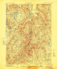
 1906 Farmington1906 Print · USGSCentral Connecticut at the turn of the century is a landscape of river-powered industry and rail-connected towns. Researchers can trace historic river crossings like Bissell Ferry and explore early village centers including Collinsville, Satans Kingdom, and Pine Meadow.2 unique versions available
 - 1907 Map of Sandisfield, 1910 Print
 1907 Sandisfield1910 Print · USGSThe Massachusetts-Connecticut borderlands appear here at the turn of the century, showing a network of river-valley hamlets and upland farms. Genealogists can trace family roots through old settlements like Sandisfield, New Boston, and Montville along the Clam River.3 unique versions available
 - 1908 Map of Quinsigamond
 1908 Quinsigamond1908 Print · USGSCentral Massachusetts and its bordering states are seen here in the early twentieth century as industry and transit reshaped the Blackstone Valley. Genealogists and historians can trace the early footprints of Worcester, the expansion of the Wachusett Reservoir, and rail lines like the Boston and Albany Railroad.3 unique versions available
 - 1908 Map of Ware
 1908 Ware1908 Print · USGSCentral Massachusetts at the turn of the century reveals the Swift River Valley decades before the Quabbin Reservoir changed the landscape forever. Trace the lost footprints of Enfield and Dana, or follow the Central Vermont RR through Greenwich Village and Ware.2 unique versions available
End of results
Showing maps 1-18 of 18
Top cities of Connecticut
- Bridgeport historical maps
- Stamford historical maps
- Hartford historical maps
- New Haven historical maps
- Waterbury historical maps
- Norwalk historical maps
See more
Frequently asked questions
- What are the different types of historical maps available for Connecticut?
- What is the oldest map of Connecticut?
- Where can I purchase historical maps of Connecticut for my home or office?
- Where can I download high-res historical maps of Connecticut?
- Are there historical topographic maps available for Connecticut?
- Is there historical aerial imagery available for Connecticut?
- Where are historical maps of Connecticut sourced from?