1940s Maps of Connecticut
Explore 110 historic maps of Connecticut from the 1940s. These maps offer a rare glimpse into what life looked like during the 1940s — showing old roads, neighborhoods, homes, and landmarks that have changed or disappeared over time.
Whether you're researching your family's past, planning a metal detecting trip, or studying how Connecticut's landscape evolved across the 1940s, these high-resolution maps are a powerful tool for exploring the history of this region.
- Focus on a specific era: All maps on this page are from the 1940s, giving you a focused view of this time period.
- See what’s changed: Compare century-old streets, trails, and buildings to today's modern landscape using overlays and satellite layers.
- Research with precision: Use these maps for genealogy, historical research, land use analysis, or educational projects.
- View, download, or print: Maps are fully viewable online in high resolution, and can be downloaded or printed for your own records.
Start exploring Connecticut's history through authentic maps from the 1940s. This is your window into the past.
Connecticut maps
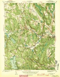
(110)- 1940 Map of Hampden
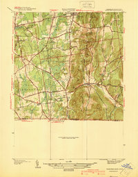 1940 Hampden1940 Print · USGSMassachusetts and Connecticut borderlands meet at the edge of the Berkshires in the late thirties. Local historians can trace old homesteads and community hubs near Baptist Village, Woodland Dell Cem, and the high peak of Minnechoag Mountain.2 unique versions available
 - 1941 Map of Uncasville
 1941 Uncasville1941 Print · USGSThe Thames River corridor is captured here in the late 1930s, showing a vital mix of naval activity, collegiate rowing traditions, and old New England hamlets. Researchers can locate dozens of family cemeteries and landmarks like the Submarine Base, the Yale Boathouse, and The Ledyard Oak.2 unique versions available
 - 1941 Map of Lyme
 1941 Lyme1941 Print · USGSThe shoreline of Old Lyme and Old Saybrook is captured here in the late 1930s as seaside communities grew alongside historic rail lines. Genealogists can locate Duck River Cem, the Bills Hill Sch, and the rail stop at Lyme Sta.2 unique versions available
 - 1942 Map of Hampden
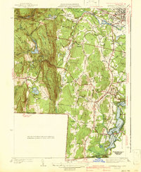
 1942 Hampden1942 Print · USGSThe Pioneer Valley foothills are captured here in the years before the war, showing the rural character of Hampden and Wilbraham. Genealogists and historians can locate family-named sites such as Adams Cem, Baptist Village, and the Stony Hill Sch.
 - 1942 Map of Southwick
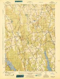
 1942 Southwick1942 Print · USGSSouthwick and the surrounding hill towns are shown here just before the mid-century, where the rail line still hugged the edge of the Congamond Lakes. Researchers can trace old family sites and local industry, from the Southwick Ch to a small Tannery and the West Parish Filters.2 unique versions available
 - 1942 Map of Ware
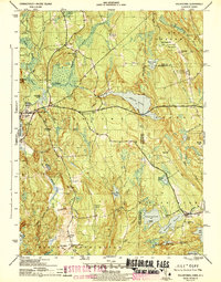
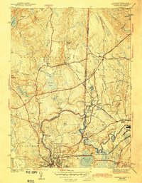
 1942 Ware1942 Print · USGSCentral Massachusetts and the Connecticut border are captured here during the early years of the war, just as the landscape was being reshaped by the Quabbin Reservoir. Researchers can trace rail-era industry and local landmarks like the Lead Mine and the Bald Peak Hospital.
 - 1942 Map of Islip, 1943 Print
 1942 Islip1943 Print · USGSCentral Suffolk County is shown during the early years of the war, as the automobile began to reshape the distance between historic North Shore harbors and the South Shore bays. Researchers can trace the path of the Long Island Motor Parkway, locate family plots at Pinelawn Cem, and identify coastal landmarks like Eaton Neck L H.
 - 1942 Map of Block Island, 1943 Print
 1942 Block Island1943 Print · USGSThe coastal borderlands of Rhode Island and Connecticut are captured here during the wartime years, documenting a landscape defined by rail and sea. Researchers can trace the NY NH & H RR through historic mill villages or locate landmarks like the Silex Mine and Indian Burying Hill.2 unique versions available
 - 1943 Map of Voluntown
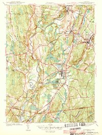
 1943 Voluntown1943 Print · USGSThe Connecticut and Rhode Island borderlands are shown here during the early 1940s, capturing the rural character of New London and Washington Counties. Researchers can trace ancestral locations at Rockville and Voluntown, or locate historic sites like Wylie Sch and the Rockville Cem.4 unique versions available
 - 1943 Map of Plainfield
 1943 Plainfield1943 Print · USGSWindham County at the height of the Second World War shows a landscape shaped by mill villages and steam-era rail lines. Genealogists and local historians can trace family locations near Plainfield Cem, Frost Sch, and the textile hubs of Wauregan and Moosup.3 unique versions available
 - 1943 Map of Fitchville
 1943 Fitchville1943 Print · USGSNew London County's rural townships and water-powered villages are captured here during the early years of the war. Genealogists and historians can trace family-named sites like Scott Hill Cem, the Central Vermont rail line, and numerous youth camps near Gardner Lake.3 unique versions available
 - 1943 Map of Brookfield
 1943 Brookfield1943 Print · USGSCentral Massachusetts at the height of the war era shows a landscape of busy rail towns and upland ponds. Genealogists and historians can trace family-named peaks like Coys Hill and old industry along the Boston and Albany RR or near Southbridge.
 - 1943 Map of Holyoke
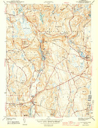
 1943 Holyoke1943 Print · USGSThe Pioneer Valley and the eastern Berkshires are captured here in the early 1940s, showing a robust network of river-side industry and hill-country forests. Researchers can locate vanished landmarks and institutional grounds like Northampton State Hospital, Barnes Airport, and the Nat Gd Rifle Range.
 - 1943 Map of Durham
 1943 Durham1943 Print · USGSMiddlesex and New Haven counties are mapped during the early years of the war, showing the rural landscapes around Durham Center. Genealogists and historians can trace family-named sites like Linmar Dairy Farm and explore the rail corridor of the New York New Haven and Hartford.
 - 1943 Map of Ashaway
 1943 Ashaway1943 Print · USGSThe Rhode Island-Connecticut borderlands during the early 1940s are defined here by textile-mill settlements and old turnpikes. Genealogists can trace family names and sites from Stillmanville to Potter Hill, including landmarks like Oak Grove Cem and St Michael Cem.2 unique versions available
 - 1943 Map of Botsford
 1943 Botsford1943 Print · USGSFairfield County towns like Botsford and Stepney appear here during the early years of the war, showcasing a landscape of ridge-top villages and new reservoirs. Genealogists and historians can trace rail connections at Botsford Sta or locate family sites near Hattertown and Redding Ridge.
 - 1943 Map of Quinsigamond
 1943 Quinsigamond1943 Print · USGSCentral Massachusetts and its bordering states appear here during the Second World War as a powerhouse of rail infrastructure and public institutions. Researchers can trace the legacy of the region through landmarks like Grafton State Hospital, the Wachusett Reservoir, and the deep industrial roots of the Blackstone River.
 - 1943 Map of Old Mystic
 1943 Old Mystic1943 Print · USGSCoastal Connecticut’s rural interior is captured here during the early war years, showing the intersection of Ledyard, Groton, and North Stonington. Genealogists can locate family landmarks such as Haleys, Burnetts Corner, and the Pequot Indian Reservation.2 unique versions available
 - 1943 Map of Housatonic
 1943 Housatonic1943 Print · USGSThe Berkshires and the Housatonic Valley are captured during the war years, showing a landscape of traditional Shaker settlements and growing industrial centers. Trace the routes of the NY NH & H RR and explore sites like Shaker Village, Richmond Furnace, and Rockdale Mills.
 - 1943 Map of Putnam, 1944 Print
 1943 Putnam1944 Print · USGSThe Connecticut and Rhode Island borderlands are captured here during the wartime era, showing a landscape defined by textile river towns and sprawling state forests. Trace the industrial rail corridor of the New York New Haven and Hartford through Putnam, Danielson, and Moosup.
 - 1943 Map of New Haven, 1947 Print
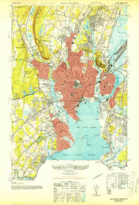 1943 New Haven1947 Print · USGSGreater New Haven at the height of the mid-forties reveals a thriving industrial port city and academic center. Researchers can trace the legacy of Yale University, locate the amusement piers of Savin Rock, and explore the shoreline from Sandy Pt to the New Haven Airport.2 unique versions available
 - 1943 Map of Norwalk North, 1947 Print
 1943 Norwalk North1947 Print · USGSFairfield County towns like Wilton and Weston are captured here during the mid-1940s as infrastructure began to modernize the valley. Researchers can trace the early path of the Merritt Parkway, find the Low-Heywood School, and locate the former Norwalk Airport.2 unique versions available
 - 1943 Map of Naugatuck, 1947 Print
 1943 Naugatuck1947 Print · USGSThe Naugatuck Valley at the height of its industrial era is captured here, tracing the river's path through the high hills of New Haven County. Researchers can locate family landmarks near Straitsville, the Seymour Reservoirs, and along the New York New Haven and Hartford rail line.2 unique versions available
 - 1943 Map of Norwalk South, 1947 Print
 1943 Norwalk South1947 Print · USGSThe Connecticut shoreline in the 1940s reveals a landscape of growing suburban towns and busy coastal rails. Trace the historic waterfronts of South Norwalk and Darien or explore offshore landmarks like Sheffield Island and Cockenoe Island.
 - 1943 Map of Brewster, 1956 Print
 1943 Brewster1956 Print · USGSThe New York and Connecticut borderlands appear here in the 1940s, showcasing a landscape defined by the Croton Watershed's massive reservoirs. Researchers can trace ancestral locations from Sodom to Milltown, or locate landmarks like Big Elm Sch and Beaver Bog Ch.2 unique versions available
Showing maps 1-25 of 110
Top cities of Connecticut
- Bridgeport historical maps
- Stamford historical maps
- Hartford historical maps
- New Haven historical maps
- Waterbury historical maps
- Norwalk historical maps
See more
Frequently asked questions
- What are the different types of historical maps available for Connecticut?
- What is the oldest map of Connecticut?
- Where can I purchase historical maps of Connecticut for my home or office?
- Where can I download high-res historical maps of Connecticut?
- Are there historical topographic maps available for Connecticut?
- Is there historical aerial imagery available for Connecticut?
- Where are historical maps of Connecticut sourced from?