1980s Maps of Connecticut
Explore 38 historic maps of Connecticut from the 1980s. These maps offer a rare glimpse into what life looked like during the 1980s — showing old roads, neighborhoods, homes, and landmarks that have changed or disappeared over time.
Whether you're researching your family's past, planning a metal detecting trip, or studying how Connecticut's landscape evolved across the 1980s, these high-resolution maps are a powerful tool for exploring the history of this region.
- Focus on a specific era: All maps on this page are from the 1980s, giving you a focused view of this time period.
- See what’s changed: Compare century-old streets, trails, and buildings to today's modern landscape using overlays and satellite layers.
- Research with precision: Use these maps for genealogy, historical research, land use analysis, or educational projects.
- View, download, or print: Maps are fully viewable online in high resolution, and can be downloaded or printed for your own records.
Start exploring Connecticut's history through authentic maps from the 1980s. This is your window into the past.
Connecticut maps
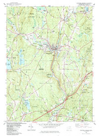
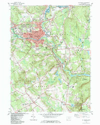
(38)- 1982 Map of Mount Kisco
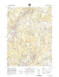 1982 Mount Kisco1982 Print · USGSNorthern Westchester County in the early eighties shows a landscape of growing village centers and preserved watershed lands. Genealogists and historians can trace institutional history and family plots at Bedford Hills Correctional Facility, Oakwood Cem, and St Mathews Ch.
 - 1982 Map of Southbridge, 1983 Print
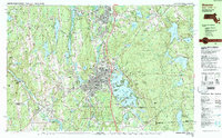
 1982 Southbridge1983 Print · USGSThe industrial Quinebaug River valley and its surrounding highlands are captured here in the early eighties as modernization reached the Massachusetts-Connecticut border. Researchers can trace family sites near St Marys Cem, navigate the ridges of Leadmine Mtn, and locate old village centers like Fiskdale and Sandersdale.2 unique versions available
 - 1982 Map of Webster, 1984 Print
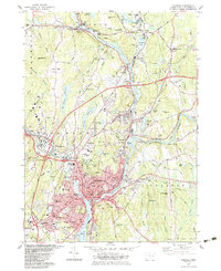
 1982 Webster1984 Print · USGSCentral Massachusetts and the tri-state borderlands come into focus in the early eighties, centered on the industrial corridors of the French River. Genealogists can trace family sites at St Anthony Cem or locate the campus of Nichols College and the various mills of Webster.2 unique versions available
 - 1983 Map of Norwich
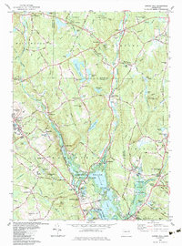
 1983 Norwich1983 Print · USGSThe industrial river valleys of New London County are shown here in the early 1980s as modern infrastructure met historic mill towns. Researchers can trace family sites at Long Society Cem, locate schools like Orchard Hill Sch, or study the rail corridors of Conrail.2 unique versions available
 - 1983 Map of Spring Hill
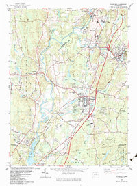
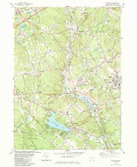
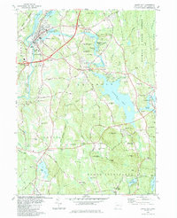
 1983 Spring Hill1983 Print · USGSTolland and Windham Counties are captured here in the early 1980s, centered on the growing campus at Storrs. Researchers can trace the layout of Mansfield Center, locate the Old Mansfield Cem, or follow the Nipmuck Trail through the valley.3 unique versions available
 - 1983 Map of Plainfield
 1983 Plainfield1983 Print · USGSThe Quinebaug River valley in the early eighties shows a landscape of industrial mill towns and expanding state forests. Trace local history through landmarks like Wauregan Station, Plainfield Greyhound Park, and several family cemeteries including Baldwin Cemetery.3 unique versions available
 - 1983 Map of Niantic
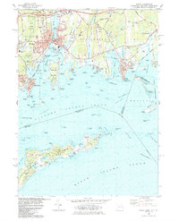
 1983 Niantic1983 Print · USGSCoastal Connecticut in the early eighties shows a landscape of beach colonies and strategic infrastructure. Researchers can trace the development of Niantic and Flanders while locating local landmarks like Stone Church, Jordan Cem, and the New London-Waterford Airport.3 unique versions available
 - 1983 Map of Montville, 1984 Print
 1983 Montville1984 Print · USGSNew London County's interior is captured here in the early eighties, showcasing a mix of suburban growth and traditional water-driven industry. Genealogists can trace family names across Noble Hill or Haines Hill, and locate local landmarks like Macks Mill and the Oakdale Sch.
 - 1983 Map of Westford, 1984 Print
 1983 Westford1984 Print · USGSNortheastern Connecticut's wooded uplands and rural hamlets are captured here in the early eighties. Researchers can locate ancestral sites like the Swamp Burying Ground, Moose Meadow Cem, and Westford Hill.
 - 1983 Map of Eastford, 1984 Print
 1983 Eastford1984 Print · USGSWindham County at the start of the eighties remains a landscape of deep forests and quiet crossroads settlements. Genealogists and hikers can trace old family burial grounds like North Ashford Cem or explore the recreational history of Crystal Pond and Lake Bungee.
 - 1983 Map of Scotland, 1984 Print
 1983 Scotland1984 Print · USGSWindham County and the surrounding uplands are captured in the early 1980s as a landscape of rural hamlets and protected forests. Researchers can trace local genealogy and land use through features like Palmertown Cem, Potash Hill Road, and the village of Hanover.
 - 1983 Map of Fitchville, 1984 Print
 1983 Fitchville1984 Print · USGSThe rural landscapes of Bozrah and Lebanon come alive in this early 1980s survey, showing a network of historic hill settlements and river valleys. Genealogists can trace family lines through New Lebanon Cem and Bozrah Cem or locate old industrial markers like the Central Vermont railroad.
 - 1983 Map of Coventry, 1984 Print
 1983 Coventry1984 Print · USGSCoventry and Tolland are captured in the early 1980s, showcasing a landscape of academic expansion and deep-rooted New England history. Genealogists and locals can trace the Nathan Hale Birthplace, Workmans Circle Cem, and the old rail corridor of the Central Vermont.2 unique versions available
 - 1983 Map of Old Mystic, 1984 Print
 1983 Old Mystic1984 Print · USGSIn the early eighties, the borderlands of Ledyard and Stonington preserved a balance of tribal lands and small New England villages. Researchers can trace family history through the Mashantucket Burial Ground, locate the old Wheeler High Sch, and follow the winding Shunock River.3 unique versions available
 - 1983 Map of Stafford Springs, 1984 Print
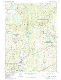
 1983 Stafford Springs1984 Print · USGSStafford Springs and its neighboring villages are shown here in the early 1980s, revealing a landscape shaped by the Willimantic River and rail transit. Trace the routes of the Central Vermont Railroad or locate family sites at Stafford St Cem and Hydeville.
 - 1983 Map of New Haven, 1985 Print
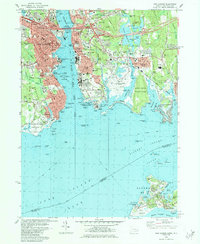
 1983 New Haven1985 Print · USGSThe Connecticut shoreline and eastern Long Island are documented here in the early eighties, from the streets of New Haven to the piers of New London. Genealogists and historians can trace the geography of maritime heritage and academia at Yale University and the U.S. Coast Guard Academy.2 unique versions available
 - 1984 Map of Willimantic
 1984 Willimantic1984 Print · USGSWillimantic and the surrounding towns of Windham and Lebanon are shown here during the mid-1980s, revealing a landscape shaped by river junctions and rail history. Genealogists can trace family names at Liberty Hill Cem or locate the historic Willimantic Camp Ground and Lyman Mem Sch.
 - 1984 Map of Block Island
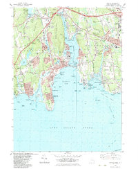
 1984 Block Island1984 Print · USGSThe coastal borderlands of Rhode Island, Connecticut, and New York are captured here in the mid-eighties, from the rail hubs of Westerly to the shores of Block Island. Genealogists and historians can trace the shoreline's evolution through landmarks like the Pequot Indian Res, New Shoreham, and Narragansett Pier.
 - 1984 Map of Uncasville
 1984 Uncasville1984 Print · USGSThe Thames River valley in the early 1980s was a hub of naval and academic activity, from the USCG Academy to the U S Naval Reservation. Genealogists and historians can trace the foundations of Gales Ferry, locate dozens of burial sites like Hebrew Cem, and find landmarks like the Norwich State Hospital.2 unique versions available
 - 1984 Map of New London
 1984 New London1984 Print · USGSThe Thames River waterfront in the mid-1980s reveals a dense network of naval history and maritime industry. Researchers can trace the grounds of the US Coast Guard Academy or locate local landmarks like Cedar Grove Cemetery and the New London Harbor Lighthouse.2 unique versions available
 - 1984 Map of Jewett City
 1984 Jewett City1984 Print · USGSJewett City and the surrounding Griswold hills appear in the mid-1980s as a landscape defined by its river-driven industry and deep woods. Researchers can trace family sites at Geer Cem or locate old crossings near Doaneville and the Pachaug Pond shoreline.3 unique versions available
 - 1984 Map of Mystic
 1984 Mystic1984 Print · USGSCoastal Connecticut and the New York borderlands meet in the mid-eighties as maritime traditions and modern development converge. Genealogists and historians can trace family plots at Elm Grove Cemetery or explore the harbor layout near Mystic Seaport and the abandoned lighthouse.2 unique versions available
 - 1984 Map of Hampton
 1984 Hampton1984 Print · USGSWindham County in the early eighties remains a landscape of deep forests and quiet crossroads. Researchers can trace historic family burial sites at Chewink Cem and North Cem or locate former hubs like Clarks Corner and Stetson Corner.
 - 1984 Map of Milford
 1984 Milford1984 Print · USGSThe Connecticut shoreline at Milford and Stratford comes to life in the mid-1980s as suburban growth meets the Sound. Trace coastal settlements like Myrtle Beach, historic sites such as Fort Trumbull, and the busy Igor Sikorsky Memorial Airport.
 - 1984 Map of Providence, 1985 Print
 1984 Providence1985 Print · USGSThe Rhode Island coast and its industrial heartlands are captured here in the mid-eighties, showing the density of the Providence metro area. Researchers can trace historic rail lines like the Providence & Worcester RR and explore the maritime layout of Narragansett Bay and Newport.
Showing maps 1-25 of 38
Top cities of Connecticut
- Bridgeport historical maps
- Stamford historical maps
- Hartford historical maps
- New Haven historical maps
- Waterbury historical maps
- Norwalk historical maps
See more
Frequently asked questions
- What are the different types of historical maps available for Connecticut?
- What is the oldest map of Connecticut?
- Where can I purchase historical maps of Connecticut for my home or office?
- Where can I download high-res historical maps of Connecticut?
- Are there historical topographic maps available for Connecticut?
- Is there historical aerial imagery available for Connecticut?
- Where are historical maps of Connecticut sourced from?