1990s Maps of Fort Defiance Agency
Explore 10 historic maps of Fort Defiance Agency from the 1990s. These maps offer a rare glimpse into what life looked like during the 1990s — showing old roads, neighborhoods, homes, and landmarks that have changed or disappeared over time.
Whether you're researching your family's past, planning a metal detecting trip, or studying how Fort Defiance Agency's landscape evolved across the 1990s, these high-resolution maps are a powerful tool for exploring the history of this region.
- Focus on a specific era: All maps on this page are from the 1990s, giving you a focused view of this time period.
- See what’s changed: Compare century-old streets, trails, and buildings to today's modern landscape using overlays and satellite layers.
- Research with precision: Use these maps for genealogy, historical research, land use analysis, or educational projects.
- View, download, or print: Maps are fully viewable online in high resolution, and can be downloaded or printed for your own records.
Start exploring Fort Defiance Agency's history through authentic maps from the 1990s. This is your window into the past.
Fort Defiance Agency maps
- 1990 Map of Low Mountain, 1991 Print
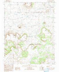
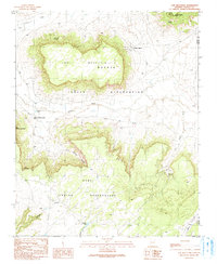 1990 Low Mountain1991 Print · USGSThe Navajo and Hopi reservations meet in the high desert of Navajo County during the late twentieth century. Researchers can trace land use through water features like Tse Chizzi Spring and high-altitude landmarks including Smoke Signal Point.
 - 1990 Map of Tsin Naan Tee, 1991 Print
 1990 Tsin Naan Tee1991 Print · USGSThe Navajo and Hopi nations meet in this high-desert plateau during the late twentieth century. Researchers can trace land use patterns through isolated features like Beshbito Wash, Tsin Naan Tee, and the Check Dams managing seasonal desert water.
 - 1991 Map of Hauke Mesa
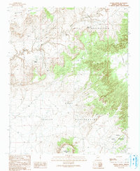
 1991 Hauke Mesa1991 Print · USGSThe borderlands of the Hopi and Navajo reservations are revealed in this late-century survey of the high desert. Researchers can trace the importance of water through landmarks like Betony Reservoir and Horse Spring, or locate remote sites including a Cemetery and scattered Graves.
 - 1991 Map of Tovar Mesa East
 1991 Tovar Mesa East1991 Print · USGSThe high plateau of Navajo County is captured here in the late twentieth century. Researchers can trace remote desert routes to Sa'lako and Tees Toh, or locate water sources like Jeddito Wash and various Water Tanks across the mesa.
 - 1991 Map of Jeddito Spring
 1991 Jeddito Spring1991 Print · USGSThe high desert landscape of the Navajo and Hopi nations is captured here in the early nineties, centered on the dramatic rise of Antelope Mesa. Genealogists and historians can locate remote water sources like Jeddito Spring and landmarks like Stephen Butte.
 - 1991 Map of White Cone
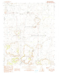 1991 White Cone1991 Print · USGSLife on the Navajo Indian Reservation in the early nineties centered on vital water sources and distinctive geological landmarks. Researchers can trace land use through White Cone Spring, the heights of White Cone Peak, and the remote Deshgish Buttes.
 - 1991 Map of Egloffstein Butte
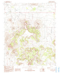
 1991 Egloffstein Butte1991 Print · USGSThe Hopi and Navajo reservations meet in this high-desert landscape during the early nineties, centered on the dramatic rise of the Hopi Buttes. Researchers can trace the community of Seba Dalkai, its Rodeo Ground, and vital water sources like Kalbitto Springs.
 - 1991 Map of Keams Canyon
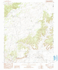
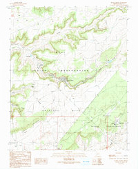 1991 Keams Canyon1991 Print · USGSNortheastern Arizona's high mesa country is captured in the 1990s as the Hopi Indian Reservation and Navajo Indian Reservation meet. Genealogists and historians can trace local life through features like the Keams Canyon settlement, the community at Jeddito, and family-named landmarks like Chili Spring.
 - 1991 Map of First Flat Mesa
 1991 First Flat Mesa1991 Print · USGSThe high mesas of the Hopi and Navajo nations are captured in the early nineties, showing a landscape defined by seasonal water and traditional boundaries. Researchers can trace the path of Ha-whi-yalin Wash or locate vital desert water at Cottonwood Spring and Coyote Spring.
 - 1991 Map of Lamb Well
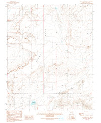
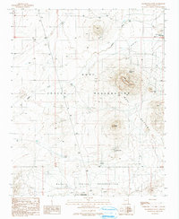
 1991 Lamb Well1991 Print · USGSThe high desert of Navajo and Apache counties comes into focus in the early 1990s, where tribal lands intersect. Trace the orientation of Antelope Mesa and find localized landmarks like Lamb Well, Keams, and the winding Jeddito Wash.
End of results
Showing maps 1-10
Top cities near Fort Defiance Agency
Top neighborhoods of Fort Defiance Agency
- Chakpahu historical maps
- Navajo historical maps
- Twin Buttes historical maps
- Naschitti historical maps
- Buffalo Springs historical maps
- Twin Lakes historical maps
See more
Frequently asked questions
- What are the different types of historical maps available for Fort Defiance Agency?
- What is the oldest map of Fort Defiance Agency?
- Where can I purchase historical maps of Fort Defiance Agency for my home or office?
- Where can I download high-res historical maps of Fort Defiance Agency?
- Are there historical topographic maps available for Fort Defiance Agency?
- Is there historical aerial imagery available for Fort Defiance Agency?
- Where are historical maps of Fort Defiance Agency sourced from?