1940s Maps of Valley County, Idaho
Explore 3 historic maps of Valley County from the 1940s. These maps offer a rare glimpse into what life looked like during the 1940s — showing old roads, neighborhoods, homes, and landmarks that have changed or disappeared over time.
Whether you're researching your family's past, planning a metal detecting trip, or studying how Valley County's landscape evolved across the 1940s, these high-resolution maps are a powerful tool for exploring the history of this region.
- Focus on a specific era: All maps on this page are from the 1940s, giving you a focused view of this time period.
- See what’s changed: Compare century-old streets, trails, and buildings to today's modern landscape using overlays and satellite layers.
- Research with precision: Use these maps for genealogy, historical research, land use analysis, or educational projects.
- View, download, or print: Maps are fully viewable online in high resolution, and can be downloaded or printed for your own records.
Start exploring Valley County's history through authentic maps from the 1940s. This is your window into the past.
Valley County, ID maps
(3)- 1942 Map of Big Creek
 1942 Big Creek1942 Print · USGSThe remote Idaho backcountry during the 1930s is revealed as a landscape of isolated cabins and active lode mines. Genealogists and historians can trace the foundations of local industry at the Golden Hand Mine, find early homesteads like Mahan Cabin, and locate the small settlement of Edwardsburg.
 - 1943 Map of Yellow Pine
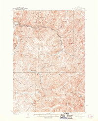 1943 Yellow Pine1943 Print · USGSThe Yellow Pine backcountry during the 1930s is revealed as a center for remote mining and forest service operations. Researchers can trace early aviation and industry through sites like Oberbilling Airport, the Stibnite outpost, and the Antimony Mine.2 unique versions available
 - 1945 Map of Riggins
 1945 Riggins1945 Print · USGSRiggins and the deep river canyons of central Idaho are captured here just before the mid-century, showing the isolated ranching and forest-service life of the era. Researchers can locate remote homesteads and outposts like Hinkley Cabin, the Middle District Sch, and Old Pollock.
End of results
Showing maps 1-3 of 3
Top cities of Valley County
Frequently asked questions
- What are the different types of historical maps available for Valley County?
- What is the oldest map of Valley County?
- Where can I purchase historical maps of Valley County for my home or office?
- Where can I download high-res historical maps of Valley County?
- Are there historical topographic maps available for Valley County?
- Is there historical aerial imagery available for Valley County?
- Where are historical maps of Valley County sourced from?