Old Maps of Valley County, Idaho for Hiking & Exploration
Hike through history with 663 historic maps of Valley County. Explore old trails, ghost towns, and forgotten backroads — perfect for outdoor adventurers and local explorers.
- Rediscover forgotten places: Map out old mining camps, roads, and footpaths that no longer exist on modern maps.
- Layer with modern tools: Combine with LiDAR or satellite views to plan hikes through historical terrain.
- Made for exploration: Popular among hikers, overlanders, and local history lovers.
Use these maps to find adventure and explore the hidden past of Valley County.
Valley County, ID maps
(663)- 1891 Map of Bear Valley, 1963 Print
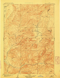
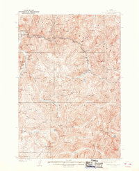
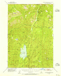
 1891 Bear Valley1963 Print · USGSThe Idaho wilderness at the close of the nineteenth century is captured here in this early reconnaissance survey. Researchers can trace the pristine headwaters of the Middle Fork Salmon River and locate historic landmarks like Stanley Lake and Tyee Mtn.
 - 1893 Map of Bear Valley
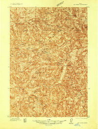
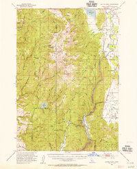
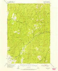
 1893 Bear Valley1893 Print · USGSCentral Idaho in the early 1890s was a wilderness of intersecting watersheds and mountain peaks long before modern infrastructure arrived. Trace the headwaters of the Salmon River and Payette River near Cape Horn and the Sawtooth Range.5 unique versions available
 - 1894 Map of Squaw Creek
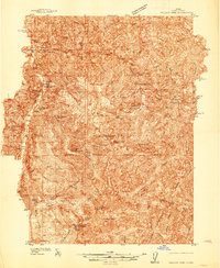
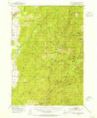
 1894 Squaw Creek1894 Print · USGSCentral Idaho in the 1890s was a landscape of mountain valleys and river crossings where early pioneers established remote outposts. Trace the locations of historic river access at Smith Ferry and early industry at Walker Mill or the settlement of Ola.5 unique versions available
 - 1909 Map of Garden Valley
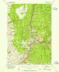
 1909 Garden Valley1909 Print · USGSThe Idaho backcountry in the late nineteenth century was a frontier of river canyons and high timber. Researchers can trace the early footprints of Lowman and Banner or follow the primitive drainages of the Deadwood River and Grimes Creek.2 unique versions available
 - 1911 Map of Meadows
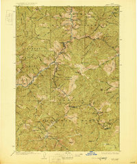
 1911 Meadows1911 Print · USGSThe high meadows and river valleys of central Idaho are seen here during the early years of the national forest system. Genealogists and historians can locate remote settlements like Lardo and Crawford, or trace rural schoolhouses including Hayes School and Rutledge School.2 unique versions available
 - 1930 Map of Casto
 1930 Casto1930 Print · USGSCentral Idaho’s rugged backcountry in the late 1920s was a land of isolated mines and family ranches. Genealogists and historians can trace high-altitude mining at the Lost Packer Mine or locate early homesteads like Falconberry Ranch and Mormon Ranch.2 unique versions available
 - 1937 Map of Yellow Pine
 1937 Yellow Pine1937 Print · USGSMining and forest management in central Idaho were in full swing during the late 1930s as this survey of the Payette National Forest was completed. Researchers can trace the layout of the Stibnite mining camp, locate the Johnston Creek Ranger Sta, and identify high-altitude outposts like the Meadow Creek Lookout.
 - 1937 Map of Big Creek
 1937 Big Creek1937 Print · USGSMid-century mining activity in the Idaho backcountry centers on the remote outposts of Edwardsburg and Big Creek. Genealogists and historians can trace lode claims like the Golden Hand Mine and Moscow Mine alongside early structures like Hand Cabin.2 unique versions available
 - 1938 Map of Riggins
 1938 Riggins1938 Print · USGSRiggins and the canyon of the Salmon River appear here in the late 1930s, showing a landscape defined by mining, ranching, and forest management. Genealogists and historians can trace family-named sites like McMillians Mine, the Black Bear Inn, and the Middle District School.2 unique versions available
 - 1942 Map of Big Creek
 1942 Big Creek1942 Print · USGSThe remote Idaho backcountry during the 1930s is revealed as a landscape of isolated cabins and active lode mines. Genealogists and historians can trace the foundations of local industry at the Golden Hand Mine, find early homesteads like Mahan Cabin, and locate the small settlement of Edwardsburg.
 - 1943 Map of Yellow Pine
 1943 Yellow Pine1943 Print · USGSThe Yellow Pine backcountry during the 1930s is revealed as a center for remote mining and forest service operations. Researchers can trace early aviation and industry through sites like Oberbilling Airport, the Stibnite outpost, and the Antimony Mine.2 unique versions available
 - 1945 Map of Riggins
 1945 Riggins1945 Print · USGSRiggins and the deep river canyons of central Idaho are captured here just before the mid-century, showing the isolated ranching and forest-service life of the era. Researchers can locate remote homesteads and outposts like Hinkley Cabin, the Middle District Sch, and Old Pollock.
 - 1953 Map of Smiths Ferry, 1955 Print
 1953 Smiths Ferry1955 Print · USGSThe Payette River valley in the early fifties was a landscape of remote rail stops and mountain lookouts. Genealogists can trace rural school locations like Lower Alpha School (Aban'd) or follow the UNION PACIFIC line through Smiths Ferry.3 unique versions available
 - 1953 Map of Boiling Springs, 1955 Print
 1953 Boiling Springs1955 Print · USGSThe Boise National Forest area in the early 1950s reveals a rugged wilderness defined by the Middle Fork Payette River. Trace historic forest service infrastructure like the Boiling Springs Guard Station and remote landmarks including Bull Creek Hot Springs and the Alpha Cemetery.3 unique versions available
 - 1953 Map of Banks, 1955 Print
 1953 Banks1955 Print · USGSThe confluence of the Payette River forks defines this mid-century survey of Boise and Valley counties. Genealogists can trace the rural mountain life of the early fifties through the High Valley Sch (Aband), Pinehurst Church, and the settlement of Banks.3 unique versions available
 - 1953 Map of Deadwood Reservoir, 1955 Print
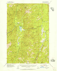
 1953 Deadwood Reservoir1955 Print · USGSThe Boise National Forest backcountry in the early fifties is mapped here in detail, centered on the newly created Deadwood Reservoir. Local historians and hikers can trace remote landmarks like the Deadwood Mine, Cupp Corral, and the Upper Deadwood Guard Station.4 unique versions available
 - 1954 Map of Gold Fork, 1956 Print
 1954 Gold Fork1956 Print · USGSValley County is captured in the mid-fifties as a landscape of national forests and high-mountain drainages. Researchers can trace the Old Railroad Grade and Old Kennedy Valley Road through settlements like Hot Spring and Crawford.3 unique versions available
 - 1954 Map of Warm Lake, 1956 Print
 1954 Warm Lake1956 Print · USGSHigh in the Boise National Forest during the mid-1950s, this area shows a landscape of fire lookouts and remote ranger stations. Researchers can trace early mining and forest service history through the Eureka Silver King Mine, Knox (Site), and the Landmark Landing Field.3 unique versions available
 - 1954 Map of Cascade, 1956 Print
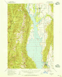 1954 Cascade1956 Print · USGSThe High Valley of the Payette River is captured here in the mid-fifties as the new reservoir redefines the landscape. Genealogists and historians can locate early settlements like Roseberry and Donnelly, the Hopps Cemetery, and high-country landmarks like Mica Mine.2 unique versions available
 - 1955 Map of Baker, 1964 Print
 1955 Baker1964 Print · USGSThe Oregon-Idaho borderlands are captured here in the mid-fifties as the Snake River underwent massive changes from dam construction. Trace the Oregon Trail Memorial Monument near Baker, find early mines like Virtue Mine, and follow the Union Pacific Railroad through Huntington.4 unique versions available
 - 1955 Map of Grangeville, 1964 Print
 1955 Grangeville1964 Print · USGSThe high country of the Idaho-Oregon border comes alive in the mid-1950s, showing the deep river canyons and mountain peaks. Trace the Union Pacific RR through the valleys or locate settlements like Grangeville, Joseph, and the shoreline of Wallowa Lake.4 unique versions available
 - 1956 Map of Elk City, 1963 Print
 1956 Elk City1963 Print · USGSThe Idaho backcountry in the mid-fifties remains a landscape of isolated mining camps and remote forest outposts. Researchers can trace historical mining operations at Stibnite Mine and Blackbird Mine or locate riverside landmarks like Mackay Bar and Campbell's Ferry.3 unique versions available
 - 1957 Map of Challis, 1964 Print
 1957 Challis1964 Print · USGSCentral Idaho in the late fifties and early sixties remains a territory of remote mining camps and high-mountain ranger stations. Trace historic mining operations like the Lucky Boy Mine or locate isolated homesteads including Robinson Bar Ranch and Allison Ranch.3 unique versions available
 - 1959 Map of Baker
 1959 Baker1959 Print · USGSThe Oregon and Idaho borderlands come alive in the late fifties, showing the rugged corridor along the Snake River and the high peaks of the Wallowa Mountains. Researchers can trace the legacy of the Union Pacific railroad or locate historic mining sites like the Flagstaff Mine and Virtue Mine.2 unique versions available
 - 1959 Map of Grangeville
 1959 Grangeville1959 Print · USGSThe high alpine peaks and deep river canyons of the Idaho-Oregon borderlands are captured in the late fifties. Researchers can trace the Union Pacific RR through the valleys to settlements like Enterprise, Union, and Grangeville.2 unique versions available
Showing maps 1-25 of 663
Top cities of Valley County
Frequently asked questions
- What are the different types of historical maps available for Valley County?
- What is the oldest map of Valley County?
- Where can I purchase historical maps of Valley County for my home or office?
- Where can I download high-res historical maps of Valley County?
- Are there historical topographic maps available for Valley County?
- Is there historical aerial imagery available for Valley County?
- Where are historical maps of Valley County sourced from?