1980s Maps of Valley County, Idaho
Explore 37 historic maps of Valley County from the 1980s. These maps offer a rare glimpse into what life looked like during the 1980s — showing old roads, neighborhoods, homes, and landmarks that have changed or disappeared over time.
Whether you're researching your family's past, planning a metal detecting trip, or studying how Valley County's landscape evolved across the 1980s, these high-resolution maps are a powerful tool for exploring the history of this region.
- Focus on a specific era: All maps on this page are from the 1980s, giving you a focused view of this time period.
- See what’s changed: Compare century-old streets, trails, and buildings to today's modern landscape using overlays and satellite layers.
- Research with precision: Use these maps for genealogy, historical research, land use analysis, or educational projects.
- View, download, or print: Maps are fully viewable online in high resolution, and can be downloaded or printed for your own records.
Start exploring Valley County's history through authentic maps from the 1980s. This is your window into the past.
Valley County, ID maps
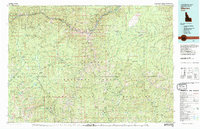
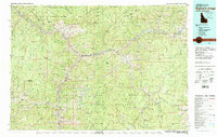
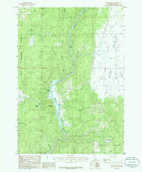
(37)- 1980 Map of McCall, 1993 Print
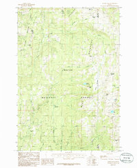
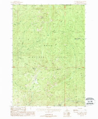
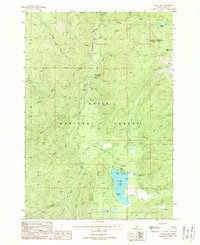
 1980 McCall1993 Print · USGSThe high timber country and glacial lakes of the West Mountains are documented here in the early eighties. Genealogists and local historians can trace the Union Pacific rail line and family-linked sites like Roseberry, Starkey, and the North Hornet Mine.2 unique versions available
 - 1980 Map of Weiser, 1993 Print
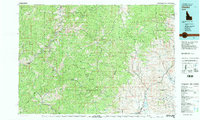
 1980 Weiser1993 Print · USGSThe Snake River valley and the foothills of the Boise Mountains are captured here in the 1980s, showing the vital rail and water infrastructure of the region. Researchers can trace the Union Pacific line through Payette or locate rural landmarks like Hog Cove Butte and Wilburn Butte.
 - 1981 Map of Warren
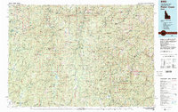
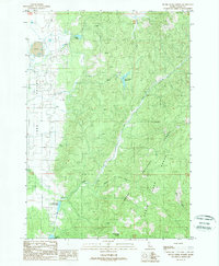
 1981 Warren1981 Print · USGSCentral Idaho’s high backcountry is revealed here in the early eighties, where isolated mining camps and wilderness boundaries met. Genealogists and historians can trace old claims like the Czizek Mine and Red Metals Mine or the remote outpost of Edwardsburg.
 - 1982 Map of Challis
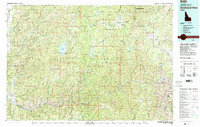
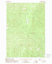
 1982 Challis1982 Print · USGSIn the early 1980s, the rugged central Idaho backcountry around Challis remained a stronghold of mining and wilderness. Researchers can trace the legacy of remote industry at the Yellowjacket Mine and locate backcountry outposts like Casto and the Boyle Landing Strip.
 - 1982 Map of Pistol Creek
 1982 Pistol Creek1982 Print · USGSThe central Idaho wilderness in the early eighties was a landscape of remote mining camps and backcountry airfields. Researchers can trace the history of mineral extraction at the Thunder Mountain Mine or locate early aviation sites like the Stibnite Landing Strip and Landmark Landing Strip.
 - 1982 Map of Deadwood River
 1982 Deadwood River1982 Print · USGSCentral Idaho in the early eighties was a vast expanse of protected wilderness and remote river canyons. Local historians and hunters can locate early landmarks like the Mary Jane Mine, the settlement of Lowman, and isolated facilities such as the Bruce Meadows Landing Strip.
 - 1982 Map of Bighorn Crags
 1982 Bighorn Crags1982 Print · USGSThe Salmon River Mountains in the early 1980s showcase a landscape where mining industry met vast new wilderness protections. Metal detectorists and local historians can trace the sites of the Blackbird Mine, the settlement of Cobalt, and the high-altitude Bighorn Crags.
 - 1985 Map of Alpha, 1986 Print
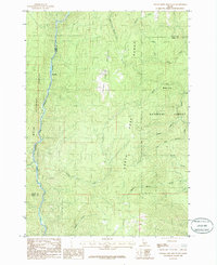
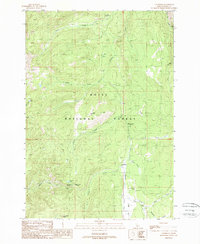
 1985 Alpha1986 Print · USGSLong Valley and the high West Mountains are documented here during the mid-eighties, showing the interface of timberlands and river bottom. Researchers can trace the river-and-rail corridor through Alpha, Cabarton, and Belvidere or locate remote sites like Shirts Lake.2 unique versions available
 - 1985 Map of Packer John Mountain, 1986 Print
 1985 Packer John Mountain1986 Print · USGSThe Boise National Forest landscape is shown here during the mid-1980s, centered on the high ridgelines of the Packer John Mountain Range. Researchers can trace the drainage systems of Scriver Creek and the river bend at Big Eddy.
 - 1985 Map of Sage Hen Reservoir, 1986 Print
 1985 Sage Hen Reservoir1986 Print · USGSThe Boise National Forest highlands are captured here in the early 1980s, centered on the Sage Hen Reservoir. Researchers can trace old forest boundaries and topographic landmarks like Tripod Summit, Timber Flat, and Antelope Swale.
 - 1985 Map of Tripod Peak, 1986 Print
 1985 Tripod Peak1986 Print · USGSThe high basins of the Boise and Payette National Forests are captured here in the mid-1980s, centered on the drainage of Squaw Creek. Researchers can locate specialized landmarks like the Snowbank Mountain radio tower, the seasonal Wilson Meadows, and the high waters of Blue Lake.
 - 1985 Map of Cold Spring Ridge, 1986 Print
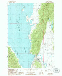
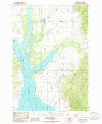
 1985 Cold Spring Ridge1986 Print · USGSThe high ridges of Adams and Valley counties are captured here in the mid-1980s, documenting a rugged interface of national forest lands and major watersheds. Outdoorsmen and historians can trace the steep terrain from Lookout Peak and Mica Saddle down to the eastern shores of the Cascade Reservoir.
 - 1985 Map of Cascade, 1986 Print
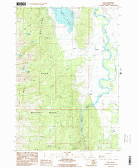
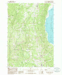
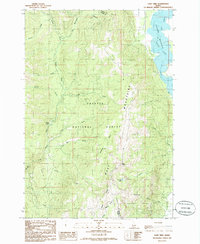
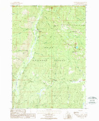
 1985 Cascade1986 Print · USGSValley County is shown in the mid-1980s as the town of Cascade sits along its namesake reservoir. Researchers can trace the Old R R Grade and locate features like the Landing Strip, Crown Point, and the Trailer Park.
 - 1985 Map of Donnelly, 1986 Print
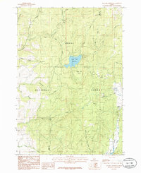
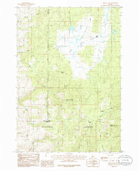
 1985 Donnelly1986 Print · USGSDonnelly and the Long Valley region are documented here in the mid-eighties as the community balanced its agricultural roots with growing lakeside recreation. Genealogists and historians can trace the Old R.R. Grade, the site of Arling Hot Spr, and the original streets of Roseberry.
 - 1985 Map of Smiths Ferry, 1986 Print
 1985 Smiths Ferry1986 Print · USGSThe North Fork Payette River corridor and the settlement of Smiths Ferry are captured here in the mid-1980s. Local researchers can trace the transition from Boise National Forest timberlands to the ranching geography of Round Valley and the Tripod Reservoir.
 - 1985 Map of Lone Tree, 1986 Print
 1985 Lone Tree1986 Print · USGSThe West Mountains of central Idaho are captured here in the mid-1980s, where the high-elevation divide separates the Payette and Weiser River watersheds. Outdoor researchers and local historians can trace the shoreline of the Cascade Reservoir and locate landmarks like Lone Tree and Poison Lake.
 - 1985 Map of High Valley, 1986 Print
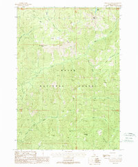
 1985 High Valley1986 Print · USGSThe high timberlands and headwaters of the Boise National Forest are captured here in the mid-eighties. Genealogists and historians can trace old forestry routes and high-country landmarks like High Valley, Dry Buck Meadow, and Ola Summit.
 - 1987 Map of Riggins
 1987 Riggins1987 Print · USGSThe Salmon and Snake River canyons defined the Idaho-Oregon borderlands in the 1980s as wilderness recreation and historic mining sites overlapped. Researchers can trace the rugged access to Riggins, find high-altitude camps near Hazard Lake, and locate the Florence Mine or Black Bear Mine.
 - 1988 Map of Gold Fork Rock
 1988 Gold Fork Rock1988 Print · USGSValley County high country is documented here in the late 1980s, showcasing the convergence of the Boise and Payette National Forests. Trace backcountry routes along the Pack Trail and locate remote landmarks like Gold Fork Rock and the Needles.
 - 1988 Map of Landmark
 1988 Landmark1988 Print · USGSThe high backcountry of Valley County is captured in the late 1980s, centering on the remote forestry outpost of Landmark. Researchers can trace the layout of Landmark USFS Airport and explore mountain landmarks like Buck Mountain, Warm Lake Summit, and Landmark Rock.
 - 1988 Map of Wild Buck Peak
 1988 Wild Buck Peak1988 Print · USGSHigh in the Salmon River mountains during the late 1980s, this area of the Boise National Forest remained a roadless wilderness. Backcountry researchers can trace the drainages of the South Fork Salmon River and map routes to summits like Wild Buck Peak or Monumental Peak.
 - 1988 Map of Bernard Mountain
 1988 Bernard Mountain1988 Print · USGSValley County mining and wilderness are documented in the late eighties as industry met preservation. Local history researchers can locate the Deadwood Mine, the Mary Jane Mine, and remote landmarks like Fin Rock or Sheepherder Lake.
 - 1988 Map of Warm Lake
 1988 Warm Lake1988 Print · USGSThe high Idaho backcountry comes alive in the late eighties near the junction of two national forests. Trace the recreation history of Warm Lake and locate old landmarks like the Warm Lake Lodge, Thunderbolt Mountain, and Paradise Valley.2 unique versions available
 - 1988 Map of Skunk Creek Summit
 1988 Skunk Creek Summit1988 Print · USGSValley County, Idaho, is documented in the late eighties as a landscape of forest management and high-altitude water storage. Local researchers can trace community landmarks like Alpha Cemetery and Grange Hall alongside the Strip Mine and various reservoirs.
 - 1988 Map of Rice Peak
 1988 Rice Peak1988 Print · USGSValley County, Idaho, in the late 1980s is shown as a hub of forest management and early silver prospecting within the Boise National Forest. Researchers can trace the path of the South Fork Salmon River to find Vulcan Hot Springs or locate the site of the Eureka Silver King Mine.
Showing maps 1-25 of 37
Top cities of Valley County
Frequently asked questions
- What are the different types of historical maps available for Valley County?
- What is the oldest map of Valley County?
- Where can I purchase historical maps of Valley County for my home or office?
- Where can I download high-res historical maps of Valley County?
- Are there historical topographic maps available for Valley County?
- Is there historical aerial imagery available for Valley County?
- Where are historical maps of Valley County sourced from?