1910s Maps of Macoupin County, Illinois
Explore 3 historic maps of Macoupin County from the 1910s. These maps offer a rare glimpse into what life looked like during the 1910s — showing old roads, neighborhoods, homes, and landmarks that have changed or disappeared over time.
Whether you're researching your family's past, planning a metal detecting trip, or studying how Macoupin County's landscape evolved across the 1910s, these high-resolution maps are a powerful tool for exploring the history of this region.
- Focus on a specific era: All maps on this page are from the 1910s, giving you a focused view of this time period.
- See what’s changed: Compare century-old streets, trails, and buildings to today's modern landscape using overlays and satellite layers.
- Research with precision: Use these maps for genealogy, historical research, land use analysis, or educational projects.
- View, download, or print: Maps are fully viewable online in high resolution, and can be downloaded or printed for your own records.
Start exploring Macoupin County's history through authentic maps from the 1910s. This is your window into the past.
Macoupin County, IL maps
(3)- 1912 Map of Gillespie, 1971 Print
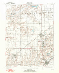 1912 Gillespie1971 Print · USGSMacoupin County at the height of its mining and rail era reveals a landscape of industrial towns and dense rural school districts. Genealogists and historians can trace numerous named institutions like Spanish Needle School, the Wayne Cem, and coal operations like Mine No 7.
 - 1915 Map of Gillespie
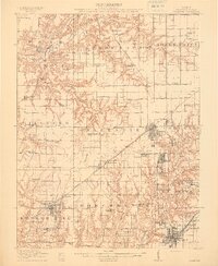 1915 Gillespie1915 Print · USGSMacoupin County at the height of its coal-mining era is detailed here, showing a landscape defined by rail junctions and small mining towns. Genealogists and historians can trace defunct schoolhouses like Spanish Needle School and rural landmarks such as Corrington Chapel or the Coal Washer.3 unique versions available
 - 1915 Map of Mount Olive
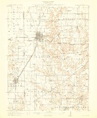 1915 Mount Olive1915 Print · USGSCentral Illinois at the height of the steam era reveals a landscape shaped by competing railroads and dense rural school districts. Genealogists can trace family footprints through numerous local landmarks like Ritchie School, Robbs Mound, and the many lines of the Illinois Traction.3 unique versions available
End of results
Showing maps 1-3 of 3
Top cities of Macoupin County
- Carlinville historical maps
- Staunton historical maps
- Virden historical maps
- Gillespie historical maps
- Girard historical maps
- Mount Olive historical maps
See more
Frequently asked questions
- What are the different types of historical maps available for Macoupin County?
- What is the oldest map of Macoupin County?
- Where can I purchase historical maps of Macoupin County for my home or office?
- Where can I download high-res historical maps of Macoupin County?
- Are there historical topographic maps available for Macoupin County?
- Is there historical aerial imagery available for Macoupin County?
- Where are historical maps of Macoupin County sourced from?