1950s Maps of Macoupin County, Illinois
Explore 10 historic maps of Macoupin County from the 1950s. These maps offer a rare glimpse into what life looked like during the 1950s — showing old roads, neighborhoods, homes, and landmarks that have changed or disappeared over time.
Whether you're researching your family's past, planning a metal detecting trip, or studying how Macoupin County's landscape evolved across the 1950s, these high-resolution maps are a powerful tool for exploring the history of this region.
- Focus on a specific era: All maps on this page are from the 1950s, giving you a focused view of this time period.
- See what’s changed: Compare century-old streets, trails, and buildings to today's modern landscape using overlays and satellite layers.
- Research with precision: Use these maps for genealogy, historical research, land use analysis, or educational projects.
- View, download, or print: Maps are fully viewable online in high resolution, and can be downloaded or printed for your own records.
Start exploring Macoupin County's history through authentic maps from the 1950s. This is your window into the past.
Macoupin County, IL maps
(10)- 1950 Map of Alton
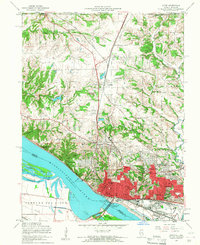
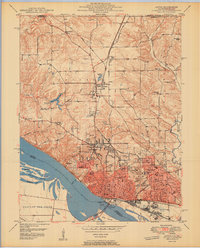 1950 Alton1950 Print · USGSAlton was a bustling river and rail hub at the mid-century, defined by its educational institutions and heavy river infrastructure. Trace the old campus of Western Military Academy, the riverfront at Lock and Dam No 26, and cemeteries like Confederate Cem.2 unique versions available
 - 1954 Map of Worden, 1959 Print
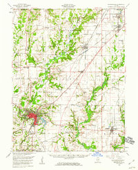
 1954 Worden1959 Print · USGSThe Madison County coal and rail belt is captured here in the mid-fifties, showing the industrial heart of Worden and Livingston. Genealogists can trace family footprints at New Hope Cem and rural schools like Hazel Dell Sch and Moultonville Sch.4 unique versions available
 - 1954 Map of Bethalto, 1959 Print
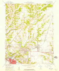 1954 Bethalto1959 Print · USGSThe industrial corridor of Madison County meets growing postwar suburbs in the mid-fifties. Researchers can locate vanished landmarks like the Mt Olive Ch (Abandoned) and Hines Sch (Abandoned) or trace the sprawling Alton State Hospital grounds.5 unique versions available
 - 1954 Map of Prairietown, 1959 Print
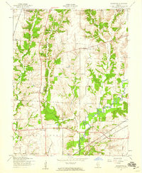 1954 Prairietown1959 Print · USGSMadison County farming communities thrive in the mid-1950s along the winding banks of Cahokia Creek. Researchers can locate numerous local landmarks like Yorkville Sch, St Johns Ch, and the Liberty Prairie Cem.3 unique versions available
 - 1954 Map of Alton, 1959 Print
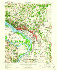
 1954 Alton1959 Print · USGSMid-century Alton and Godfrey thrive as centers of education and industry along the Mississippi. Researchers can trace the grounds of Monticello College, locate the Confederate Cem, and follow the Gulf Mobile and Ohio rail lines.4 unique versions available
 - 1954 Map of Edwardsville, 1960 Print
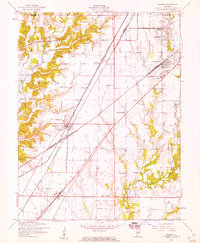
 1954 Edwardsville1960 Print · USGSMadison County in the mid-fifties reveals a landscape defined by the intersection of coal-era rail lines and expanding suburban settlements. Local historians can trace the legacy of small-town institutions like Quercus Grove Sch, the residential tracts of LeClaire, and the industrial footprint of the Mine Dump near Worden.
 - 1955 Map of Alton, 1960 Print
 1955 Alton1960 Print · USGSThe industrial riverfronts and expanding rail corridors of the Metro East are captured here in the mid-fifties. Researchers can trace the development of Alton State Hospital, the grounds of Monticello College, and historic sites like Fort Bellefontaine.2 unique versions available
 - 1956 Map of Quincy, 1967 Print
 1956 Quincy1967 Print · USGSThe river and rail corridors of the Illinois-Missouri border are documented here during the mid-1950s. Researchers can trace historic river landings and regional transit hubs from Quincy and Hannibal to smaller settlements like Meredosia and Roodhouse.3 unique versions available
 - 1958 Map of Decatur, 1971 Print
 1958 Decatur1971 Print · USGSCentral Illinois in the mid-twentieth century shows a landscape defined by industrial rail hubs and the creation of large reservoirs. Researchers can trace historic corridors like the Penn Central or locate landmarks such as Lincoln Log Cabin State Park and Lake Springfield.3 unique versions available
 - 1958 Map of Belleville, 1973 Print
 1958 Belleville1973 Print · USGSSouthern Illinois during the mid-twentieth century reveals a landscape of industrial growth and massive new reservoirs. Genealogists and historians can trace the paths of the Illinois Central RR through towns like Centralia or locate landmarks such as Emerald Mound and the Looking Glass Prairie.3 unique versions available
End of results
Showing maps 1-10 of 10
Top cities of Macoupin County
- Carlinville historical maps
- Staunton historical maps
- Virden historical maps
- Gillespie historical maps
- Girard historical maps
- Mount Olive historical maps
See more
Frequently asked questions
- What are the different types of historical maps available for Macoupin County?
- What is the oldest map of Macoupin County?
- Where can I purchase historical maps of Macoupin County for my home or office?
- Where can I download high-res historical maps of Macoupin County?
- Are there historical topographic maps available for Macoupin County?
- Is there historical aerial imagery available for Macoupin County?
- Where are historical maps of Macoupin County sourced from?