1940s Maps of Vermilion County, Illinois
Explore 4 historic maps of Vermilion County from the 1940s. These maps offer a rare glimpse into what life looked like during the 1940s — showing old roads, neighborhoods, homes, and landmarks that have changed or disappeared over time.
Whether you're researching your family's past, planning a metal detecting trip, or studying how Vermilion County's landscape evolved across the 1940s, these high-resolution maps are a powerful tool for exploring the history of this region.
- Focus on a specific era: All maps on this page are from the 1940s, giving you a focused view of this time period.
- See what’s changed: Compare century-old streets, trails, and buildings to today's modern landscape using overlays and satellite layers.
- Research with precision: Use these maps for genealogy, historical research, land use analysis, or educational projects.
- View, download, or print: Maps are fully viewable online in high resolution, and can be downloaded or printed for your own records.
Start exploring Vermilion County's history through authentic maps from the 1940s. This is your window into the past.
Vermilion County, IL maps
(4)- 1943 Map of Fithian
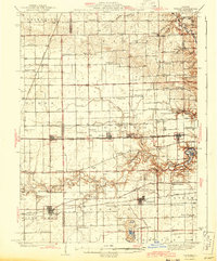 1943 Fithian1943 Print · USGSVermilion and Champaign counties come alive in the 1940s as a hub of rail travel and small-town commerce. Genealogists and historians can trace the foundations of Fithian, Fairmount, and Homer while locating rural landmarks like Little Giant Sch and Stearns Cem.2 unique versions available
 - 1947 Map of Ridge Farm
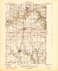 1947 Ridge Farm1947 Print · USGSEastern Illinois and the Indiana border appear here just after the war, showcasing a landscape of rail-connected towns and country school districts. Researchers can trace family history through dozens of landmarks like Scotland Sta, Vermilion Grove, and Harrison Consolidated Sch.3 unique versions available
 - 1948 Map of Danville NW, 1964 Print
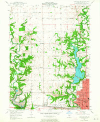 1948 Danville NW1964 Print · USGSVermilion County transitions from industrial rail hubs to rural township life shortly after the war. Researchers can trace the development of Danville neighborhoods and find family-named landmarks like Johnsonville, Bethel Ch, and the Spring Hill Cem.
 - 1949 Map of Danville SW, 1960 Print
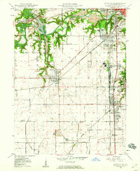 1949 Danville SW1960 Print · USGSVermilion County's coal and rail landscape is captured here in the late 1940s, showing the tight-knit mining towns southwest of Danville. Genealogists and local historians can trace family roots through sites like the Lithuanian Cem, D Day Mine, and several rural schoolhouses like Shiloh Sch.2 unique versions available
End of results
Showing maps 1-4 of 4
Top cities of Vermilion County
- Danville historical maps
- Hoopeston historical maps
- Georgetown historical maps
- Westville historical maps
- Tilton historical maps
- Catlin historical maps
See more
Frequently asked questions
- What are the different types of historical maps available for Vermilion County?
- What is the oldest map of Vermilion County?
- Where can I purchase historical maps of Vermilion County for my home or office?
- Where can I download high-res historical maps of Vermilion County?
- Are there historical topographic maps available for Vermilion County?
- Is there historical aerial imagery available for Vermilion County?
- Where are historical maps of Vermilion County sourced from?