1990s Maps of Vermilion County, Illinois
Explore 3 historic maps of Vermilion County from the 1990s. These maps offer a rare glimpse into what life looked like during the 1990s — showing old roads, neighborhoods, homes, and landmarks that have changed or disappeared over time.
Whether you're researching your family's past, planning a metal detecting trip, or studying how Vermilion County's landscape evolved across the 1990s, these high-resolution maps are a powerful tool for exploring the history of this region.
- Focus on a specific era: All maps on this page are from the 1990s, giving you a focused view of this time period.
- See what’s changed: Compare century-old streets, trails, and buildings to today's modern landscape using overlays and satellite layers.
- Research with precision: Use these maps for genealogy, historical research, land use analysis, or educational projects.
- View, download, or print: Maps are fully viewable online in high resolution, and can be downloaded or printed for your own records.
Start exploring Vermilion County's history through authentic maps from the 1990s. This is your window into the past.
Vermilion County, IL maps
(3)- 1998 Map of Sidell, 2002 Print
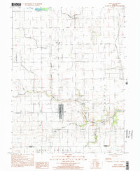 1998 Sidell2002 Print · USGSThe rural landscapes of Vermilion County are captured here just before the millennium, centered on the village of Sidell. Genealogists can locate family landmarks like Woodlawn Cem, Jamaica High Sch, and the riverside community of Archie.
 - 1998 Map of Scottland, 2002 Print
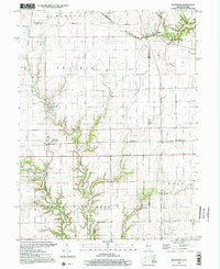 1998 Scottland2002 Print · USGSThe Illinois-Indiana state line near the end of the millennium reveals a landscape of enduring rural settlements and historic boundaries. Genealogists can locate several remote burial sites and meeting places like Old Hopewell Cem, Cameron Cem, and Wesley Chapel.
 - 1998 Map of Allerton, 2002 Print
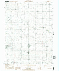 1998 Allerton2002 Print · USGSEast-central Illinois farmlands near the turn of the millennium show a landscape shaped by the Little Vermilion River and the East Branch Embarras River. Genealogists can locate Lost Grove Cem and rural landmarks like Sch No 6 or the small settlement of Hastings.
End of results
Showing maps 1-3 of 3
Top cities of Vermilion County
- Danville historical maps
- Hoopeston historical maps
- Georgetown historical maps
- Westville historical maps
- Tilton historical maps
- Catlin historical maps
See more
Frequently asked questions
- What are the different types of historical maps available for Vermilion County?
- What is the oldest map of Vermilion County?
- Where can I purchase historical maps of Vermilion County for my home or office?
- Where can I download high-res historical maps of Vermilion County?
- Are there historical topographic maps available for Vermilion County?
- Is there historical aerial imagery available for Vermilion County?
- Where are historical maps of Vermilion County sourced from?