Old Maps of Sherman County, Kansas for Hiking & Exploration
Hike through history with 160 historic maps of Sherman County. Explore old trails, ghost towns, and forgotten backroads — perfect for outdoor adventurers and local explorers.
- Rediscover forgotten places: Map out old mining camps, roads, and footpaths that no longer exist on modern maps.
- Layer with modern tools: Combine with LiDAR or satellite views to plan hikes through historical terrain.
- Made for exploration: Popular among hikers, overlanders, and local history lovers.
Use these maps to find adventure and explore the hidden past of Sherman County.
Sherman County, KS maps
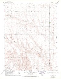
(160)- 1950 Map of Bonny Reservoir, 1952 Print
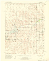 1950 Bonny Reservoir1952 Print · USGSThe high plains of the Colorado-Kansas border were undergoing a massive transformation in the early fifties with the completion of the Bonny Dam. Genealogists and local historians can locate several family-named landmarks including Burr Ranch and the Jacobs Cem, alongside long-gone schoolhouses like Happy Hollow Sch.3 unique versions available
 - 1951 Map of Bird City South
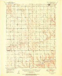 1951 Bird City South1951 Print · USGSThe northern Kansas high plains come alive in this mid-century survey of the settlements surrounding Bird City and the Cheyenne Co Sherman Co line. Researchers can trace the exact locations of rural schoolhouses and cemeteries like South Star Sch and Wheeler Cem.2 unique versions available
 - 1951 Map of Dewey Ranch, 1952 Print
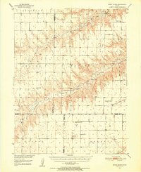 1951 Dewey Ranch1952 Print · USGSNorthwest Kansas ranching country and the Missouri River Basin development are captured here in the early fifties. Genealogists can trace rural school districts and community centers like Prairie Gem Ch, Dewey Ranch, and Pleasant Valley Sch.
 - 1952 Map of St Francis 3
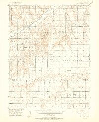 1952 St Francis 31952 Print · USGSWestern Kansas ranching and farming communities are documented here in the early fifties, centered on the river valleys of Cheyenne County. Genealogists can trace rural landmarks including Neville Ch, Battle Creek Cem, and schools like Sunny Ridge Sch.2 unique versions available
 - 1954 Map of Limon
 1954 Limon1954 Print · USGSThe Eastern Colorado plains and the Kansas borderlands come alive in the mid-fifties, showing the vital rail-and-road corridor through Limon. Genealogists and historians can trace the Chicago Rock Island & Pacific line through Burlington and find remote outposts like Arickaree and Anton.4 unique versions available
 - 1954 Map of Goodland, 1976 Print
 1954 Goodland1976 Print · USGSNorthwest Kansas comes into focus during the mid-1950s, showing a landscape defined by its vital river forks and thriving rail towns. Researchers can trace the path of the Union Pacific through Colby or locate historic parks like Sheridan Co State Park.
 - 1956 Map of Goodland
 1956 Goodland1956 Print · USGSThe high plains of Northwest Kansas in the mid-fifties reveal a landscape of river-fed agriculture and expanding rail networks. Genealogists and historians can trace the development of county seats like Goodland and Atwood or locate landmarks such as the Arikaree Breaks.
 - 1957 Map of Limon
 1957 Limon1957 Print · USGSThe High Plains of Eastern Colorado and Western Kansas come alive in the mid-1950s, showing the vital rail-and-road connections of the era. You can trace the path of the Chicago Rock Island and Pacific through towns like Limon, Stratton, and Burlington or find the early footprint of Bonny Reservoir.
 - 1957 Map of Goodland
 1957 Goodland1957 Print · USGSNorthwest Kansas in the mid-1950s shows a landscape of high plains agriculture and vital rail junctions. Researchers can trace the river-valley settlements from Goodland to Oberlin and follow the paths of the Union Pacific and Sappa Creek.2 unique versions available
 - 1958 Map of Limon
 1958 Limon1958 Print · USGSEastern Colorado and the Kansas border meet in this late-fifties study of High Plains rail and river systems. Researchers can trace the path of the Chicago Rock Island and Pacific through Limon and Burlington, or locate the Bonny Dam and Bonny Reservoir.
 - 1959 Map of Harris Draw, 1960 Print
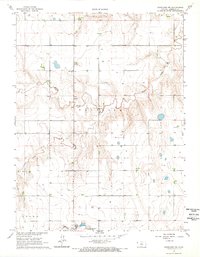
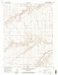
 1959 Harris Draw1960 Print · USGSThe High Plains of Western Kansas are captured here during the late fifties, showing the rural landscape along the Sherman Co and Wallace Co border. Local historians can trace early community sites like Mound School, Mt Pleasant School, and the Mennonite Cemetery.
 - 1959 Map of Horsethief Draw, 1960 Print
 1959 Horsethief Draw1960 Print · USGSThe high plains of Wallace County are captured in the late 1950s as a landscape of deep draws and seasonal rivers. Genealogists and local historians can locate rural landmarks such as Sandy Hill Sch, Fairview Cem, and the notable Horsethief Cave.2 unique versions available
 - 1966 Map of Goodland NW, 1967 Print
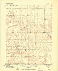
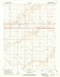
 1966 Goodland NW1967 Print · USGSSherman County during the mid-sixties shows a classic Kansas high plains landscape shaped by the Middle Fork Sappa Cr. Researchers can trace old rural infrastructure like the Prairie Star Sch and the Goodland Municipal Airport (Renner Field).2 unique versions available
 - 1966 Map of Goodland, 1967 Print
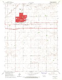 1966 Goodland1967 Print · USGSGoodland and the surrounding Sherman County plains appear here in the mid-1960s, a period of transition for High Plains travel. Researchers can trace the development of the city grid, from the Courthouse and Post Office to the interstate then UNDER CONSTRUCTION and the C R I & P railroad line.3 unique versions available
 - 1966 Map of Ruleton NW, 1967 Print
 1966 Ruleton NW1967 Print · USGSHigh Plains ranching and water management define this Sherman County landscape in the mid-sixties. Researchers can trace the path of Middle Fork Beaver Creek across Grant township or locate early industrial sites like the Sandpit.2 unique versions available
 - 1966 Map of Edson, 1967 Print
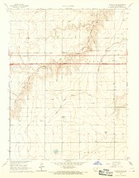
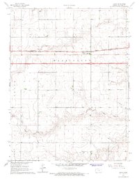 1966 Edson1967 Print · USGSSherman County life in the mid-1960s centered on the small siding of Edson as the new interstate began to reshape the plains. Genealogists and local historians can trace the Chicago Rock Island and Pacific rail line, the Edson Cem, and the headwaters of South Fork Sappa Creek.2 unique versions available
 - 1966 Map of Ruleton NE, 1967 Print
 1966 Ruleton NE1967 Print · USGSSherman County agriculture and high plains drainage are well-documented in this mid-sixties survey of the western Kansas landscape. Researchers can trace the path of Middle Fork Beaver Creek or locate the New Liberty Cem near the border of Grant township.
 - 1966 Map of Goodland NE, 1967 Print
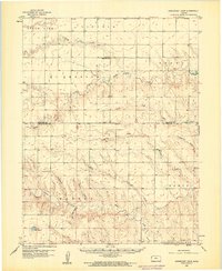
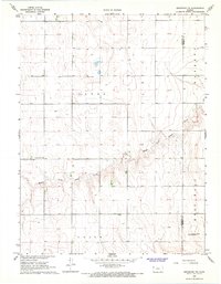
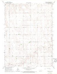 1966 Goodland NE1967 Print · USGSSherman County in the mid-1960s was a landscape of established townships and quiet prairie drainages. Genealogists and researchers can trace the section lines and watercourses of Shermanville and Voltaire or follow the path of Middle Fork Sappa Creek.
 - 1966 Map of Ruleton, 1967 Print
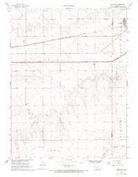
 1966 Ruleton1967 Print · USGSSherman County, Kansas, is captured during a period of infrastructure growth in the mid-1960s. Genealogists and historians can trace the development of Ruleton along the Chicago Rock Island and Pacific railroad and a highway marked Under Construction.2 unique versions available
 - 1966 Map of Ruleton SE, 1967 Print
 1966 Ruleton SE1967 Print · USGSSherman County is captured during a major transition in the mid-sixties as the interstate highway system arrives. Genealogists and historians can trace the rail-side community of Caruso and follow the route of Interstate 70 while it was still UNDER CONSTRUCTION.2 unique versions available
 - 1966 Map of Brewster NW, 1968 Print
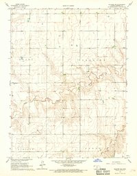
 1966 Brewster NW1968 Print · USGSThe High Plains of Sherman County are captured here in the mid-1960s, showing a landscape defined by section-line roads and the Middle Fork Sappa Creek. Genealogists and historians can locate the Pleasant Home Ch and Freeland Cem or trace the path of the Old Railroad Grade.
 - 1966 Map of Brewster, 1968 Print
 1966 Brewster1968 Print · USGSBrewster sits at the junction of rail and road during a period of high-plains modernization in the mid-sixties. Genealogists can locate Fairview Cem and trace the original path of the Chicago Rock Island and Pacific railroad.2 unique versions available
 - 1969 Map of Mc Allaster NW, 1971 Print
 1969 Mc Allaster NW1971 Print · USGSThe High Plains of western Kansas are captured here in the late sixties at the convergence of four counties. Genealogists and local researchers can trace the drainages of the South Fork Solomon River and Sand Creek near features like the spillway.
 - 1969 Map of Kanorado NE, 1972 Print
 1969 Kanorado NE1972 Print · USGSThe high plains along the Colorado and Kansas border are captured here in the late sixties, showcasing a landscape of section-line roads and prairie creek beds. Researchers can find local landmarks like the Bear Valley Cem, Bear Valley Sch, and the isolated Witzel settlement.
 - 1969 Map of Mount Sunflower NE, 1972 Print
 1969 Mount Sunflower NE1972 Print · USGSThe Colorado-Kansas state line at the edge of Kit Carson and Sherman Counties comes into focus in the late 1960s. Genealogists and local historians can trace rural development near the Green Valley Sch or follow the waters of the North Fork Smoky Hill River and Sappa Creek.
Showing maps 1-25 of 160
Top cities of Sherman County
Frequently asked questions
- What are the different types of historical maps available for Sherman County?
- What is the oldest map of Sherman County?
- Where can I purchase historical maps of Sherman County for my home or office?
- Where can I download high-res historical maps of Sherman County?
- Are there historical topographic maps available for Sherman County?
- Is there historical aerial imagery available for Sherman County?
- Where are historical maps of Sherman County sourced from?