1930s Maps of Rapides Parish, Louisiana
Explore 11 historic maps of Rapides Parish from the 1930s. These maps offer a rare glimpse into what life looked like during the 1930s — showing old roads, neighborhoods, homes, and landmarks that have changed or disappeared over time.
Whether you're researching your family's past, planning a metal detecting trip, or studying how Rapides Parish's landscape evolved across the 1930s, these high-resolution maps are a powerful tool for exploring the history of this region.
- Focus on a specific era: All maps on this page are from the 1930s, giving you a focused view of this time period.
- See what’s changed: Compare century-old streets, trails, and buildings to today's modern landscape using overlays and satellite layers.
- Research with precision: Use these maps for genealogy, historical research, land use analysis, or educational projects.
- View, download, or print: Maps are fully viewable online in high resolution, and can be downloaded or printed for your own records.
Start exploring Rapides Parish's history through authentic maps from the 1930s. This is your window into the past.
Rapides Parish, LA maps
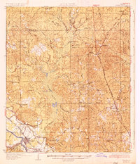
(11)- 1932 Map of Boyce NE
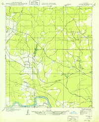 1932 Boyce NE1932 Print · USGSThe border of Grant and Rapides Parishes is captured here in the early 1930s as the national forest and river bottomlands converge. Local historians can trace family locations near Frazier Cem, Mt Pleasant Sch, and the winding banks of Rigolette Bayou.
 - 1932 Map of Boyce SW
 1932 Boyce SW1932 Print · USGSRapides Parish in the early thirties is a landscape of rural post offices and emerging federal forests. Genealogists can trace family landmarks like the Texada Cem, Wilda Po, and local country schools such as Laurel Hill Sch.
 - 1932 Map of Colfax SW
 1932 Colfax SW1932 Print · USGSThe Red River valley of Central Louisiana is captured here in the early 1930s as a landscape of rail-connected settlements and complex waterways. Genealogists and historians can trace the foundations of Colfax and locate rural landmarks like Lee Chapel, Ferenzi Ch, and the Lutesville Gravel Pit.
 - 1935 Map of Pawnee
 1935 Pawnee1935 Print · USGSCentral Louisiana's timber country is captured in the mid-1930s, showing the early infrastructure of the Rapides and Allen parish line. Researchers can trace the Logging Railroad and locate vanished landmarks like the Union Hill Sch and Bethel Cem.
 - 1935 Map of Turkey Creek
 1935 Turkey Creek1935 Print · USGSLouisiana's central parish borderlands come alive in the mid-1930s, showing a landscape defined by meandering bayous and early industrial corridors. Trace the path of the Texas Louisiana and Gulf RR or find family landmarks like Johnson Ldg and Lake Cove Sch.
 - 1935 Map of Lecompte, 1949 Print
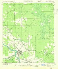
 1935 Lecompte1949 Print · USGSThe Red River valley south of Alexandria comes into focus in the mid-1930s, showing a landscape defined by meandering bayous and critical rail lines. Genealogists can locate family landmarks like Spring Hill Cem, St Johns Ch, and the town of Cheneyville.
 - 1936 Map of Colfax
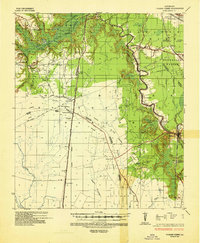
 1936 Colfax1936 Print · USGSGrant Parish in the mid-1930s is defined by the sweeping course of the Red River and the expanding reaches of Lake Iatt. Local researchers can trace old family sites and rural institutions like Parsons Cem, Summerfield, and the Oak Grove Sch.2 unique versions available
 - 1937 Map of Chopin NE
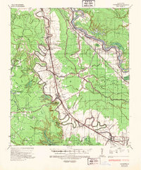
 1937 Chopin NE1937 Print · USGSThe borderlands of Natchitoches and Rapides Parishes come into focus in the late 1930s, showing a rural landscape defined by the Cane River and the Texas and Pacific railroad. Researchers can trace the exact locations of family landmarks like Carnahan Cem, Galbraith Sch, and the community of Flatwoods.
 - 1937 Map of Chopin SW
 1937 Chopin SW1937 Print · USGSThe timber-rich borderlands of Natchitoches, Rapides, and Vernon parishes are captured here in the late thirties as logging operations dominated the landscape. Researchers can trace old Logging Railroad routes and find long-established sites like Comrade Cem and Burnstown.
 - 1937 Map of Chopin NW
 1937 Chopin NW1937 Print · USGSNatchitoches and Rapides Parishes are captured here in the late 1930s as the regional timber and farming landscape was maturing. Researchers can trace rural life through the locations of Bolton Cem, Emanuel Sch, and the settlement at Gorum.
 - 1937 Map of Chopin SE
 1937 Chopin SE1937 Print · USGSThe timber country of central Louisiana comes into focus during the late Depression years, showing a landscape carved by industry. Genealogists and historians can trace the paths of the Logging Railroad and locate local landmarks like Jericho and the Clifton Sch.
End of results
Showing maps 1-11 of 11
Top cities of Rapides Parish
- Alexandria historical maps
- Pineville historical maps
- Ball historical maps
- Glenmora historical maps
- Lecompte historical maps
- Boyce historical maps
See more
Frequently asked questions
- What are the different types of historical maps available for Rapides Parish?
- What is the oldest map of Rapides Parish?
- Where can I purchase historical maps of Rapides Parish for my home or office?
- Where can I download high-res historical maps of Rapides Parish?
- Are there historical topographic maps available for Rapides Parish?
- Is there historical aerial imagery available for Rapides Parish?
- Where are historical maps of Rapides Parish sourced from?