1940s Maps of Rapides Parish, Louisiana
Explore 15 historic maps of Rapides Parish from the 1940s. These maps offer a rare glimpse into what life looked like during the 1940s — showing old roads, neighborhoods, homes, and landmarks that have changed or disappeared over time.
Whether you're researching your family's past, planning a metal detecting trip, or studying how Rapides Parish's landscape evolved across the 1940s, these high-resolution maps are a powerful tool for exploring the history of this region.
- Focus on a specific era: All maps on this page are from the 1940s, giving you a focused view of this time period.
- See what’s changed: Compare century-old streets, trails, and buildings to today's modern landscape using overlays and satellite layers.
- Research with precision: Use these maps for genealogy, historical research, land use analysis, or educational projects.
- View, download, or print: Maps are fully viewable online in high resolution, and can be downloaded or printed for your own records.
Start exploring Rapides Parish's history through authentic maps from the 1940s. This is your window into the past.
Rapides Parish, LA maps
(15)- 1940 Map of Marksville, 1943 Print
 1940 Marksville1943 Print · USGSAvoyelles Parish life in the early 1940s is centered on the river-and-rail economy of the Red River valley. Genealogists and historians can trace family locations through numerous named churches and schools, such as Hickory Hill Sch, Vick, and the St Paul Ch & Cem.2 unique versions available
 - 1941 Map of Alexandria, 1944 Print
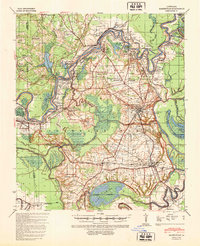
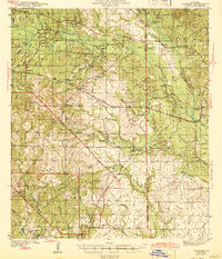
 1941 Alexandria1944 Print · USGSRapides and Grant Parishes are captured here in the early 1940s as massive military training grounds expanded alongside established rail towns. Trace the footprints of Camp Livingston and Camp Beauregard or locate local landmarks like the Philadelphia Ch and Kolin.
 - 1941 Map of Buckeye, 1944 Print
 1941 Buckeye1944 Print · USGSCentral Louisiana’s wetland and prairie interface is captured here in the early 1940s, showing the intricate water systems of the Rapides and La Salle parish lines. Genealogists can locate family landmarks like Barron Chapel, Guillory School, and the settlement of Holloway.2 unique versions available
 - 1941 Map of Boyce, 1945 Print
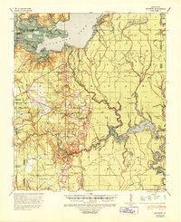
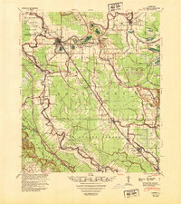
 1941 Boyce1945 Print · USGSRapides Parish was a landscape of river plantations and pine forests in the early 1940s. Genealogists and historians can locate numerous rural landmarks like Hotwells, Fairmount Plantation, and the Israelite Ch Sch & Cem along the Red River.2 unique versions available
 - 1942 Map of Oakdale, 1964 Print
 1942 Oakdale1964 Print · USGSCentral Louisiana's timber and rail country comes to life in the early 1940s as the Calcasieu River winds through Oakdale and Glenmora. Genealogists can trace family roots through landmarks like Hargrove Farm, Cryer Cem, and Cypress Creek Settlement.
 - 1943 Map of Leander
 1943 Leander1943 Print · USGSVernon and Rapides Parishes are shown in the early 1940s as the regional economy shifted from timber production to military training. Researchers can trace the Old Logging Railroad and locate vanished company centers like Fullerton or rural landmarks like Mt Moriah Ch.2 unique versions available
 - 1944 Map of Chopin
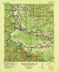
 1944 Chopin1944 Print · USGSCentral Louisiana during the early 1940s shows a landscape defined by timber harvesting and the winding Red River. Local historians can trace logging tracks and old community centers like Zimmerman Camp, Mora Ch, and Galbraith Sta.
 - 1945 Map of Boyce SE
 1945 Boyce SE1945 Print · USGSRapides Parish during the mid-forties reveals a landscape defined by its complex waterways and early transportation routes. Researchers can locate vanished landmarks and family sites near Evening Star Ch, Rapides Sch, and along the Texas and Pacific Railroad Grade.
 - 1947 Map of Steep Gully
 1947 Steep Gully1947 Print · USGSLouisiana timber and rail history converge here in the mid-1930s at the junction of Vernon, Rapides, and Allen parishes. Researchers can trace the legacy of logging via the old logging railroad grades or locate family sites at Tenmile Cem and Occupy Sch.
 - 1948 Map of Bunkie, 1950 Print
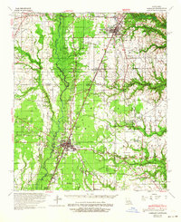
 1948 Bunkie1950 Print · USGSThe Bunkie area during the late 1940s reveals a landscape defined by Bayou Boeuf and a dense network of early oil infrastructure. Genealogists can trace family roots through numerous rural landmarks like St Lukes Ch & Cem and the Goudeau Sch.
 - 1948 Map of Chopin, 1956 Print
 1948 Chopin1956 Print · USGSLouisiana's timber and rail history comes to life in this mid-century survey of the rural backcountry spanning Natchitoches and Rapides Parishes. Researchers can trace the legacy of small communities and family-named sites like Galbraith Sta, Temple Spur, and the Blackwell Cem.
 - 1949 Map of Boyce NW
 1949 Boyce NW1949 Print · USGSThe Red River valley in the late 1940s reveals a landscape of oxbow lakes and essential rail junctions near the parish borders. Genealogists can locate family landmarks such as Zion Harp Ch, St Matthis Sch, and the small community of Zimmerman.
 - 1949 Map of Glenmora
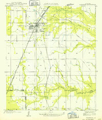 1949 Glenmora1949 Print · USGSCentral Louisiana's timber country comes to life in this mid-century survey of the Rapides Parish area. Genealogists and historians can trace the fading tracks of the Old Logging Railroad Grade and explore the early footprints of Glenmora and McNary.
 - 1949 Map of Boyce SE
 1949 Boyce SE1949 Print · USGSRapides Parish at the end of the 1940s is a landscape of winding bayous and rural schools. Researchers can trace the legacy of local communities through landmarks like Evening Star Ch, Rapides Sch, and the Red River floodplain.
 - 1949 Map of Turkey Creek, 1965 Print
 1949 Turkey Creek1965 Print · USGSEvangeline Parish during the late 1940s reveals a rural landscape of bayous and rising industry. Trace family roots at Messer Settlement or Oak Grove Cem, and locate the old rail lines of the Rock Island RR.
End of results
Showing maps 1-15 of 15
Top cities of Rapides Parish
- Alexandria historical maps
- Pineville historical maps
- Ball historical maps
- Glenmora historical maps
- Lecompte historical maps
- Boyce historical maps
See more
Frequently asked questions
- What are the different types of historical maps available for Rapides Parish?
- What is the oldest map of Rapides Parish?
- Where can I purchase historical maps of Rapides Parish for my home or office?
- Where can I download high-res historical maps of Rapides Parish?
- Are there historical topographic maps available for Rapides Parish?
- Is there historical aerial imagery available for Rapides Parish?
- Where are historical maps of Rapides Parish sourced from?