1970s Maps of Rapides Parish, Louisiana
Explore 21 historic maps of Rapides Parish from the 1970s. These maps offer a rare glimpse into what life looked like during the 1970s — showing old roads, neighborhoods, homes, and landmarks that have changed or disappeared over time.
Whether you're researching your family's past, planning a metal detecting trip, or studying how Rapides Parish's landscape evolved across the 1970s, these high-resolution maps are a powerful tool for exploring the history of this region.
- Focus on a specific era: All maps on this page are from the 1970s, giving you a focused view of this time period.
- See what’s changed: Compare century-old streets, trails, and buildings to today's modern landscape using overlays and satellite layers.
- Research with precision: Use these maps for genealogy, historical research, land use analysis, or educational projects.
- View, download, or print: Maps are fully viewable online in high resolution, and can be downloaded or printed for your own records.
Start exploring Rapides Parish's history through authentic maps from the 1970s. This is your window into the past.
Rapides Parish, LA maps
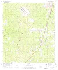
(21)- 1971 Map of Melder, 1973 Print
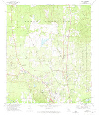
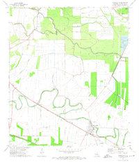
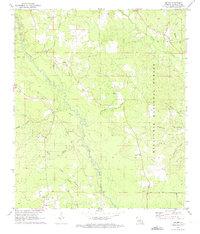 1971 Melder1973 Print · USGSRapides Parish in the early 1970s is a landscape of pine forest and river bottoms defined by the winding Calcasieu River. Researchers can trace old family roots at Stanley Cem or follow the path of the Old Railroad Grade near Melder.2 unique versions available
 - 1971 Map of Boyce, 1973 Print
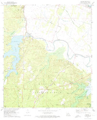
 1971 Boyce1973 Print · USGSThe Red River valley in Rapides Parish comes alive in the early seventies, showing the vital rail and river networks of Boyce and Kateland. Researchers can trace family roots at Boyce Cem or St Aloysius Cem and locate rural landmarks like Magnolia Ch and Raven Camp Ch.3 unique versions available
 - 1971 Map of Woodworth West, 1973 Print
 1971 Woodworth West1973 Print · USGSRapides Parish in the early seventies shows a landscape of dense national forest and lingering military history. Genealogists and researchers can locate Woodworth, the Camp Claiborne gunnery range, and Alexandria Memorial Gardens.2 unique versions available
 - 1971 Map of Elmer, 1973 Print
 1971 Elmer1973 Print · USGSRapides Parish was a landscape of dense timber and small rural communities during the early 1970s. You can trace family roots at St Peter Cem and Swann Cem, or locate landmarks like the Oak Hill High Sch and the Old Railroad Grade.2 unique versions available
 - 1971 Map of Forest Hill, 1974 Print
 1971 Forest Hill1974 Print · USGSRapides Parish in the early 1970s is characterized by its expansive pine forests and the logistical corridor of the Missouri Pacific Railroad. Genealogists and local historians can locate several family cemeteries and churches, including Indian Creek Cem, Butters Cem, and Elwood Ch.2 unique versions available
 - 1971 Map of Gardner, 1974 Print
 1971 Gardner1974 Print · USGSRapides Parish was undergoing significant hydrological changes in the early seventies as new reservoirs took shape across the forest. Genealogists and historians can trace several family-named landmarks and rural congregations, from Texada Cem and McNutt Cem to the Hemphill Star Ch.3 unique versions available
 - 1972 Map of Rapides, 1973 Print
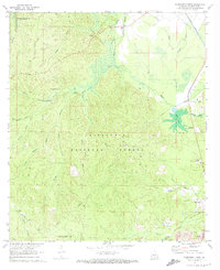
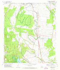
 1972 Rapides1973 Print · USGSThe Red River valley in the early seventies shows a landscape of military expansion and hydraulic engineering. Trace the growth of England Air Force Base alongside historic sites like the Central Louisiana State Hospital and St Matthews Cem.3 unique versions available
 - 1972 Map of Buckeye NE, 1974 Print
 1972 Buckeye NE1974 Print · USGSLouisiana's deltaic wetlands are caught at a crossroads of conservation and industry in the early 1970s. Trace the complex waterworks of the Catahoula Lake Diversion Canal and locate historic drilling operations at the Cypress Bayou Oil Field.2 unique versions available
 - 1972 Map of Ball, 1974 Print
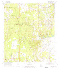
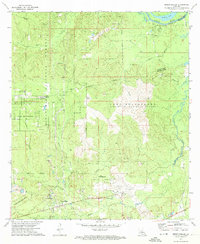
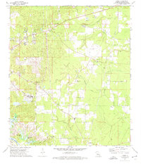
 1972 Ball1974 Print · USGSRapides and Grant Parishes are captured here in the early seventies, dominated by the pine woods of the Kisatchie National Forest. Researchers can trace the military history of Camp Beauregard or locate local landmarks like Sardis Ch and the Pollock Municipal Airport.2 unique versions available
 - 1972 Map of Rock Hill, 1974 Print
 1972 Rock Hill1974 Print · USGSGrant and Rapides Parishes are shown in the early 1970s, defined by the winding Red River and the Kisatchie National Forest. Genealogists and historians can locate family landmarks like Cruikshank Cem, Bagdad, and the Kansas City Southern rail line.2 unique versions available
 - 1972 Map of Buckeye, 1974 Print
 1972 Buckeye1974 Print · USGSCentral Louisiana's rural landscape at the start of the 1970s reveals a mix of old family settlements and emerging energy infrastructure. Genealogists and local historians can trace legacy sites like Bradford Cem, the settlement at Buckeye, and the Oil Field near Big Island.2 unique versions available
 - 1972 Map of Holloway, 1974 Print
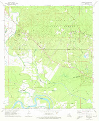
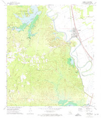
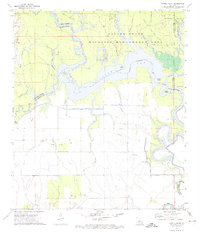
 1972 Holloway1974 Print · USGSCentral Louisiana wetlands meet industrial expansion in the early 1970s as the Little River flows into the vast Catahoula Lake. Genealogists and local historians can trace the community of Holloway, locate Marthas Chapel, or follow the Old Railroad Grade through the bayous.3 unique versions available
 - 1972 Map of Woodworth East, 1974 Print
 1972 Woodworth East1974 Print · USGSRapides Parish in the early seventies shows the expansion of southern Alexandria alongside the managed timber of the Alexander State Forest. Researchers can trace rural lineages at Oakland Ch Cem, find old rail stops at Moreland, or locate the Gravel Pit near Woodworth.3 unique versions available
 - 1972 Map of Lecompte, 1974 Print
 1972 Lecompte1974 Print · USGSRapides Parish is shown during the early 1970s, as the rail corridor and forest reserves defined local life. Genealogists can trace family names at Pisgah Cem and Carnal Cem or locate the South Rapides Academy near Lecompte.3 unique versions available
 - 1972 Map of Alexandria, 1974 Print
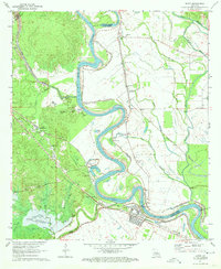
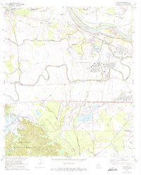
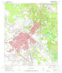 1972 Alexandria1974 Print · USGSAlexandria and Pineville sit at a major rail and river crossroads in the early seventies, just as the urban landscape was maturing. Local historians can trace the footprints of Camp Beauregard, the VA Hospital, and family-named landmarks like Pierson Lake and Lee Heights.4 unique versions available
 - 1972 Map of Green Gables, 1974 Print
 1972 Green Gables1974 Print · USGSRapides and Grant Parishes are captured in the early seventies, a landscape defined by the military grounds of Camp Beauregard and the Kisatchie National Forest. Researchers can trace the rural community of Green Gables, the airfield at ESLER FIELD, and local landmarks like Pheasant Grove Ch and Lofton Cem.2 unique versions available
 - 1972 Map of Cheneyville, 1974 Print
 1972 Cheneyville1974 Print · USGSCheneyville and the surrounding Rapides Parish lowlands are captured here in the early seventies, showcasing a landscape defined by meandering bayous and rail heritage. Genealogists and local historians can locate Stafford Cem, St Samuel Ch, and the intersection of the Texas and Pacific and Southern Pacific lines.3 unique versions available
 - 1972 Map of Powell Point, 1974 Print
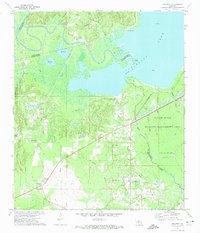
 1972 Powell Point1974 Print · USGSLouisiana's river-and-bayou country is captured here in the early seventies, spanning four parish boundaries. Genealogists and historians can trace local landmarks like Deville Cem or explore the mid-century energy footprint of the Saline Lake Oil Field and West Saline Lake Oil Field.3 unique versions available
 - 1972 Map of Libuse, 1974 Print
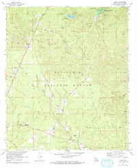
 1972 Libuse1974 Print · USGSNortheast of the Red River in the 1970s, this area preserves the unique cultural footprint of Central Louisiana's Czech settlements. Genealogists and historians can locate family sites at the Libuse Czech Cem, Kolin, and the Ruby-Wise Jr High Sch.2 unique versions available
 - 1972 Map of Latanier, 1974 Print
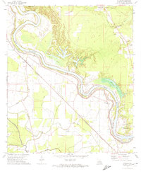 1972 Latanier1974 Print · USGSRapides Parish in the early 1970s shows a landscape deeply tied to the meanders of the Red River. Researchers can trace old rural communities like Latanier and Poland, alongside landmarks like Riverview Church and the Ruby Lookout Tower.2 unique versions available
 - 1978 Map of Sieper, 1979 Print
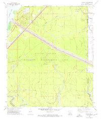
 1978 Sieper1979 Print · USGSRapides and Vernon Parishes come alive in this late-seventies survey of the Louisiana piney woods. Researchers can trace the Calcasieu River and locate family landmarks like Pisgah Ch Cem, Hardshell Cem, and the community of Sieper.
End of results
Showing maps 1-21 of 21
Top cities of Rapides Parish
- Alexandria historical maps
- Pineville historical maps
- Ball historical maps
- Glenmora historical maps
- Lecompte historical maps
- Boyce historical maps
See more
Frequently asked questions
- What are the different types of historical maps available for Rapides Parish?
- What is the oldest map of Rapides Parish?
- Where can I purchase historical maps of Rapides Parish for my home or office?
- Where can I download high-res historical maps of Rapides Parish?
- Are there historical topographic maps available for Rapides Parish?
- Is there historical aerial imagery available for Rapides Parish?
- Where are historical maps of Rapides Parish sourced from?