1990s Maps of Rapides Parish, Louisiana
Explore 8 historic maps of Rapides Parish from the 1990s. These maps offer a rare glimpse into what life looked like during the 1990s — showing old roads, neighborhoods, homes, and landmarks that have changed or disappeared over time.
Whether you're researching your family's past, planning a metal detecting trip, or studying how Rapides Parish's landscape evolved across the 1990s, these high-resolution maps are a powerful tool for exploring the history of this region.
- Focus on a specific era: All maps on this page are from the 1990s, giving you a focused view of this time period.
- See what’s changed: Compare century-old streets, trails, and buildings to today's modern landscape using overlays and satellite layers.
- Research with precision: Use these maps for genealogy, historical research, land use analysis, or educational projects.
- View, download, or print: Maps are fully viewable online in high resolution, and can be downloaded or printed for your own records.
Start exploring Rapides Parish's history through authentic maps from the 1990s. This is your window into the past.
Rapides Parish, LA maps
(8)- 1993 Map of Effie
 1993 Effie1993 Print · USGSAvoyelles and Rapides Parishes are shown in the early nineties as the Red River shapes the local landscape and culture. Genealogists and researchers can trace family landmarks like Pierce Cem, Hays Chapel, and the community of Fifth Ward along the river's southern banks.
 - 1994 Map of Buckeye, 1996 Print
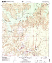
 1994 Buckeye1996 Print · USGSThe transition from the central Louisiana prairies to the bayous of the Red River valley is captured here in the mid-1990s. Genealogists can locate numerous rural burial sites like Hopewell Cem and Guillory Cem nestled among the wetlands of Big Island.
 - 1994 Map of Holloway, 1996 Print
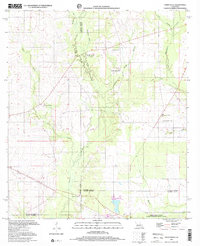
 1994 Holloway1996 Print · USGSLouisiana's wetlands meet industrial oil production in the mid-1990s as the northern shores of Catahoula Lake stretch across the Rapides Parish line. Researchers can trace rural landmarks like Holloway, local cemeteries, and the extent of the South Catahoula Oil Field.
 - 1997 Map of Steep Gully, 2001 Print
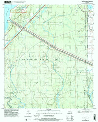
 1997 Steep Gully2001 Print · USGSThe rural pine woods and bayous of Central Louisiana come into focus in the late 1990s as several parish lines converge. Genealogists can trace family connections through sites like Tenmile Cem, Plainview Sch, and the uniquely named Occupy Ch No 1.
 - 1998 Map of Alexandria, 2001 Print
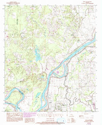
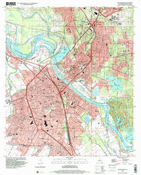 1998 Alexandria2001 Print · USGSAlexandria and Pineville sit at a vital crossing of the Red River during the late twentieth century. Genealogists and historians can trace neighborhood development through numerous local schools and landmarks like the Alexandria National Cem and Camp Beauregard.
 - 1998 Map of Cocodrie Lake, 2002 Print
 1998 Cocodrie Lake2002 Print · USGSThe central Louisiana wetlands come into focus in the late nineties as a landscape of bayous, landings, and industrial change. Genealogists and historians can locate remote sites like Dupissey Cem, the settlement of Clearwater, and the Old Railroad Grade.
 - 1998 Map of Buckeye NE, 2002 Print
 1998 Buckeye NE2002 Print · USGSThe LaSalle Parish wetlands near the turn of the millennium reveal a landscape of managed conservation and intensive oil production. Researchers can trace the industrial footprint of the West Elm Ridge Oil Field alongside the protected Dewey W Wills State Wildlife Management Area.
 - 1998 Map of Holloway, 2004 Print
 1998 Holloway2004 Print · USGSThe marshy parish borders of Central Louisiana were a landscape of industrial extraction and conservation at the close of the twentieth century. Researchers can trace the boundaries of the South Catahoula Oil Field, locate the Holloway settlement, and explore the wetlands of Catahoula Lake.
End of results
Showing maps 1-8 of 8
Top cities of Rapides Parish
- Alexandria historical maps
- Pineville historical maps
- Ball historical maps
- Glenmora historical maps
- Lecompte historical maps
- Boyce historical maps
See more
Frequently asked questions
- What are the different types of historical maps available for Rapides Parish?
- What is the oldest map of Rapides Parish?
- Where can I purchase historical maps of Rapides Parish for my home or office?
- Where can I download high-res historical maps of Rapides Parish?
- Are there historical topographic maps available for Rapides Parish?
- Is there historical aerial imagery available for Rapides Parish?
- Where are historical maps of Rapides Parish sourced from?