1950s Maps of St. Tammany Parish, Louisiana
Explore 26 historic maps of St. Tammany Parish from the 1950s. These maps offer a rare glimpse into what life looked like during the 1950s — showing old roads, neighborhoods, homes, and landmarks that have changed or disappeared over time.
Whether you're researching your family's past, planning a metal detecting trip, or studying how St. Tammany Parish's landscape evolved across the 1950s, these high-resolution maps are a powerful tool for exploring the history of this region.
- Focus on a specific era: All maps on this page are from the 1950s, giving you a focused view of this time period.
- See what’s changed: Compare century-old streets, trails, and buildings to today's modern landscape using overlays and satellite layers.
- Research with precision: Use these maps for genealogy, historical research, land use analysis, or educational projects.
- View, download, or print: Maps are fully viewable online in high resolution, and can be downloaded or printed for your own records.
Start exploring St. Tammany Parish's history through authentic maps from the 1950s. This is your window into the past.
St. Tammany Parish, LA maps
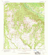
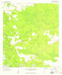
(26)- 1950 Map of Folsom
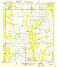 1950 Folsom1950 Print · USGSThe northern piney woods of St. Tammany Parish are captured here at mid-century, centered on the crossroads of Folsom. Local historians can trace family roots at Owens Cem and Pierre Cem or locate early schools like the Folsom Rosenwald Sch.
 - 1950 Map of Haaswood
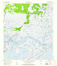
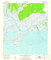
 1950 Haaswood1950 Print · USGSThe Pearl River bottomlands at the turn of the 1950s showcase a maze of islands and bayous along the Louisiana and Mississippi state line. Researchers can locate community anchors like Indian Village Sch, Hartsell Ch, and the riverside settlement of Logtown.
 - 1950 Map of Slidell, 1962 Print
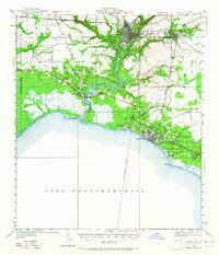
 1950 Slidell1962 Print · USGSThe Northshore of Lake Pontchartrain comes into focus at mid-century, showing the growing rail hubs and marshland settlements. Genealogists can trace family footprints at Forest Glen School, the Parker Cemetery, and rural outposts like Hickory or Florenville.2 unique versions available
 - 1950 Map of Covington, 1965 Print
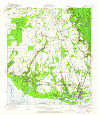
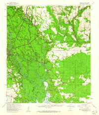
 1950 Covington1965 Print · USGSSt. Tammany Parish at mid-century reveals a landscape of river-port towns and growing lakeshore communities before the full expansion of the New Orleans suburbs. Genealogists can trace family sites near White Chapel, St James Ch, and the Rosenwald Sch or follow the historic Illinois Central rail line.
 - 1951 Map of South Point, 1952 Print
 1951 South Point1952 Print · USGSCoastal Orleans Parish in the early fifties shows a landscape defined by the expansive waters of Lake Pontchartrain. Researchers can trace the mid-century rail corridor of the Southern line and locate the small settlement at South Point near the Irish Bayou Lagoon.
 - 1951 Map of North Shore, 1952 Print
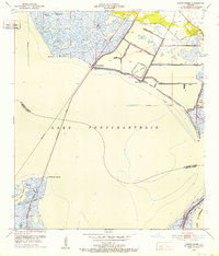 1951 North Shore1952 Print · USGSThe northern coast of Lake Pontchartrain in the early fifties reveals a landscape of marsh drainage canals and coastal settlements. Genealogists and researchers can trace the rail lines at North Shore, the early layout of Howze Beach, and the Fields Cem burial site.2 unique versions available
 - 1953 Map of Spanish Fort, 1954 Print
 1953 Spanish Fort1954 Print · USGSCoastal Jefferson and Orleans Parishes are shown in the early fifties during a period of significant drainage and airfield expansion. Researchers can trace the development of Metairie and West End or locate landmarks like Spanish Fort and the New Orleans Airport.
 - 1953 Map of Mobile, 1968 Print
 1953 Mobile1968 Print · USGSThe Gulf Coast comes alive in this mid-century survey, from the streets of Mobile to the marshes of New Orleans. Trace family roots in coastal towns like Pass Christian and Bayou La Batre or locate military landmarks including Keesler AFB.3 unique versions available
 - 1954 Map of Haaswood
 1954 Haaswood1954 Print · USGSSt. Tammany Parish at the mid-century is a maze of river bends and marshy bayous along the state line. Genealogists and historians can trace local landmarks like Indian Village Sch, Hartsell Ch, and the rail stop at Haaswood.
 - 1954 Map of English Lookout
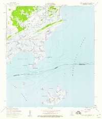
 1954 English Lookout1954 Print · USGSCoastal St. Tammany Parish comes alive in the mid-1950s, showing the intersection of heavy rail and the Mississippi delta. You can trace the Louisville and Nashville R R through English Lookout and explore bayous like Grassy Bayou and Kopman Bayou.
 - 1954 Map of Rigolets
 1954 Rigolets1954 Print · USGSCoastal Louisiana at the mid-century is defined by the critical deep-water passes between the great lakes and the Gulf. Genealogists and historians can trace the path of the Louisville and Nashville RR past Ft Pike and the remote outpost of Desert Id.
 - 1954 Map of Folsom, 1958 Print
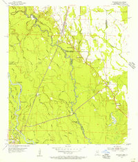
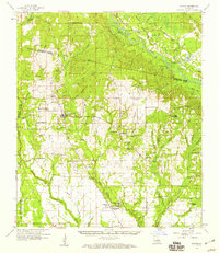
 1954 Folsom1958 Print · USGSLouisiana's northshore parishes come alive in the mid-1950s, revealing a landscape of winding river prongs and small rural settlements. Genealogists can trace family roots through numerous sites like Magee Cem, Fivemile Still Cem, and the Folsom Rosenwald Sch.
 - 1954 Map of Baton Rouge, 1974 Print
 1954 Baton Rouge1974 Print · USGSSoutheast Louisiana in the mid-fifties is captured here during a period of transition for its river and rail economies. Researchers can trace the path of the Mississippi River and find landmarks like the Bonnet Carre Spillway and Bayou Plaquemine.2 unique versions available
 - 1955 Map of Nicholson, 1956 Print
 1955 Nicholson1956 Print · USGSThe Pearl River bottomlands at the Mississippi-Louisiana border come to life in the mid-fifties, showing a landscape defined by braided bayous and timbered wetlands. Researchers can locate family landmarks like Turtleskin Cem and Oak Ridge Ch or trace the early footprint of Nicholson.5 unique versions available
 - 1956 Map of Baton Rouge
 1956 Baton Rouge1956 Print · USGSSouth Louisiana at the height of the mid-century oil boom shows a landscape of river oxbows and rising industry. Researchers can trace family roots through river towns like Scotlandville or locate early industrial sites and Oil wells near Lake Maurepas.
 - 1956 Map of Grand Island Pass, 1960 Print
 1956 Grand Island Pass1960 Print · USGSCoastal Hancock County and the Mississippi Sound marshes are captured here in the mid-fifties, showing the transition from historic land claims to small shore settlements. Genealogists can locate family landmarks like St Anns Ch, the Bayou Caddy Cem, and the old Nashville and Louisville Road.4 unique versions available
 - 1956 Map of Rigolets, 1960 Print
 1956 Rigolets1960 Print · USGSCoastal Louisiana at the height of the mid-century maritime era reveals a landscape of tidal passes and strategic rail corridors. Trace the path of the Louisville and Nashville railroad past Fort Pike State Monument and the historic Townes Mill Pond.2 unique versions available
 - 1956 Map of English Lookout, 1960 Print
 1956 English Lookout1960 Print · USGSCoastal marshes and river bayous dominate this mid-century survey of the Mississippi-Louisiana border. Genealogists and historians can trace early land boundaries like the Nancy Collins Claim and transport history along the Old Railroad Grade and the Louisville and Nashville line.2 unique versions available
 - 1956 Map of Rigolets, 1966 Print
 1956 Rigolets1966 Print · USGSThe coastal marshes of the Louisiana-Mississippi border come alive in this mid-century survey of the Pearl River delta. Researchers can trace the path of the L & N RR through Pearlington and locate the historic defenses at Fort Pike.
 - 1957 Map of Mobile
 1957 Mobile1957 Print · USGSThe Gulf Coast in the mid-1950s reveals a bustling corridor of rail-and-river commerce connecting Alabama to Louisiana. Genealogists and historians can trace old settlements and military hubs from Keesler Afb to the coastal reaches of Ship Island and Bogalusa.3 unique versions available
 - 1958 Map of Logtown, 1959 Print
 1958 Logtown1959 Print · USGSCoastal Hancock County in the late fifties was a network of river-bound settlements and lowland marshes. Genealogists and historians can trace the foundations of Logtown and Pearlington through landmarks like The Point Cem and Mt Zion Ch.4 unique versions available
 - 1958 Map of Folsom, 1959 Print
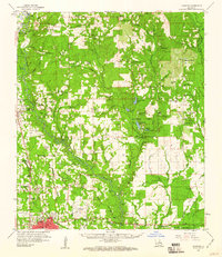
 1958 Folsom1959 Print · USGSSt. Tammany and Washington Parishes are shown in the late fifties as a landscape of rural churches, schools, and family cemeteries. Genealogists and historians can trace family locations through sites like Fivemile Still Cem, the Folsom Rosenwald Sch, and the St Gertrude Convent.2 unique versions available
 - 1958 Map of Picayune, 1959 Print
 1958 Picayune1959 Print · USGSPicayune and the surrounding Pearl River County countryside are captured here in the late fifties as the timber and rail economy shaped the landscape. Genealogists and local historians can trace rural family sites like Thigpen Cem, the Lee Sch, and the small settlement at Ozona.2 unique versions available
 - 1959 Map of Hammond, 1960 Print
 1959 Hammond1960 Print · USGSTangipahoa Parish at the close of the 1950s showcases a landscape where the river-and-rail economy met the growth of Southeastern La College. Genealogists can trace family names through dozens of rural sites like Briar Patch Cem, Union Training Sch, and Cooper Chapel.2 unique versions available
 - 1959 Map of Nicholson, 1960 Print
 1959 Nicholson1960 Print · USGSThe Pearl River valley in the late fifties was a network of riverfront settlements and deep-swamp bayous at the Mississippi-Louisiana border. Researchers can trace the river's winding course through Gainesville, locate family sites at Haaswood Cem, or find rural landmarks like Flattop Sch.3 unique versions available
Showing maps 1-25 of 26
Top cities of St. Tammany Parish
- Slidell historical maps
- Mandeville historical maps
- Covington historical maps
- Abita Springs historical maps
- Madisonville historical maps
- Folsom historical maps
See more
Frequently asked questions
- What are the different types of historical maps available for St. Tammany Parish?
- What is the oldest map of St. Tammany Parish?
- Where can I purchase historical maps of St. Tammany Parish for my home or office?
- Where can I download high-res historical maps of St. Tammany Parish?
- Are there historical topographic maps available for St. Tammany Parish?
- Is there historical aerial imagery available for St. Tammany Parish?
- Where are historical maps of St. Tammany Parish sourced from?