1900s (20th Century) Maps of St. Tammany Parish, Louisiana
Explore 114 historic maps of St. Tammany Parish from the 1900s (20th Century). These maps offer a rare glimpse into what life looked like during the 1900s — showing old roads, neighborhoods, homes, and landmarks that have changed or disappeared over time.
Whether you're researching your family's past, planning a metal detecting trip, or studying how St. Tammany Parish's landscape evolved across the 1900s, these high-resolution maps are a powerful tool for exploring the history of this region.
- Focus on a specific era: All maps on this page are from the 1900s, giving you a focused view of this time period.
- See what’s changed: Compare century-old streets, trails, and buildings to today's modern landscape using overlays and satellite layers.
- Research with precision: Use these maps for genealogy, historical research, land use analysis, or educational projects.
- View, download, or print: Maps are fully viewable online in high resolution, and can be downloaded or printed for your own records.
Start exploring St. Tammany Parish's history through authentic maps from the 1900s. This is your window into the past.
St. Tammany Parish, LA maps
(114)- 1914 Map of Nicholson, 1957 Print
 1914 Nicholson1957 Print · USGSThe Pearl River swamp along the Louisiana-Mississippi border was a landscape of timber and tides during the early twentieth century. Genealogists can locate family-named settlements like Logtown and Gainsville or trace the early paths of the 3 Notch Road.2 unique versions available
 - 1921 Map of Nicholson
 1921 Nicholson1921 Print · USGSThe borderlands of Mississippi and Louisiana are captured here in the early 1920s, showing a river-driven landscape of timber and rail. Researchers can trace the riverfront communities of Gainsville and Logtown alongside the historic 3 Notch Road.
 - 1935 Map of Slidell
 1935 Slidell1935 Print · USGSCoastal Louisiana in the mid-thirties reveals a landscape of growing rail towns and bayou settlements tied to the Gulf and the Pearl River systems. Genealogists and local historians can trace family roots through the Welch Cem, the Peace Grove Sch, and vanished hubs like McClure City.3 unique versions available
 - 1935 Map of English Lookout
 1935 English Lookout1935 Print · USGSThe coastal marshlands at the Louisiana-Mississippi line are captured in the mid-1930s as the rail line bridges the delta. Trace the historic route of the Louisville and Nashville railroad through English Lookout and across the waters of Little Lake.
 - 1935 Map of Covington
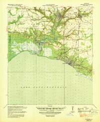
 1935 Covington1935 Print · USGSSt. Tammany Parish thrived as a river and rail hub during the mid-1930s, anchored by the bustling towns along Lake Pontchartrain. Researchers can trace the path of the Illinois Central RR and locate local landmarks like the Rosenwald Sch or the Chefuncte LH.3 unique versions available
 - 1935 Map of Grand Island Pass
 1935 Grand Island Pass1935 Print · USGSThe maritime boundary between Mississippi and Louisiana is captured here in the mid-1930s, centering on the tidal marshes of Grand Island. Researchers can trace the winding paths of Gauthier Bayou and West Bayou through the coastal wetlands.2 unique versions available
 - 1936 Map of North Shore
 1936 North Shore1936 Print · USGSCoastal St. Tammany Parish in the mid-thirties is defined by its sprawling wetlands and the early infrastructure crossing the water. Researchers can trace the original rail lines of the Southern and Southern Pontchartrain as they connect landings like North Shore and Howze Beach.
 - 1936 Map of South Point
 1936 South Point1936 Print · USGSCoastal Orleans Parish in the mid-1930s is a landscape of expansive water and critical rail links along the shore. Researchers can trace the path of the Southern railroad as it reaches South Point and locate marshland features like Irish Lagoon.
 - 1936 Map of Chef Menteur, 1938 Print
 1936 Chef Menteur1938 Print · USGSCoastal New Orleans and the Rigolets area are shown in the mid-1930s as drainage projects and rail lines reshaped the marshlands. Researchers can trace early settlements at Little Woods and Micheaud, or locate sites like Fort Macomb and the Dead Cypress Swamp.2 unique versions available
 - 1936 Map of Spanish Fort, 1938 Print
 1936 Spanish Fort1938 Print · USGSThe New Orleans lakefront in the mid-1930s reveals a landscape of leisure and engineering as the city expanded toward the water. Trace the footprints of Pontchartrain Beach Amusement Park, the historic docks at Milneburg, and the path of the Old Spanish Trail.
 - 1936 Map of Rigolets, 1949 Print
 1936 Rigolets1949 Print · USGSCoastal Louisiana and Mississippi meet in the mid-1930s where the Pearl River delta fragments into a maze of islands and bayous. Researchers can trace the early path of Highway No 90, the defenses at Fort Pike, and settlements like Pearlington or Baldwin Lodge.
 - 1939 Map of Slidell
 1939 Slidell1939 Print · USGSSt. Tammany Parish in the late thirties is a landscape of thriving bayou communities and expanding rail corridors near the lakefront. Genealogists can trace family landmarks like Crawford Cem, McClane City, and the Edgar Doucette Sch.
 - 1939 Map of Zona
 1939 Zona1939 Print · USGSThe borderlands of Washington and St. Tammany Parishes are captured here in the late 1930s as a landscape of river-bottom farms and small settlements. Researchers can locate family landmarks like Magee Cem, Union Grove Sch, and the Airway Beacon near Enon.
 - 1939 Map of Covington
 1939 Covington1939 Print · USGSSt. Tammany Parish thrived as a river and rail corridor before mid-century, where the Bogue Falaya met the northern shore of Lake Pontchartrain. Genealogists and historians can trace family roots through the Rosenwald Sch, Little Zion Ch & Cem, and the old rail routes of the Illinois Central.
 - 1941 Map of Honey Island
 1941 Honey Island1941 Print · USGSThe lower Pearl River basin at the start of the 1940s reveals a dense network of swamp bayous and rail sidings. Genealogists and historians can trace the paths of Highway No 11 and the Southern railroad through Benton and past Honey Island.
 - 1942 Map of Onville
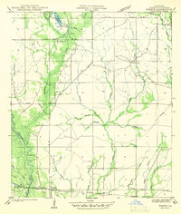
 1942 Onville1942 Print · USGSThe rural borderlands of St. Tammany and Tangipahoa Parish are meticulously detailed in this early 1940s survey. Genealogists and local historians can locate family landmarks like Fendlason Cem, the Onville Sch, and the Live Oak Ch.
 - 1942 Map of Waldheim
 1942 Waldheim1942 Print · USGSThe piney woods of St. Tammany Parish appear in the late thirties as a landscape of small settlements and river-carved terrain. Researchers can locate family landmarks like the Fitzgerald Cem, Waldheim Sch, and the St Gertrudes Convent.
 - 1942 Map of Husser
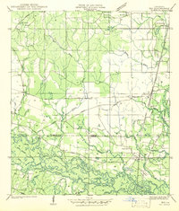
 1942 Husser1942 Print · USGSIn the early 1940s, the rural reaches of Tangipahoa Parish were a patchwork of small schools, family cemeteries, and winding creeks. Genealogists and local historians can trace community roots through sites like Stevens Cem, St Dominic Sch, and Sudville Ch.
 - 1942 Map of Robert
 1942 Robert1942 Print · USGSTangipahoa Parish in the early 1940s was a landscape of river-fed lowlands and timber-rich estates. Researchers can locate family landmarks like Reid Cem, trace the Illinois Central tracks, or find local centers like Uneedus Sch and Zemurray Lodge.
 - 1942 Map of Talisheek
 1942 Talisheek1942 Print · USGSSt. Tammany Parish during the early war years shows a rural landscape of logging railroads and creek-fed bottomlands. Genealogists can locate family landmarks like Slavinghouse Cem, Old CCC Camp, and Grimmett Siding along the rail line.
 - 1942 Map of Rio
 1942 Rio1942 Print · USGSThe borderlands of Washington and St. Tammany Parishes are captured here in the early 1940s as the Bogue Chitto River winds through the southern woods. Researchers can locate many family-named landmarks including the Old Magee Cem, Rosenwald Sch, and the rail stop at Rio.
 - 1942 Map of Walkiah Bluff
 1942 Walkiah Bluff1942 Print · USGSSt. Tammany Parish, Louisiana, during the early 1940s reveals a dense network of river sloughs and active timber lands. Genealogists and historians can trace family burial sites at Thomas Cem and Keller Cem or locate the defunct Logging Railroad Grade.
 - 1942 Map of Pools Bluff
 1942 Pools Bluff1942 Print · USGSThe Pearl River bottomlands at the start of the 1940s reveal a landscape of dense bayous and isolated river settlements. Genealogists can locate family burial grounds like Sheridan Cem and Morris Cem, or trace early transit routes such as the Float Road.
 - 1946 Map of Rigolets
 1946 Rigolets1946 Print · USGSCoastal St. Tammany Parish at the end of the Second World War was a labyrinth of tidal passes and marsh ridges. Genealogists and historians can trace the strategic layout of Ft Pike, the small settlement at Rigolets, and the remote W Rigolets L H light station.
 - 1949 Map of Grand Island Pass
 1949 Grand Island Pass1949 Print · USGSThe coastal boundary of Louisiana and Mississippi is captured here in the late 1940s, just before significant coastal changes reshaped the marsh. Researchers can trace the mid-century shoreline of Grand Island and locate the Lake Borgne L. H. at the edge of the Mississippi Sound.
Showing maps 1-25 of 114
Top cities of St. Tammany Parish
- Slidell historical maps
- Mandeville historical maps
- Covington historical maps
- Abita Springs historical maps
- Madisonville historical maps
- Folsom historical maps
See more
Frequently asked questions
- What are the different types of historical maps available for St. Tammany Parish?
- What is the oldest map of St. Tammany Parish?
- Where can I purchase historical maps of St. Tammany Parish for my home or office?
- Where can I download high-res historical maps of St. Tammany Parish?
- Are there historical topographic maps available for St. Tammany Parish?
- Is there historical aerial imagery available for St. Tammany Parish?
- Where are historical maps of St. Tammany Parish sourced from?