Old Maps of St. Tammany Parish, Louisiana for Academic Research
Study the evolution of St. Tammany Parish with 264 high-resolution historic maps. Whether you're teaching, researching, or modeling changes in land use, these maps provide essential visual documentation of urban, environmental, and geographic change.
- Analyze long-term change: Track patterns in development, transportation, and natural features.
- Ideal for environmental or urban studies: Support academic projects with primary historical map data.
- Use in the classroom or lab: Educators and researchers rely on these maps to bring historical context to life.
These maps are a powerful tool for teaching, research, and visualizing how St. Tammany Parish has changed over the decades.
St. Tammany Parish, LA maps
(264)- 1891 Map of Spanish Fort
 1891 Spanish Fort1891 Print · USGSThe New Orleans lakefront in the early 1890s was a landscape of emerging rail hubs and shoreline outposts. Trace the early footprints of Milneburg, Spanish Fort, and the lighthouse stations along Lake Pontchartrain during this pivotal era of coastal growth.4 unique versions available
 - 1892 Map of Chef Menteur
 1892 Chef Menteur1892 Print · USGSThe marshlands of eastern Orleans Parish appear here in the 1890s as a strategic coastal corridor of railroads and water passages. Researchers can trace the early rail stops at Micheaud and Lee, or locate the historic site of Ft Macomb near the Chef Menteur crossing.5 unique versions available
 - 1893 Map of Rigolets
 1893 Rigolets1893 Print · USGSCoastal Louisiana and Mississippi meet at the turn of the century along a labyrinth of marshlands and railroad trestles. Researchers can trace the early path of the Louisville and Nashville Railroad past Ft. Pike and through the Little Lake region.5 unique versions available
 - 1893 Map of Toulme
 1893 Toulme1893 Print · USGSThe coastal marshlands of Hancock County are captured in the late 1890s, where the rail line meets the sound. Genealogists and maritime historians can trace the lonely locations of the St. Joseph Island Light, the settlement at Toulme, and the intricate reaches of Heron Bay.4 unique versions available
 - 1914 Map of Nicholson, 1957 Print
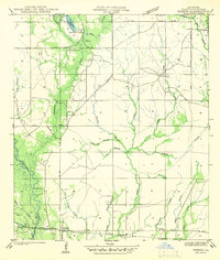
 1914 Nicholson1957 Print · USGSThe Pearl River swamp along the Louisiana-Mississippi border was a landscape of timber and tides during the early twentieth century. Genealogists can locate family-named settlements like Logtown and Gainsville or trace the early paths of the 3 Notch Road.2 unique versions available
 - 1921 Map of Nicholson
 1921 Nicholson1921 Print · USGSThe borderlands of Mississippi and Louisiana are captured here in the early 1920s, showing a river-driven landscape of timber and rail. Researchers can trace the riverfront communities of Gainsville and Logtown alongside the historic 3 Notch Road.
 - 1935 Map of Slidell
 1935 Slidell1935 Print · USGSCoastal Louisiana in the mid-thirties reveals a landscape of growing rail towns and bayou settlements tied to the Gulf and the Pearl River systems. Genealogists and local historians can trace family roots through the Welch Cem, the Peace Grove Sch, and vanished hubs like McClure City.3 unique versions available
 - 1935 Map of English Lookout
 1935 English Lookout1935 Print · USGSThe coastal marshlands at the Louisiana-Mississippi line are captured in the mid-1930s as the rail line bridges the delta. Trace the historic route of the Louisville and Nashville railroad through English Lookout and across the waters of Little Lake.
 - 1935 Map of Covington
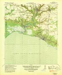
 1935 Covington1935 Print · USGSSt. Tammany Parish thrived as a river and rail hub during the mid-1930s, anchored by the bustling towns along Lake Pontchartrain. Researchers can trace the path of the Illinois Central RR and locate local landmarks like the Rosenwald Sch or the Chefuncte LH.3 unique versions available
 - 1935 Map of Grand Island Pass
 1935 Grand Island Pass1935 Print · USGSThe maritime boundary between Mississippi and Louisiana is captured here in the mid-1930s, centering on the tidal marshes of Grand Island. Researchers can trace the winding paths of Gauthier Bayou and West Bayou through the coastal wetlands.2 unique versions available
 - 1936 Map of North Shore
 1936 North Shore1936 Print · USGSCoastal St. Tammany Parish in the mid-thirties is defined by its sprawling wetlands and the early infrastructure crossing the water. Researchers can trace the original rail lines of the Southern and Southern Pontchartrain as they connect landings like North Shore and Howze Beach.
 - 1936 Map of South Point
 1936 South Point1936 Print · USGSCoastal Orleans Parish in the mid-1930s is a landscape of expansive water and critical rail links along the shore. Researchers can trace the path of the Southern railroad as it reaches South Point and locate marshland features like Irish Lagoon.
 - 1936 Map of Chef Menteur, 1938 Print
 1936 Chef Menteur1938 Print · USGSCoastal New Orleans and the Rigolets area are shown in the mid-1930s as drainage projects and rail lines reshaped the marshlands. Researchers can trace early settlements at Little Woods and Micheaud, or locate sites like Fort Macomb and the Dead Cypress Swamp.2 unique versions available
 - 1936 Map of Spanish Fort, 1938 Print
 1936 Spanish Fort1938 Print · USGSThe New Orleans lakefront in the mid-1930s reveals a landscape of leisure and engineering as the city expanded toward the water. Trace the footprints of Pontchartrain Beach Amusement Park, the historic docks at Milneburg, and the path of the Old Spanish Trail.
 - 1936 Map of Rigolets, 1949 Print
 1936 Rigolets1949 Print · USGSCoastal Louisiana and Mississippi meet in the mid-1930s where the Pearl River delta fragments into a maze of islands and bayous. Researchers can trace the early path of Highway No 90, the defenses at Fort Pike, and settlements like Pearlington or Baldwin Lodge.
 - 1939 Map of Slidell
 1939 Slidell1939 Print · USGSSt. Tammany Parish in the late thirties is a landscape of thriving bayou communities and expanding rail corridors near the lakefront. Genealogists can trace family landmarks like Crawford Cem, McClane City, and the Edgar Doucette Sch.
 - 1939 Map of Zona
 1939 Zona1939 Print · USGSThe borderlands of Washington and St. Tammany Parishes are captured here in the late 1930s as a landscape of river-bottom farms and small settlements. Researchers can locate family landmarks like Magee Cem, Union Grove Sch, and the Airway Beacon near Enon.
 - 1939 Map of Covington
 1939 Covington1939 Print · USGSSt. Tammany Parish thrived as a river and rail corridor before mid-century, where the Bogue Falaya met the northern shore of Lake Pontchartrain. Genealogists and historians can trace family roots through the Rosenwald Sch, Little Zion Ch & Cem, and the old rail routes of the Illinois Central.
 - 1941 Map of Honey Island
 1941 Honey Island1941 Print · USGSThe lower Pearl River basin at the start of the 1940s reveals a dense network of swamp bayous and rail sidings. Genealogists and historians can trace the paths of Highway No 11 and the Southern railroad through Benton and past Honey Island.
 - 1942 Map of Onville
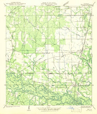
 1942 Onville1942 Print · USGSThe rural borderlands of St. Tammany and Tangipahoa Parish are meticulously detailed in this early 1940s survey. Genealogists and local historians can locate family landmarks like Fendlason Cem, the Onville Sch, and the Live Oak Ch.
 - 1942 Map of Waldheim
 1942 Waldheim1942 Print · USGSThe piney woods of St. Tammany Parish appear in the late thirties as a landscape of small settlements and river-carved terrain. Researchers can locate family landmarks like the Fitzgerald Cem, Waldheim Sch, and the St Gertrudes Convent.
 - 1942 Map of Husser
 1942 Husser1942 Print · USGSIn the early 1940s, the rural reaches of Tangipahoa Parish were a patchwork of small schools, family cemeteries, and winding creeks. Genealogists and local historians can trace community roots through sites like Stevens Cem, St Dominic Sch, and Sudville Ch.
 - 1942 Map of Robert
 1942 Robert1942 Print · USGSTangipahoa Parish in the early 1940s was a landscape of river-fed lowlands and timber-rich estates. Researchers can locate family landmarks like Reid Cem, trace the Illinois Central tracks, or find local centers like Uneedus Sch and Zemurray Lodge.
 - 1942 Map of Talisheek
 1942 Talisheek1942 Print · USGSSt. Tammany Parish during the early war years shows a rural landscape of logging railroads and creek-fed bottomlands. Genealogists can locate family landmarks like Slavinghouse Cem, Old CCC Camp, and Grimmett Siding along the rail line.
 - 1942 Map of Rio
 1942 Rio1942 Print · USGSThe borderlands of Washington and St. Tammany Parishes are captured here in the early 1940s as the Bogue Chitto River winds through the southern woods. Researchers can locate many family-named landmarks including the Old Magee Cem, Rosenwald Sch, and the rail stop at Rio.
Showing maps 1-25 of 264
Top cities of St. Tammany Parish
- Slidell historical maps
- Mandeville historical maps
- Covington historical maps
- Abita Springs historical maps
- Madisonville historical maps
- Folsom historical maps
See more
Frequently asked questions
- What are the different types of historical maps available for St. Tammany Parish?
- What is the oldest map of St. Tammany Parish?
- Where can I purchase historical maps of St. Tammany Parish for my home or office?
- Where can I download high-res historical maps of St. Tammany Parish?
- Are there historical topographic maps available for St. Tammany Parish?
- Is there historical aerial imagery available for St. Tammany Parish?
- Where are historical maps of St. Tammany Parish sourced from?