1970s Maps of St. Tammany Parish, Louisiana
Explore 11 historic maps of St. Tammany Parish from the 1970s. These maps offer a rare glimpse into what life looked like during the 1970s — showing old roads, neighborhoods, homes, and landmarks that have changed or disappeared over time.
Whether you're researching your family's past, planning a metal detecting trip, or studying how St. Tammany Parish's landscape evolved across the 1970s, these high-resolution maps are a powerful tool for exploring the history of this region.
- Focus on a specific era: All maps on this page are from the 1970s, giving you a focused view of this time period.
- See what’s changed: Compare century-old streets, trails, and buildings to today's modern landscape using overlays and satellite layers.
- Research with precision: Use these maps for genealogy, historical research, land use analysis, or educational projects.
- View, download, or print: Maps are fully viewable online in high resolution, and can be downloaded or printed for your own records.
Start exploring St. Tammany Parish's history through authentic maps from the 1970s. This is your window into the past.
St. Tammany Parish, LA maps
(11)- 1970 Map of St. Tammany, 1972 Print
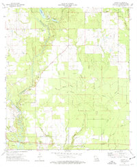
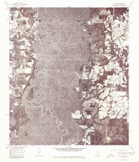
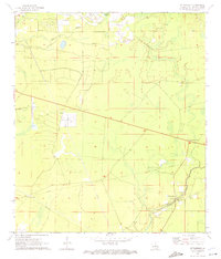 1970 St. Tammany1972 Print · USGSSt. Tammany Parish at the end of the sixties shows a landscape of creek-fed bottomlands and emerging utility infrastructure. Genealogists and local historians can locate Crow Cem and trace the paths of Lacombe Bayou and English Branch through the pine woods.3 unique versions available
 - 1971 Map of Hickory, 1972 Print
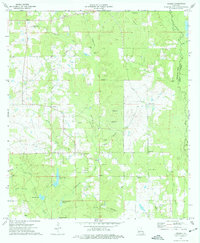
 1971 Hickory1972 Print · USGSSt. Tammany Parish in the early seventies remains a landscape of deep bayous and quiet settlements like Hickory and Florenville. Genealogists and local historians can trace family roots at Smith Cem and Welch Cem, or locate the Hickory Lookout Tower and Charter Oak Missionary Ch.4 unique versions available
 - 1971 Map of Lacombe, 1972 Print
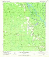
 1971 Lacombe1972 Print · USGSCoastal St. Tammany Parish is captured in the early seventies, showing the bayou communities as modern highways began to expand. Genealogists and historians can trace local landmarks like Lafere Cem, the Carmel Convent, and the Gulf Mobile and Ohio rail line.3 unique versions available
 - 1971 Map of Slidell, 1972 Print
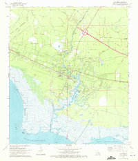
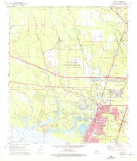 1971 Slidell1972 Print · USGSSlidell and the north shore of Lake Pontchartrain are captured here in the early seventies during a period of significant suburban and highway growth. Local researchers can trace family roots through numerous sites like Greenwood Cem or explore the grounds of Camp Villerre and Camp Salmen.5 unique versions available
 - 1974 Map of Robert, 1977 Print
 1974 Robert1977 Print · USGSTangipahoa Parish in the mid-seventies shows a landscape defined by river bottomlands and small rural outposts. Local historians can trace family roots through numerous burial sites and churches, from Wilson-Willie Cem to the First Missionary Ch near Robert.
 - 1974 Map of Hammond, 1977 Print
 1974 Hammond1977 Print · USGSTangipahoa Parish in the mid-1970s shows a landscape of growing towns and deep-rooted rural communities. Trace family history at Wainwright Cem or Shady Grove Ch, and explore the rail corridor through Independence and Natalbany.
 - 1974 Map of Husser, 1977 Print
 1974 Husser1977 Print · USGSTangipahoa Parish in the mid-seventies shows a landscape of timber stands and quiet rural settlements. Genealogists can trace family landmarks like Wainwright Cem and Olliphant Cem, or locate the Loranger Lookout Tower and Baldwin Chapel.2 unique versions available
 - 1976 Map of Folsom NE, 1977 Print
 1976 Folsom NE1977 Print · USGSThe rural timberlands and river bottoms of Washington Parish are captured here in the mid-1970s just as land-use patterns were shifting. You can trace the small community of Enon and the dramatic meanders of the Bogue and Chitto river system.
 - 1976 Map of Sun NW, 1977 Print
 1976 Sun NW1977 Print · USGSWashington Parish in the mid-seventies is documented here through high-resolution aerial photography of the rural pine woods and bottomlands. Researchers can trace property lines and roads around SUN and RIO or follow the path of Lees Creek as it winds through the timber.
 - 1976 Map of Sun NE, 1977 Print
 1976 Sun NE1977 Print · USGSThe borderlands between Mississippi and Louisiana appear in sharp detail in the mid-1970s. Trace the winding course of the Pearl River and the rural roads near Henleyfield and Lees Creek.
 - 1976 Map of Folsom NW, 1977 Print
 1976 Folsom NW1977 Print · USGSThe rural landscape north of Folsom is captured in sharp detail by this mid-1970s orthophoto. Local researchers can trace old road alignments and the footprint of the Folsom settlement amidst a mosaic of timberland and early agricultural clearings.
End of results
Showing maps 1-11 of 11
Top cities of St. Tammany Parish
- Slidell historical maps
- Mandeville historical maps
- Covington historical maps
- Abita Springs historical maps
- Madisonville historical maps
- Folsom historical maps
See more
Frequently asked questions
- What are the different types of historical maps available for St. Tammany Parish?
- What is the oldest map of St. Tammany Parish?
- Where can I purchase historical maps of St. Tammany Parish for my home or office?
- Where can I download high-res historical maps of St. Tammany Parish?
- Are there historical topographic maps available for St. Tammany Parish?
- Is there historical aerial imagery available for St. Tammany Parish?
- Where are historical maps of St. Tammany Parish sourced from?