1960s Maps of St. Tammany Parish, Louisiana
Explore 19 historic maps of St. Tammany Parish from the 1960s. These maps offer a rare glimpse into what life looked like during the 1960s — showing old roads, neighborhoods, homes, and landmarks that have changed or disappeared over time.
Whether you're researching your family's past, planning a metal detecting trip, or studying how St. Tammany Parish's landscape evolved across the 1960s, these high-resolution maps are a powerful tool for exploring the history of this region.
- Focus on a specific era: All maps on this page are from the 1960s, giving you a focused view of this time period.
- See what’s changed: Compare century-old streets, trails, and buildings to today's modern landscape using overlays and satellite layers.
- Research with precision: Use these maps for genealogy, historical research, land use analysis, or educational projects.
- View, download, or print: Maps are fully viewable online in high resolution, and can be downloaded or printed for your own records.
Start exploring St. Tammany Parish's history through authentic maps from the 1960s. This is your window into the past.
St. Tammany Parish, LA maps
(19)- 1960 Map of Mobile
 1960 Mobile1960 Print · USGSThe Gulf Coast at the dawn of the sixties shows a landscape of busy ports, military airbases, and barrier islands. Trace the rail lines of the Louisville & Nashville through BILOXI and Pascagoula or find family history in towns like Bayou La Batre and Poplarville.
 - 1961 Map of Sun, 1963 Print
 1961 Sun1963 Print · USGSLife along the Louisiana and Mississippi border centered on the river and the rail in the early sixties. Researchers can trace family history through dozens of rural landmarks like Byrds Chapel, Rio, and the Gulf Mobile and Ohio line.3 unique versions available
 - 1961 Map of Baton Rouge, 1966 Print
 1961 Baton Rouge1966 Print · USGSSoutheastern Louisiana in the early sixties remains a landscape of deep river bends and sprawling coastal lakes. Genealogists and historians can trace the rail-and-river economy through landmarks like Free-Nigger Point, Donaldsonville, and the Illinois Central Railroad.
 - 1962 Map of Baton Rouge
 1962 Baton Rouge1962 Print · USGSSouth Louisiana in the early sixties reveals a landscape of river-bend parishes and emerging interstate corridors. Genealogists and historians can trace family roots through historic river towns like Donaldsonville and Plaquemine, or follow the path of the Illinois Central Railroad through the swamp basins.
 - 1963 Map of Mobile
 1963 Mobile1963 Print · USGSThe Gulf Coast at the dawn of the sixties shows a thriving maritime and military corridor from Louisiana to Alabama. Genealogists and historians can trace rail lines like the Louisville & Nashville RR and find landmarks from Brookley AFB to Fort Morgan.
 - 1965 Map of Mobile
 1965 Mobile1965 Print · USGSThe Gulf Coast at mid-century reveals a landscape of expanding ports and vital military installations from Louisiana to Alabama. Genealogists and historians can trace the growth of Biloxi, Pascagoula, and Mobile, alongside the sprawling De Soto National Forest.
 - 1965 Map of Spanish Fort NE, 1966 Print
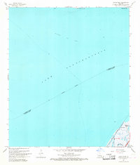
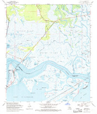
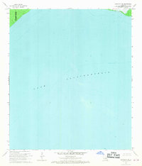
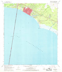
 1965 Spanish Fort NE1966 Print · USGSThe open waters of the Gulf Coast are captured in the mid-1960s at the intersection of three Louisiana parishes. Researchers can trace the path of the Lake Pontchartrain Causeway (Toll) and the Indefinite Boundary between St Tammany, Jefferson, and Orleans.2 unique versions available
 - 1967 Map of South Point, 1968 Print
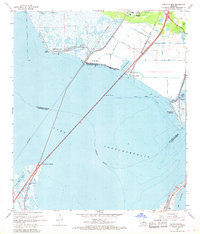
 1967 South Point1968 Print · USGSLake Pontchartrain and its coastal marshes are captured in the late sixties as industrial and transit networks expanded across the parish lines. Researchers can trace the early path of Interstate 10 near South Point and the underwater footprint of the Big Point Gas Field.3 unique versions available
 - 1967 Map of North Shore, 1968 Print
 1967 North Shore1968 Print · USGSThe northern reaches of Lake Pontchartrain appear here in the late sixties as the coastal communities near Slidell began to take shape. Genealogists and local historians can trace family sites like Fields Cem, North Shore Chapel, and the waterfront at North Shore Beach.5 unique versions available
 - 1967 Map of Spanish Fort, 1969 Print
 1967 Spanish Fort1969 Print · USGSThe Jefferson and Orleans Parish lakefronts are shown here in the late sixties as suburban expansion reached the shores of Lake Pontchartrain. Trace the development of neighborhoods like Bucktown and Indian Beach alongside the New Orleans Lakefront Airport.
 - 1968 Map of Rigolets, 1969 Print
 1968 Rigolets1969 Print · USGSThe Louisiana coast at the edge of the Rigolets shows a complex world of tidal passes and marsh islands in the late sixties. Trace the historic Fort Pike State Monument, the path of the Louisville and Nashville railroad, and landmarks like White Kitchen.4 unique versions available
 - 1968 Map of Covington SW, 1969 Print
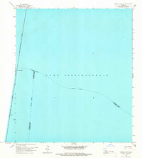
 1968 Covington SW1969 Print · USGSCoastal Louisiana in the late sixties is defined by the sweeping waters of Lake Pontchartrain along the parish lines. Researchers can trace the submerged topography and key maritime markers like the scattered Light aids used for navigation.2 unique versions available
 - 1968 Map of Covington, 1969 Print
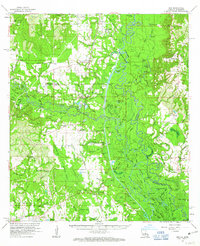
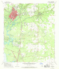 1968 Covington1969 Print · USGSNorth of Lake Pontchartrain in the late sixties, the landscape around COVINGTON and Mandeville shows a mix of riverfront settlement and woodland institutions. Genealogists can trace family landmarks like Wilson Cem, Chinchuba Cem, and the Rosenwald Sch at the height of the railroad era.4 unique versions available
 - 1968 Map of Madisonville, 1969 Print
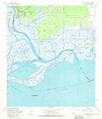
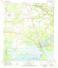 1968 Madisonville1969 Print · USGSThe Tchefuncta River basin in the late sixties shows a transition from traditional river life to modern parish growth. Genealogists and local researchers can locate numerous historical burial sites and landmarks like Rosenwald Sch Cem, Penns Chapel, and Goodbee.4 unique versions available
 - 1968 Map of Mandeville, 1969 Print
 1968 Mandeville1969 Print · USGSMandeville and the northern shore of Lake Pontchartrain appear here in the late sixties as the area grew around its traditional bayou boundaries. Researchers can trace the layout of local schools like Rosenwald Sch or locate the historic Southeast Louisiana Hospital and Lewisburg waterfront.5 unique versions available
 - 1968 Map of English Lookout, 1970 Print
 1968 English Lookout1970 Print · USGSThe coastal marshlands of the Louisiana-Mississippi border are captured in the late sixties as the Pearl River delta meets the Gulf. Genealogists and local historians can trace early property boundaries through the John B Doby Claim or follow the path of the Old Railroad Grade near English Lookout.3 unique versions available
 - 1969 Map of Rigolets, 1970 Print
 1969 Rigolets1970 Print · USGSThe Louisiana coast meets the Mississippi line in the late sixties, showing a landscape of tidal passes and railroad outposts. Researchers can trace the tracks of the Louisville and Nashville Railroad past English Lookout or locate the historic Port Pike State Monument.
 - 1969 Map of Chef Menteur, 1970 Print
 1969 Chef Menteur1970 Print · USGSEastern New Orleans and the Lake Pontchartrain shores are captured here during a decade of massive aerospace and industrial growth. Researchers can locate the sprawling Michoud Station, trace the Southern Railway through Slidell, and identify local sites like Abramson High Sch.
 - 1969 Map of Covington, 1971 Print
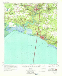 1969 Covington1971 Print · USGSSt. Tammany Parish's north shore of Lake Pontchartrain is shown in detail during the late sixties. Trace the development of Covington and Mandeville, or locate family sites like Daussin Cem and White Chapel.
End of results
Showing maps 1-19 of 19
Top cities of St. Tammany Parish
- Slidell historical maps
- Mandeville historical maps
- Covington historical maps
- Abita Springs historical maps
- Madisonville historical maps
- Folsom historical maps
See more
Frequently asked questions
- What are the different types of historical maps available for St. Tammany Parish?
- What is the oldest map of St. Tammany Parish?
- Where can I purchase historical maps of St. Tammany Parish for my home or office?
- Where can I download high-res historical maps of St. Tammany Parish?
- Are there historical topographic maps available for St. Tammany Parish?
- Is there historical aerial imagery available for St. Tammany Parish?
- Where are historical maps of St. Tammany Parish sourced from?