1890s Maps of Massachusetts
Explore 85 historic maps of Massachusetts from the 1890s. These maps offer a rare glimpse into what life looked like during the 1890s — showing old roads, neighborhoods, homes, and landmarks that have changed or disappeared over time.
Whether you're researching your family's past, planning a metal detecting trip, or studying how Massachusetts's landscape evolved across the 1890s, these high-resolution maps are a powerful tool for exploring the history of this region.
- Focus on a specific era: All maps on this page are from the 1890s, giving you a focused view of this time period.
- See what’s changed: Compare century-old streets, trails, and buildings to today's modern landscape using overlays and satellite layers.
- Research with precision: Use these maps for genealogy, historical research, land use analysis, or educational projects.
- View, download, or print: Maps are fully viewable online in high resolution, and can be downloaded or printed for your own records.
Start exploring Massachusetts's history through authentic maps from the 1890s. This is your window into the past.
Massachusetts maps
(85)- 1890 Map of Hawley
 1890 Hawley1890 Print · USGSFranklin County and the Vermont borderlands are shown here in the 1880s as the railroad era transformed the Deerfield Valley. Trace the path of the Fitchburg Railroad through the Hoosac Tunnel or find old roads in Hawley and Ashfield.
 - 1890 Map of Belchertown
 1890 Belchertown1890 Print · USGSThe Swift River valley is seen here in the late nineteenth century, long before the creation of the Quabbin Reservoir. Genealogists and local historians can trace the vanished streets of Enfield, Greenwich, and North Dana, or follow the old Boston & Albany R. R. line.
 - 1890 Map of Pittsfield
 1890 Pittsfield1890 Print · USGSThe Berkshires and New York borderlands are captured here in the late nineteenth century, showing a landscape defined by communal Shaker life and iron works. Researchers can trace the Lebanon Springs Railroad through Lebanon Springs or locate early industrial hubs like Richmond Furnace and Lower Barkerville.
 - 1890 Map of Narragansett Bay
 1890 Narragansett Bay1890 Print · USGSNarragansett Bay's western shore comes to life in the late nineteenth century, showing a landscape of rail-linked villages and coastal landmarks. Genealogists and historians can trace old homesteads and transit hubs from Wickford Junction to the State Farm and the Bristol Ferry.
 - 1890 Map of Brookfield
 1890 Brookfield1890 Print · USGSCentral Massachusetts and the Connecticut border lands are captured here in the late nineteenth century, showing a landscape defined by water power and rail. You can trace the Boston and Albany Railroad corridor and explore industrial pockets like Globe Village and the historic Leadmine site.
 - 1890 Map of Haverhill
 1890 Haverhill1890 Print · USGSSoutheastern New Hampshire and northern Massachusetts meet here in the 1890s along the industrial corridor of the Merrimac River. Local historians can trace the early rail network through Newton Junction, Salem Depot, and the dense street grids of Haverhill.
 - 1890 Map of Berlin
 1890 Berlin1890 Print · USGSThe New York and Massachusetts borderlands in the 1880s were a landscape of steep ridges and rail-connected valley towns. Genealogists and historians can trace the old corridors of the Lebanon Springs Railroad and locate vanished family landmarks near Berlin Center, Garfield, and East Poestenkill.
 - 1890 Map of Newburyport
 1890 Newburyport1890 Print · USGSThe coastal borderlands of Massachusetts and New Hampshire are shown here during a peak era of maritime and rail activity. Genealogists and local historians can trace family-named sites across Newbury Old Town, Byfield, and the bustling docks at Salisbury Point.
 - 1890 Map of Greenfield
 1890 Greenfield1890 Print · USGSFranklin County's industrial and rail corridors are captured in the late nineteenth century as the river valleys pulsed with water-powered manufacturing. Genealogists and historians can trace the foundations of Turners Falls, the layout of Lake Pleasant Camp Ground, and the rail connections at Conway Depot.
 - 1890 Map of Winchendon
 1890 Winchendon1890 Print · USGSThe Worcester County borderlands at the end of the 19th century reveal a complex landscape of mill villages and hilltop commons. Researchers can trace the early industrial footprint at Powers Mills, find the rail junction at Pequoig Station, and locate the ancestral centers of Royalston Center or Templeton Center.
 - 1891 Map of Northampton
 1891 Northampton1891 Print · USGSThe Pioneer Valley in the early nineties shows a landscape of river-driven industry and rising academic centers. Genealogists can trace family roots through old settlements like Bay State Village and Hockanum, or locate early campus sites at the Agricultural College.
 - 1891 Map of Greylock
 1891 Greylock1891 Print · USGSThe northern Berkshires are captured here in the late nineteenth century as rail lines and textile centers transformed the rugged valley floor. Genealogists and hikers can trace old homesteads and landmarks like Mt Greylock, the Hoosac Tunnel Line, and the vanished site of Arnoldsville.
 - 1891 Map of Sheffield
 1891 Sheffield1891 Print · USGSThe Housatonic Valley in the 1890s reveals a bustling corridor of rail-and-river commerce at the foot of the Berkshire mountains. Genealogists and historians can trace Victorian-era settlements from Great Barrington to Sheffield, locating old landmarks like Union Church and Chapinville Station.
 - 1892 Map of Boston Bay
 1892 Boston Bay1892 Print · USGSThe outer harbor and North Shore coastline are captured in the late Victorian era, before modern development reshaped the beaches and islands. Genealogists and maritime historians can trace the early rail lines to Revere Beach or locate historic defenses like Fort Warren and the iconic Boston Light.4 unique versions available
 - 1892 Map of Webster
 1892 Webster1892 Print · USGSWorcester County mill towns and rail junctions thrive in the 1890s as industrial centers along the French River. Genealogists and historians can trace the early footprints of Webster and Oxford, including vanished clusters like Merino Village and Chaseville.9 unique versions available
 - 1892 Map of Worcester
 1892 Worcester1892 Print · USGSWorcester and its northern hill towns are captured here in the late nineteenth century before the expansion of modern reservoirs. Researchers can trace the early rail networks through Sterling Junction or locate landmarks like the State Lunatic Hospital and Wire Village.10 unique versions available
 - 1892 Map of Narragansett Bay
 1892 Narragansett Bay1892 Print · USGSNarragansett Bay in the late nineteenth century reveals a coastline defined by maritime commerce and early rail connectivity. Genealogists can trace family roots in old village centers like Wickford, Apponaug, and Conimicut, or locate the State Prison near Natick.8 unique versions available
 - 1892 Map of Granby
 1892 Granby1892 Print · USGSThe Farmington River valley during the 1890s reveals a landscape of industrial hubs and steep ridges connected by a dense rail network. Researchers can trace historic landmarks like Satan's Kingdom and the routes of the Central New England and Western Railroad.8 unique versions available
 - 1893 Map of Abington
 1893 Abington1893 Print · USGSCoastal and inland Massachusetts thrive at the peak of the rail era, where the Old Colony Railroad links maritime harbors to inland factory towns. You can trace 19th-century village life through local landmarks like Weymouth Landing, Queen Ann Corners, and the Old Oaken Bucket Homestead.9 unique versions available
 - 1893 Map of Taunton
 1893 Taunton1893 Print · USGSTaunton flourished as a rail and manufacturing powerhouse during the late nineteenth century, situated at the nexus of the Old Colony Railroad system. Genealogists and historians can trace the early industrial sites like the Copper Works and Swansea Factory or find local landmarks such as Dighton Rock and the town Almshouse.7 unique versions available
 - 1893 Map of Nantucket
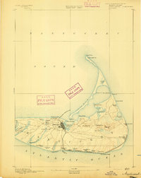 1893 Nantucket1893 Print · USGSNantucket in the late Victorian era is captured here as a maritime and burgeoning resort community. Genealogists and historians can trace the early Nantucket Railroad route or locate the Life Saving Station and Sankaty Head Lt. along the shore.2 unique versions available
 - 1893 Map of Northampton
 1893 Northampton1893 Print · USGSHampshire County in the late nineteenth century is a landscape of thriving mill towns and emerging college campuses. Trace the industrial operations at Factory Hollow or locate old crossings like the Smith Ferry and the Ferry at Hatfield.
 - 1893 Map of Springfield
 1893 Springfield1893 Print · USGSThe Pioneer Valley at the end of the nineteenth century centers on the bustling riverfronts of Springfield and Holyoke. Genealogists and historians can trace the rail-connected neighborhoods of Indian Orchard, the distinct Shakers settlement, and early industries along the Chicopee River.
 - 1893 Map of Franklin
 1893 Franklin1893 Print · USGSEastern Massachusetts at the close of the nineteenth century was a landscape of busy rail junctions and riverside mill towns. Researchers can trace the era's industrial footprint through sites like City Mills, Medfield Junc., and the isolated Burnt Swamp Corner.8 unique versions available
 - 1893 Map of Granville
 1893 Granville1893 Print · USGSHampden County and the northern Connecticut border are captured here in the late nineteenth century as the regional rail network matured. Genealogists and local historians can trace the early homesteads and hamlets of Blandford, Granville, and West Parish, while locating landmarks like Ore Hill and Salmon Falls.
Showing maps 1-25 of 85
Top cities of Massachusetts
- Boston historical maps
- Worcester historical maps
- Springfield historical maps
- Lowell historical maps
- Cambridge historical maps
- Brockton historical maps
See more
Top counties of Massachusetts
- Middlesex County historical maps
- Worcester County historical maps
- Suffolk County historical maps
- Essex County historical maps
- Norfolk County historical maps
- Bristol County historical maps
See more
Frequently asked questions
- What are the different types of historical maps available for Massachusetts?
- What is the oldest map of Massachusetts?
- Where can I purchase historical maps of Massachusetts for my home or office?
- Where can I download high-res historical maps of Massachusetts?
- Are there historical topographic maps available for Massachusetts?
- Is there historical aerial imagery available for Massachusetts?
- Where are historical maps of Massachusetts sourced from?