1990s Maps of Massachusetts
Explore 54 historic maps of Massachusetts from the 1990s. These maps offer a rare glimpse into what life looked like during the 1990s — showing old roads, neighborhoods, homes, and landmarks that have changed or disappeared over time.
Whether you're researching your family's past, planning a metal detecting trip, or studying how Massachusetts's landscape evolved across the 1990s, these high-resolution maps are a powerful tool for exploring the history of this region.
- Focus on a specific era: All maps on this page are from the 1990s, giving you a focused view of this time period.
- See what’s changed: Compare century-old streets, trails, and buildings to today's modern landscape using overlays and satellite layers.
- Research with precision: Use these maps for genealogy, historical research, land use analysis, or educational projects.
- View, download, or print: Maps are fully viewable online in high resolution, and can be downloaded or printed for your own records.
Start exploring Massachusetts's history through authentic maps from the 1990s. This is your window into the past.
Massachusetts maps
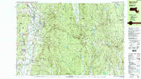
- 1990 Map of Ashfield
 1990 Ashfield1990 Print · USGSFranklin County's high country is captured here in the late twentieth century, showing a landscape of small hill towns and protected forests. Researchers can trace family sites at Pudding Hollow Cem or explore early settlements like Plainfield and South Hawley.2 unique versions available
 - 1990 Map of Northfield
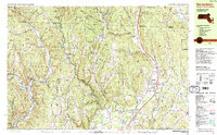
 1990 Northfield1990 Print · USGSThe tri-state border of Massachusetts, New Hampshire, and Vermont comes into focus in the 1990s as a landscape of river valleys and forested peaks. Researchers can trace the grounds of the Northfield Mt Hermon School or locate old burial sites like South Parish Cem and Center Cem.2 unique versions available
 - 1990 Map of Shutesbury
 1990 Shutesbury1990 Print · USGSFranklin County's landscape appears here in the final decade of the century, shaped by the massive waters of the Quabbin Reservoir. Genealogists and local historians can trace the remnants of displaced communities like Prescott Center and locate rural landmarks such as Fairview Cem and Locks Village.2 unique versions available
 - 1990 Map of Bernardston
 1990 Bernardston1990 Print · USGSFranklin County and the Vermont borderlands appear in the early nineties as a blend of Colonial frontier sites and industrial river hamlets. Researchers can locate historic fortifications like Fort Morrison (Site), rural schools like Leyden Sch, and family-named cemeteries such as Grove Cem.2 unique versions available
 - 1990 Map of Orange
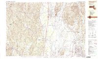
 1990 Orange1990 Print · USGSFranklin County's river valleys and state forests are meticulously detailed in the late twentieth century, showing the intersection of industry and nature. Genealogists can locate family burial sites at Dry Hill Cem and Wilbur Cem or trace the path of the Boston and Maine RR.2 unique versions available
 - 1990 Map of Rowe
 1990 Rowe1990 Print · USGSThe Deerfield River valley of northern Franklin County comes into focus in the 1980s, balancing industrial sites with large tracts of state forest. Genealogists and local historians can locate several family cemeteries, the Davis Mine, and the iconic Hoosac Tunnel.2 unique versions available
 - 1990 Map of Greenfield
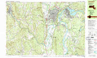 1990 Greenfield1990 Print · USGSUpper Massachusetts in the early nineties reveals a landscape of river-powered industry and prestigious academies. Genealogists and historians can trace family plots at Old Albany Cem or locate the sprawling campuses of Bement Sch and Greenfield Community College.3 unique versions available
 - 1990 Map of Goshen
 1990 Goshen1990 Print · USGSHampshire County in the early nineties remains a landscape of deep river valleys and high forest ridges. Genealogists and historians can locate rural landmarks like Goshen Cem, the Cummington Fairgrounds, and the Davenport Sch.
 - 1990 Map of Williamsburg
 1990 Williamsburg1990 Print · USGSIn the Pioneer Valley during the late twentieth century, the landscape transitioned from the rural hills of Williamsburg to the growing University of Massachusetts campus. Genealogists can trace family names at Whately Center Cem or Riverside Cem and find industrial landmarks like Factory Hollow.2 unique versions available
 - 1992 Map of Exeter, 1998 Print
 1992 Exeter1998 Print · USGSCoastal New Hampshire's transition from historic river towns to modern energy infrastructure is captured here in the early nineties. Genealogists and local historians can trace family-named crossroads like Eastman Corners, locate the campus of Phillips Exeter Academy, and identify old industrial sites like Coffins Mill.
 - 1993 Map of Chatham, 1994 Print
 1993 Chatham1994 Print · USGSBarnstable County's outer coast appears here in the early nineties, showcasing the protected lands of the Cape Cod National Seashore. Researchers can trace the shoreline from Nauset Beach Lighthouse down to the Monomoy National Wildlife Refuge.
 - 1994 Map of New Bedford
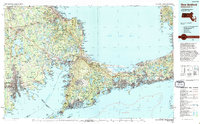 1994 New Bedford1994 Print · USGSSoutheastern Massachusetts and the Cape are shown in high detail during the mid-nineties, capturing the region's unique maritime geography and coastal infrastructure. Trace the transition from the industrial New Bedford Harbor to protected lands like Cape Cod National Seashore and Otis Air Force Base.
 - 1994 Map of Martha's Vineyard
 1994 Martha's Vineyard1994 Print · USGSThe islands of Martha's Vineyard and Nantucket are captured here in the mid-nineties, showing the established coastal villages and extensive conservation lands. Researchers can trace the boundaries of Manuel F Correllus State Forest or locate landmarks like the Lighthouse at Gay Head and Chappaquiddick Island.
 - 1994 Map of Siasconset
 1994 Siasconset1994 Print · USGSThe eastern edge of Nantucket at the close of the twentieth century shows a landscape of coastal bluffs and seaside villages. Trace family roots and local history near Siasconset or study landmarks like Sankaty Head Light and Sesachacha Pond.
 - 1994 Map of Hartford, 1995 Print
 1994 Hartford1995 Print · USGSGreater Hartford and the Connecticut River Valley are captured here in the mid-nineties, showing the dense intersection of industry and academia. Trace the urban footprint of the State Capitol and Trinity College or locate the sprawling grounds of the University of Connecticut.2 unique versions available
 - 1997 Map of East Lee, 1999 Print
 1997 East Lee1999 Print · USGSThe Berkshires in the late twentieth century remain a sanctuary of state forests and mountain trails. Genealogists and hikers can trace the Appalachian Trail past Washington Cem or locate the famed Jacob's Pillow School and Theatre.
 - 1997 Map of Great Barrington, 1999 Print
 1997 Great Barrington1999 Print · USGSThe Berkshires in the late 1990s show a refined balance of historic village life and extensive mountain conservation. Researchers can trace the Appalachian Trail over East Mtn or locate regional landmarks like Simons Rock Bard College and Lake Buel.
 - 1997 Map of Otis, 1999 Print
 1997 Otis1999 Print · USGSBerkshire County at the close of the twentieth century remains a landscape of deep forests and quiet hill towns. Researchers can trace the Appalachian Trail through Beartown State Forest or locate local landmarks like the Old Center Cem and Our Lady of the Hills Chapel.
 - 1997 Map of Goshen, 1999 Print
 1997 Goshen1999 Print · USGSThe hill towns of Hampshire County come into focus in the late 1990s, where protected state forests meet historic valley settlements along the Westfield River. Genealogists and historians can locate the Cummington Fairgrounds, Lithia Chapel, and several family-named burial sites like Dawes Cem.
 - 1997 Map of Assawompset Pond, 1999 Print
 1997 Assawompset Pond1999 Print · USGSThe Lakeville area at the close of the 20th century remains a landscape defined by its expansive pond system and deep-rooted family settlements. Researchers can trace ancestral locations across numerous cemeteries like Strowbridge Cem or locate community hubs like Sampsons Corner and Mullein Hill Chapel.
 - 1997 Map of Pittsfield East, 1999 Print
 1997 Pittsfield East1999 Print · USGSThe eastern Berkshires come into focus in the late nineties, showcasing the intersection of the industrial Housatonic valley and the highland forests. Genealogists can locate family sites at Ashuelot Cem or New Lenox Cem, while hikers can trace the Appalachian Trail over Tully Mtn.
 - 1997 Map of Tolland Center, 1999 Print
 1997 Tolland Center1999 Print · USGSThe Berkshires and Litchfield Hills meet here in the late nineties, where massive state forests border the Farmington River valley. Genealogists and hikers can locate the Sandisfield Cem, Rollhouse School, and several camps along the shores of Colebrook River Lake.
 - 1997 Map of Hudson, 1999 Print
 1997 Hudson1999 Print · USGSWorcester and Middlesex counties are captured here in the late nineties, documenting a landscape of historic mill towns and expansive state reservations. Trace the paths of the Boston & Maine RR and locate ancestral sites at Old Settlers Cem or the Old South Cem.
 - 1997 Map of Ipswich, 1999 Print
 1997 Ipswich1999 Print · USGSCoastal Massachusetts and its expansive salt marshes are frozen in time just before the turn of the millennium. Researchers can trace historic local sites like Governor Dummer Academy, the Ipswich Light, and the secluded religious settlement at Asbury Grove.
 - 1997 Map of Ashley Falls, 1999 Print
 1997 Ashley Falls1999 Print · USGSThe Housatonic Valley at the tri-state border shows a landscape of deep forests and river towns in the late 1990s. Genealogists and hikers can locate the Appalachian Trail, family Cem sites, and early institutions like the Berkshire Sch.
Showing maps 1-25
Top cities of Massachusetts
- Boston historical maps
- Worcester historical maps
- Springfield historical maps
- Lowell historical maps
- Cambridge historical maps
- Brockton historical maps
See more
Top counties of Massachusetts
- Middlesex County historical maps
- Worcester County historical maps
- Suffolk County historical maps
- Essex County historical maps
- Norfolk County historical maps
- Bristol County historical maps
See more
Frequently asked questions
- What are the different types of historical maps available for Massachusetts?
- What is the oldest map of Massachusetts?
- Where can I purchase historical maps of Massachusetts for my home or office?
- Where can I download high-res historical maps of Massachusetts?
- Are there historical topographic maps available for Massachusetts?
- Is there historical aerial imagery available for Massachusetts?
- Where are historical maps of Massachusetts sourced from?