1930s Maps of Massachusetts
Explore 83 historic maps of Massachusetts from the 1930s. These maps offer a rare glimpse into what life looked like during the 1930s — showing old roads, neighborhoods, homes, and landmarks that have changed or disappeared over time.
Whether you're researching your family's past, planning a metal detecting trip, or studying how Massachusetts's landscape evolved across the 1930s, these high-resolution maps are a powerful tool for exploring the history of this region.
- Focus on a specific era: All maps on this page are from the 1930s, giving you a focused view of this time period.
- See what’s changed: Compare century-old streets, trails, and buildings to today's modern landscape using overlays and satellite layers.
- Research with precision: Use these maps for genealogy, historical research, land use analysis, or educational projects.
- View, download, or print: Maps are fully viewable online in high resolution, and can be downloaded or printed for your own records.
Start exploring Massachusetts's history through authentic maps from the 1930s. This is your window into the past.
Massachusetts maps
(83)- 1931 Map of Lowell
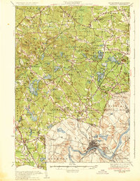
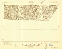 1931 Lowell1931 Print · USGSSouthern New Hampshire and northern Massachusetts met along the river and rail lines in the early thirties. Local researchers can trace family lands near St Marie Convent, the site of Musquash Sch, and the heights of Jeremy Hill.
 - 1931 Map of Groton
 1931 Groton1931 Print · USGSThe Massachusetts and New Hampshire borderlands in the early thirties reveal a landscape of river-powered rail and rural industry. Genealogists can trace family landmarks and transport hubs like Hollis Sta, Potanopa Pond, and the Runnels Bridge.
 - 1931 Map of Fitchburg
 1931 Fitchburg1931 Print · USGSThe Massachusetts and New Hampshire border region was a network of mill villages and mountain ridges in the early thirties. Genealogists and historians can locate rural landmarks like School No 8, the High Bridge, and the Boston and Maine rail line.
 - 1932 Map of Warwick
 1932 Warwick1932 Print · USGSIn the early 1930s, the tri-state border region of Massachusetts, New Hampshire, and Vermont was a vital corridor of rail and river transit. Genealogists and researchers can trace the old rail lines of the Central Vermont Ry, locate the East Northfield Sta, or find family landmarks like Curtis Corners and Wheeler Fall.
 - 1932 Map of Newburyport
 1932 Newburyport1932 Print · USGSThe New Hampshire seacoast and southern Rockingham County are shown here in the early thirties, just as coastal recreation and inland farming reached a mature balance. Genealogists can locate family-named landmarks like Nason Corner, Dearborn Academy, and various district schools.4 unique versions available
 - 1932 Map of Winchendon
 1932 Winchendon1932 Print · USGSThe borderlands of New Hampshire and Massachusetts come into focus during the early thirties, showing a rural landscape dominated by glacial lakes and high ridges. Researchers can trace the Boston and Maine line through State Line or locate family sites at Rand Cem and Sch No 1.
 - 1933 Map of Chicopee
 1933 Chicopee1933 Print · USGSThe industrial corridor of the Pioneer Valley is frozen in time during the early 1930s, showing the dense mill and residential centers along the river bends. Trace local family history through numerous landmarks like St Patrick Cem, the West Street Sch, and the grounds of the Springfield Airport.
 - 1933 Map of Feeding Hills
 1933 Feeding Hills1933 Print · USGSThe Lower Pioneer Valley in the early thirties reveals a landscape shaped by the ridge of Proven Mountain and the winding Westfield River. Genealogists and historians can locate legacy institutions like the Westfield State Sanatorium and trace local neighborhoods from Frog Bottom to Feeding Hills.
 - 1933 Map of Sagamore
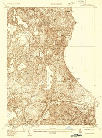 1933 Sagamore1933 Print · USGSThe Cape Cod shoreline and the recently completed canal define this area in the early 1930s. Researchers can trace the layout of coastal settlements like Sagamore Beach, locate the Indian Cem, and find industrial landmarks like Garland Bog.
 - 1933 Map of Longmeadow
 1933 Longmeadow1933 Print · USGSThe Connecticut River valley thrives in the early 1930s as a hub of industry, education, and transport. Researchers can trace historic family plots at Springfield Cemetery or locate old rail hubs like Union Station and the Longmeadow Sta.
 - 1934 Map of Plymouth
 1934 Plymouth1934 Print · USGSThe Massachusetts coast near the height of its cranberry-growing era is captured in this mid-1930s survey of the shoreline and its glacial interior. Genealogists and historians can trace the legacy of the region through landmarks like Plymouth Rock, the Plymouth Cem, and numerous family-named sites such as Bernard Shaw Bog.
 - 1934 Map of Worcester
 1934 Worcester1934 Print · USGSMid-depression Worcester and Holden emerge as a dense network of industrial ponds, institutions, and rail lines. Genealogists can trace family connections through the Grove Cem, numerous local schools like Chaffin Sch, and the neighborhoods around Union Sta.
 - 1934 Map of Exeter
 1934 Exeter1934 Print · USGSThe New Hampshire seacoast and Merrimack Valley met the Atlantic in the mid-thirties as a network of rail and river commerce. Genealogists can trace family lines through Newbury Old Town or locate historic institutions like Phillips Exeter Academy and Dearborn Academy.5 unique versions available
 - 1935 Map of Ayer
 1935 Ayer1935 Print · USGSThe intersection of Middlesex and Worcester counties in the mid-1930s reveals a landscape of military bases, historic academies, and industrial ponds. Researchers can trace the layout of Fort Devens, the grounds of the Groton School, and the unique settlement at Shaker Village.
 - 1935 Map of Mt Holyoke
 1935 Mt Holyoke1935 Print · USGSThe Connecticut River Valley's academic and agricultural landscape is captured in the mid-1930s, showing the early footprints of storied institutions. Researchers can trace the grounds of Amherst College, find the rural Smiths Ferry Ch, and locate old settlements like Pearl City and Hockanum.
 - 1935 Map of Easthampton
 1935 Easthampton1935 Print · USGSHampshire County thrives in the mid-thirties as a center of industry and institutional care along the Connecticut River. Genealogists can trace family names at the West Farms Cem or locate historic campus grounds like Williston Academy and Laurel Park.
 - 1935 Map of Warwick
 1935 Warwick1935 Print · USGSUpper Massachusetts and the Tri-State borderlands thrive during the mid-thirties as rail corridors and river valleys connect mountain villages. Researchers can trace the Central Vermont Ry through Northfield or locate family landmarks like Barrows Cem and Barber Sch.2 unique versions available
 - 1935 Map of Williamsburg
 1935 Williamsburg1935 Print · USGSThe hills of Western Massachusetts are captured here in the mid-1930s as the rail and river economy of the Pioneer Valley persisted. Researchers can trace historic schoolhouses like Poland Sch, the rail terminus at Williamsburg Station, and several family-named landmarks including Joe Herrick Hill.
 - 1935 Map of Groton
 1935 Groton1935 Print · USGSCrossing the New Hampshire border in the 1930s, this area was a bustling hub of rail transport and riverside industry. Researchers can trace the legacy of communal life at Shaker Village, locate the campus of Groton School, or follow the lines of the Boston and Maine RR through towns like Pepperell and Shirley.
 - 1935 Map of Fitchburg
 1935 Fitchburg1935 Print · USGSThe industrial corridor and border hills of north-central Massachusetts and southern New Hampshire are captured here in the mid-1930s. Trace the intricate rail networks of the Old Colony Railroad and find local landmarks like School No 8 or Rollstone Hill.3 unique versions available
 - 1935 Map of Millbury
 1935 Millbury1935 Print · USGSThe Worcester County countryside in the mid-1930s reveals a dense network of industrial hamlets and rail lines before the modern interstate era. Researchers can trace family roots at St Roche Cem or Bnai Brith Cem and locate vanished schoolhouses like the Hammond Sch.
 - 1935 Map of Wareham
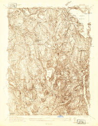
 1935 Wareham1935 Print · USGSThe cranberry bogs and rail corridors of Plymouth County are captured here in the mid-1930s before modern development altered the hydraulic landscape. Genealogists and historians can trace family-named sites and industrial markers such as Tihonet, the Center Cem, and the path of the New York New Haven and Hartford railroad.
 - 1935 Map of Lowell
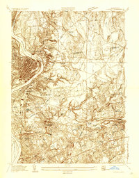
 1935 Lowell1935 Print · USGSGreater Lowell and the Merrimack Valley are captured in the mid-1930s, showing a region defined by its industrial riverfront and extensive rail networks. Researchers can trace historic neighborhoods like Wamesit, local landmarks like St Marie Convent, and early industry at Flat Rock Quarry.3 unique versions available
 - 1935 Map of Hanover
 1935 Hanover1935 Print · USGSThe northern Plymouth County ponds and woodlands are shown here in the mid-1930s as industry and early leisure began to reshape the landscape. Genealogists can trace family plots at Magoun Cem and Pine Grove Cemetery, or locate historic hubs like Schoosett and Curtis Crossing.
 - 1935 Map of Haverhill
 1935 Haverhill1935 Print · USGSThe borderlands of New Hampshire and Massachusetts appear here in the mid-1930s, showing a landscape defined by the Merrimack River and a dense rail network. Genealogists can trace family landmarks like Philbrick Hill or locate old schoolhouses including South Road Sch and the Depot Sch.5 unique versions available
Showing maps 1-25 of 83
Top cities of Massachusetts
- Boston historical maps
- Worcester historical maps
- Springfield historical maps
- Lowell historical maps
- Cambridge historical maps
- Brockton historical maps
See more
Top counties of Massachusetts
- Middlesex County historical maps
- Worcester County historical maps
- Suffolk County historical maps
- Essex County historical maps
- Norfolk County historical maps
- Bristol County historical maps
See more
Frequently asked questions
- What are the different types of historical maps available for Massachusetts?
- What is the oldest map of Massachusetts?
- Where can I purchase historical maps of Massachusetts for my home or office?
- Where can I download high-res historical maps of Massachusetts?
- Are there historical topographic maps available for Massachusetts?
- Is there historical aerial imagery available for Massachusetts?
- Where are historical maps of Massachusetts sourced from?