Old Maps of Acapesket, Falmouth for Genealogy
Trace your family roots with 26 historic maps of Acapesket. These high-res maps reveal old neighborhoods, homesites, landmarks, and streets — helping you uncover where your ancestors lived and how the area evolved over time.
- Explore historic neighborhoods: Identify where your relatives may have lived in the 1800s or 1900s.
- Compare maps over time: Trace the changes in streets, buildings, and landmarks for multi-generational research.
- Perfect for genealogy & ancestry research: Used by family historians and researchers to map out lineage and migration.
These maps are an incredible resource for exploring your personal connection to Acapesket's past.
Acapesket, Falmouth maps
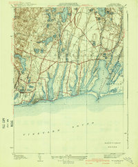
(26)- 1886 Map of Falmouth
 1886 Falmouth1886 Print · USGSThe Cape Cod peninsula during the late nineteenth century shows a landscape transitioning between maritime tradition and rail-driven growth. Genealogists can trace family footprints in Waquoit Village, Teaticket, and Menauhant while following the Old Colony Railroad corridor.
 - 1888 Map of Falmouth
 1888 Falmouth1888 Print · USGSThe Buzzards Bay coastline and upper Cape Cod are captured here in the late nineteenth century, documenting the critical arrival of the railroad. Researchers can trace the Old Colony Railroad to its terminus at Woods Holl or locate maritime landmarks like Wing's Neck Light.
 - 1893 Map of Falmouth
 1893 Falmouth1893 Print · USGSCape Cod's western shore and the upper reaches of Buzzards Bay are captured here in the late nineteenth century as rail travel transformed the coast. Genealogists can trace family names at Waquoit Village or follow the Old Colony Railroad through Woods Holl and Falmouth Station.9 unique versions available
 - 1915 Map of Falmouth, 1943 Print
 1915 Falmouth1943 Print · USGSUpper Cape Cod during the mid-forties reveals a landscape of growing military activity alongside traditional coastal villages. Genealogists and historians can trace the foundations of Camp Edwards and find historic post offices at Waquoit Village or Monument Beach.
 - 1920 Map of Falmouth
 1920 Falmouth1920 Print · USGSCoastal Barnstable County comes to life in this post-war military survey of the Falmouth peninsula and its maritime approaches. Researchers can trace the Old Colony RR to Falmouth Station or locate landmarks like Nobska Point Light and Waquoit Village.
 - 1936 Map of Falmouth
 1936 Falmouth1936 Print · USGSCoastal Barnstable County is documented here in the mid-1930s, showing the early layouts of seaside villages and their surrounding finger ponds. Genealogists and historians can trace the foundations of Falmouth Heights, Waquoit Village, and the Harbor Lighthouse.
 - 1941 Map of Falmouth
 1941 Falmouth1941 Print · USGSCape Cod's south shore appears just before the mid-century boom, showing the maritime and residential character of the 1930s. Genealogists and historians can trace family-named areas like Smarttown, old congregations at East End Ch, and the development of Waquoit Village.3 unique versions available
 - 1942 Map of New Bedford
 1942 New Bedford1942 Print · USGSSoutheastern Massachusetts at the start of the 1940s shows a region defined by maritime defense and industrial rail corridors. Genealogists and historians can trace the massive Camp Edwards boundary, old rail stops like Rock Station, and vanished local industry at Paper Mill Village.2 unique versions available
 - 1946 Map of Falmouth, 1954 Print
 1946 Falmouth1954 Print · USGSUpper Cape Cod's coastline and interior ponds are captured in detail during the mid-1940s, showing the early growth of seaside summer communities. Genealogists and historians can trace family roots through settlements like Teaticket, Mara Vista, and Waquoit Village before later modern development.2 unique versions available
 - 1947 Map of Providence, 1948 Print
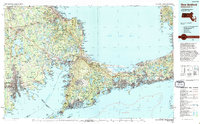
 1947 Providence1948 Print · USGSSouthern New England is captured in the mid-1940s, showing a landscape defined by busy industrial ports and expanding military installations. Researchers can trace the rail lines of the N.Y. N.H. & H. RR or locate coastal defenses like Fort Adams and Quonset Point.5 unique versions available
 - 1948 Map of Falmouth, 1949 Print
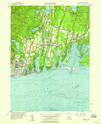
 1948 Falmouth1949 Print · USGSThe Falmouth coastline and the interior ponds of Cape Cod are shown here just after the war. Researchers can trace family history through sites like Oak Grove Cemetery, St Anthonys Church, and the vanished lanes of Smalltown.
 - 1948 Map of Providence, 1951 Print
 1948 Providence1951 Print · USGSSouthern New England’s coastal reaches are captured here in the late 1940s, from the industrial heart of Providence to the tip of Provincetown. Genealogists and historians can trace rail lines like the Central Vermont Railway and locate active military sites such as Otis Air Force Base and Fort Rodman.
 - 1949 Map of Falmouth
 1949 Falmouth1949 Print · USGSThe southern coast of Cape Cod comes alive in this post-war mosaic, showing a landscape of cranberry bogs and seasonal colonies. Trace old family plots at Oak Grove Cem or explore coastal reaches like Seconsett Island and Waquoit Village.
 - 1957 Map of Providence
 1957 Providence1957 Print · USGSCoastal New England at the height of the mid-century era shows a landscape shaped by maritime industry and Cold War defense. Genealogists and historians can trace the reach of the New York, New Haven & Hartford RR and locate legacy sites like Fort Adams and Quonset Point Naval Air Station.
 - 1957 Map of Falmouth, 1958 Print
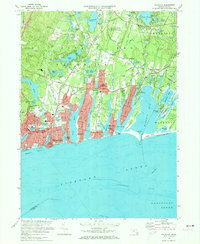
 1957 Falmouth1958 Print · USGSCoastal Barnstable County comes alive in this mid-century portrait of established seaside villages and seasonal shorefront developments. Genealogists and historians can trace neighborhood growth through Waquoit Village, locate St Patricks Cath Ch, and find long-standing family Cranberry Bogs.3 unique versions available
 - 1958 Map of Providence
 1958 Providence1958 Print · USGSThe Rhode Island and Massachusetts coastlines are shown in detail during the late 1950s, from the urban cores to the tips of the islands. Researchers can trace the mid-century footprint of Quonset Point Naval Air Station, the defense works at Fort Adams, and the rail network of the New York, New Haven and Hartford RR.
 - 1963 Map of Providence
 1963 Providence1963 Print · USGSSouthern New England's coastal and industrial heartland is captured here in the early sixties, from the Rhode Island mainland to the far reaches of the Cape. Researchers can trace mid-century growth in Providence or locate landmarks on Marthas Vineyard and Nantucket Island.
 - 1972 Map of Falmouth, 1974 Print
 1972 Falmouth1974 Print · USGSCoastal Barnstable County is documented here in the early seventies, capturing the intricate shoreline and residential growth of the Cape. Genealogists and local historians can locate specific landmarks including St Patricks Ch, Oak Grove Cem, and the Lawrence High Sch.3 unique versions available
 - 1977 Map of Falmouth, 1981 Print
 1977 Falmouth1981 Print · USGSThe southern coast of the Cape during the late 1970s reveals a landscape of growing residential grids and winding coastal inlets. Researchers can trace the development of Falmouth and Teaticket or study the shorelines of Acapesket.
 - 1986 Map of New Bedford
 1986 New Bedford1986 Print · USGSSoutheastern Massachusetts and the Cape are shown here during the mid-eighties, a period of notable coastal growth and modernization. Researchers can trace the development of maritime hubs like Woods Hole and New Bedford or locate landmarks within Myles Standish State Forest.
 - 1994 Map of New Bedford
 1994 New Bedford1994 Print · USGSSoutheastern Massachusetts and the Cape are shown in high detail during the mid-nineties, capturing the region's unique maritime geography and coastal infrastructure. Trace the transition from the industrial New Bedford Harbor to protected lands like Cape Cod National Seashore and Otis Air Force Base.
 - 2012 Map of Falmouth, 2012 Print
 2012 Falmouth2012 Print · USGSCovers Acapesket, including Falmouth, Mashpee, and other nearby areas
 - 2015 Map of Falmouth, 2015 Print
 2015 Falmouth2015 Print · USGSCovers Acapesket, including Falmouth, Mashpee, and other nearby areas
 - 2018 Map of Falmouth, 2018 Print
 2018 Falmouth2018 Print · USGSCovers Acapesket, including Falmouth, Mashpee, and other nearby areas
 - 2021 Map of Falmouth, 2021 Print
 2021 Falmouth2021 Print · USGSCovers Acapesket, including Falmouth, Mashpee, and other nearby areas
Showing maps 1-25 of 26
Top cities near Acapesket
- Plymouth historical maps
- Falmouth historical maps
- Wareham historical maps
- Sandwich historical maps
- Bourne historical maps
- Mashpee historical maps
See more
Frequently asked questions
- What are the different types of historical maps available for Acapesket?
- What is the oldest map of Acapesket?
- Where can I purchase historical maps of Acapesket for my home or office?
- Where can I download high-res historical maps of Acapesket?
- Are there historical topographic maps available for Acapesket?
- Is there historical aerial imagery available for Acapesket?
- Where are historical maps of Acapesket sourced from?