1950s Maps of Powell County, Montana
Explore 10 historic maps of Powell County from the 1950s. These maps offer a rare glimpse into what life looked like during the 1950s — showing old roads, neighborhoods, homes, and landmarks that have changed or disappeared over time.
Whether you're researching your family's past, planning a metal detecting trip, or studying how Powell County's landscape evolved across the 1950s, these high-resolution maps are a powerful tool for exploring the history of this region.
- Focus on a specific era: All maps on this page are from the 1950s, giving you a focused view of this time period.
- See what’s changed: Compare century-old streets, trails, and buildings to today's modern landscape using overlays and satellite layers.
- Research with precision: Use these maps for genealogy, historical research, land use analysis, or educational projects.
- View, download, or print: Maps are fully viewable online in high resolution, and can be downloaded or printed for your own records.
Start exploring Powell County's history through authentic maps from the 1950s. This is your window into the past.
Powell County, MT maps
(10)- 1954 Map of Basin, 1956 Print
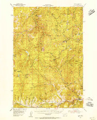 1954 Basin1956 Print · USGSJefferson and Powell Counties were centers of intense mountain industry in the mid-fifties, linked by the GREAT NORTHERN rail line. Researchers can trace dozens of individual lode and placer operations, including the Monarch Mine, Bullion Mine, and the local rail hub at Basin.3 unique versions available
 - 1955 Map of Choteau, 1978 Print
 1955 Choteau1978 Print · USGSWestern Montana during the mid-fifties is captured here as a land of rugged high-country wilderness and vital eastern plains irrigation. Genealogists and historians can locate remote outposts like Condon, the communal Miller Colony, and the rail stops of the Chicago Milwaukee St Paul and Pacific.
 - 1957 Map of Choteau
 1957 Choteau1957 Print · USGSMontana's mountain front meets the eastern plains in the mid-fifties, showing the transition from forested wilderness to irrigated ranch land. Genealogists and historians can trace the rail lines of the Great Northern and find settlements like Choteau, Augusta, and Seeley Lake.
 - 1958 Map of Butte
 1958 Butte1958 Print · USGSWestern Montana's mining and rail corridors are captured in the late fifties, from the urban bustle of the Copper King cities to high mountain passes. Researchers can trace the path of the Milwaukee St Paul and Pacific through Deer Lodge and locate remote outposts like Potomac Post Office.5 unique versions available
 - 1958 Map of Choteau
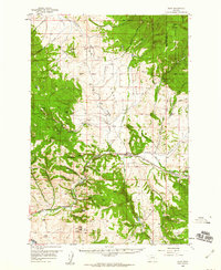
 1958 Choteau1958 Print · USGSMontana's front range meets the high wilderness in the late fifties, where the Great Northern railway connects ranching towns to the eastern plains. Researchers can trace the development of irrigation at Bynum Reservoir or locate remote camps like the Big Prairie District Ranger Station and Helmville.2 unique versions available
 - 1958 Map of Avon, 1960 Print
 1958 Avon1960 Print · USGSThe Little Blackfoot River valley was a vital transport corridor in the late 1950s, bridging the gap between ranching lands and the high timber of the Helena National Forest. Researchers can trace the legacy of the mining era at Blackfoot City (Ghost Town) and locate landmarks like the Shearing Plant and Lost Cabin.4 unique versions available
 - 1958 Map of Drummond, 1960 Print
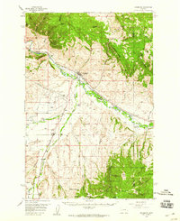 1958 Drummond1960 Print · USGSDrummond and the surrounding Clark Fork valley are captured here in the late fifties, showcasing a critical Montana rail and river corridor. Genealogists and rail historians can trace the paths of the Northern Pacific through settlements like New Chicago and Hall.3 unique versions available
 - 1958 Map of Garrison, 1960 Print
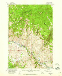 1958 Garrison1960 Print · USGSThe confluence of the Clark Fork and Little Blackfoot River defined this late-fifties Montana rail corridor. Genealogists and historians can trace the legacy of the Northern Pacific through towns like Garrison, find Placer Mines in the gulches, and locate the vanished site of Wall City.3 unique versions available
 - 1959 Map of Deer Lodge, 1961 Print
 1959 Deer Lodge1961 Print · USGSDeer Lodge and the Clark Fork valley are captured here in the late fifties, showcasing a landscape defined by parallel transcontinental railroads and mountain mining. Genealogists and historians can trace the foundations of Deer Lodge, the State Prison, and isolated settlements like Leadville.2 unique versions available
 - 1959 Map of Elliston, 1961 Print
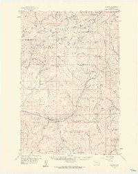 1959 Elliston1961 Print · USGSThe mountain passes of the Continental Divide appear in great detail here in the late fifties as the mining and railroad era evolved. Local historians can trace the Northern Pacific line past Blossburg or locate old operations like the Strawberry Mine and Ophir Cave.3 unique versions available
End of results
Showing maps 1-10 of 10
Top cities of Powell County
Frequently asked questions
- What are the different types of historical maps available for Powell County?
- What is the oldest map of Powell County?
- Where can I purchase historical maps of Powell County for my home or office?
- Where can I download high-res historical maps of Powell County?
- Are there historical topographic maps available for Powell County?
- Is there historical aerial imagery available for Powell County?
- Where are historical maps of Powell County sourced from?