1990s Maps of Powell County, Montana
Explore 37 historic maps of Powell County from the 1990s. These maps offer a rare glimpse into what life looked like during the 1990s — showing old roads, neighborhoods, homes, and landmarks that have changed or disappeared over time.
Whether you're researching your family's past, planning a metal detecting trip, or studying how Powell County's landscape evolved across the 1990s, these high-resolution maps are a powerful tool for exploring the history of this region.
- Focus on a specific era: All maps on this page are from the 1990s, giving you a focused view of this time period.
- See what’s changed: Compare century-old streets, trails, and buildings to today's modern landscape using overlays and satellite layers.
- Research with precision: Use these maps for genealogy, historical research, land use analysis, or educational projects.
- View, download, or print: Maps are fully viewable online in high resolution, and can be downloaded or printed for your own records.
Start exploring Powell County's history through authentic maps from the 1990s. This is your window into the past.
Powell County, MT maps
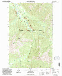
(37)- 1993 Map of Dearborn River
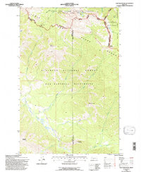
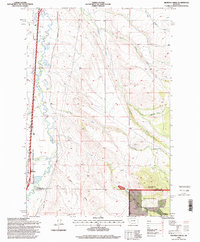
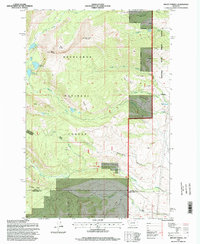
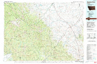 1993 Dearborn River1993 Print · USGSThe Montana wilderness and the Front Range come alive in this early 1990s overview of the high country near Augusta. Outdoor historians and researchers can trace the Continental Divide Trail or locate remote sites like Copper Camp and Milford Colony.
 - 1993 Map of Seeley Lake
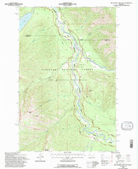
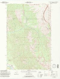
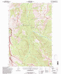
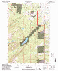
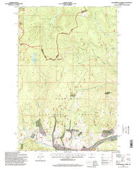
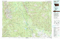 1993 Seeley Lake1993 Print · USGSThe Seeley Lake region in the early nineties is shown here as a landscape defined by its great wilderness boundaries and glacial waters. Researchers can trace the layout of Seeley Lake, the remote Danaher Guard Station, and historic routes like Montana 200 near Ovando.
 - 1993 Map of Philipsburg, 1994 Print
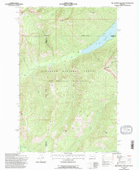
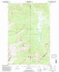
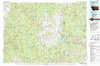 1993 Philipsburg1994 Print · USGSThe mining and mountain country of Granite County is captured in the early nineties, showing a landscape defined by timber and mineral wealth. You can trace historical mining operations at the Black Pine Mine and Cable Mine or locate early settlements like Maxville and Southern Cross.
 - 1994 Map of Butte North
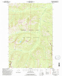
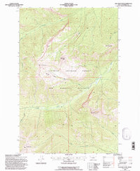
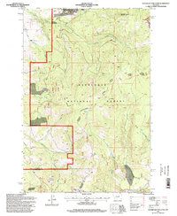
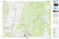 1994 Butte North1994 Print · USGSWestern Montana in the nineties was a landscape defined by ranching legacy and high-altitude mining. Genealogists and historians can trace institutional history at the Deer Lodge Prison Farm or locate old claims like the Saratoga Mine and Morning Glory Mine.
 - 1994 Map of Pilot Peak, 1997 Print
 1994 Pilot Peak1997 Print · USGSThe Montana backcountry within the Bob Marshall Wilderness is documented here during the mid-1990s. Researchers can locate remote landmarks like the Hahn Creek Cabin, Hole in the Wall Cave, and the summit of Pilot Peak.
 - 1994 Map of Big Salmon Lake East, 1997 Print
 1994 Big Salmon Lake East1997 Print · USGSThe Montana backcountry remains wild and preserved in the mid-1990s, dominated by the Bob Marshall Wilderness. Researchers can trace the path of National Forest Trail 112 past Holbrook Cabin and across the White River.
 - 1994 Map of Big Salmon Lake West, 1997 Print
 1994 Big Salmon Lake West1997 Print · USGSBig Salmon Lake and the surrounding wilderness are documented here in the mid-1990s as they transitioned into modern forest management. Researchers can locate remote backcountry landmarks like Pendant Cabin, Patrol Point, and the waters of Big Salmon Lake.
 - 1994 Map of Crimson Peak, 1997 Print
 1994 Crimson Peak1997 Print · USGSThe Montana backcountry remains preserved in the mid-nineties within the high peaks and wilderness boundaries of Flathead County. Researchers can trace primitive routes like the Seeley Lake Spotted Bear Rd and locate remote landmarks including Crimson Lake and Leota Park.
 - 1994 Map of Trap Mountain, 1997 Print
 1994 Trap Mountain1997 Print · USGSThe Lewis and Clark Range remained a primitive wilderness in the 1990s, where the Continental Divide meets the Bob Marshall and Scapegoat Wilderness areas. Researchers can trace high-altitude navigation routes like the Continental Divide Trail and locate the remote Basin Creek Cabin.
 - 1994 Map of Haystack Mountain, 1997 Print
 1994 Haystack Mountain1997 Print · USGSThe high Montana backcountry of the mid-1990s is captured here, tracing the rugged divide where the Bob Marshall Wilderness meets the Flathead Alps. Researchers can locate remote outposts like the Big Prairie Work Center and high-altitude crossings at White River Pass.2 unique versions available
 - 1994 Map of Danaher Mountain, 1997 Print
 1994 Danaher Mountain1997 Print · USGSIn the mid-1990s, the high mountain divide between Powell and Lewis and Clark counties remained a primitive wilderness sanctuary. Researchers can trace remote alpine trails and landmarks like Danaher Cabin, Limestone Pass, and the summit of Danaher Mountain.
 - 1994 Map of Una Mountain, 1997 Print
 1994 Una Mountain1997 Print · USGSThe Montana backcountry in the mid-1990s reveals a landscape of high summits and protected wilderness. Outdoorsmen and researchers can trace the drainages of Gordon Creek or locate landmarks like Una Mountain and the remote Nannie Basin.
 - 1995 Map of Prairie Reef, 1997 Print
 1995 Prairie Reef1997 Print · USGSThe high peaks of the Lewis and Clark Range dominate this mid-nineties survey of the Montana wilderness. Researchers can trace the winding Continental Divide and locate remote landmarks like Indian Point, Hermit Lake, and the summit of Prairie Reef.
 - 1996 Map of Orofino Creek, 1998 Print
 1996 Orofino Creek1998 Print · USGSWestern Montana's high country and the Clark Fork valley are documented here in the mid-nineties as they appeared before major modern shifts. Researchers can trace the drainage of Orofino Creek and locate several high-elevation mining Prospects near O'Donnell Mountain.
 - 1996 Map of Griffin Creek, 1998 Print
 1996 Griffin Creek1998 Print · USGSSettlement and industry meet the mountain landscape in the 1990s near the Clark Fork. Researchers can trace old mining footprints at Wall City and find family-named landmarks like Pioneer Gulch and the Montana State Prison Ranch.
 - 1996 Map of Baggs Creek, 1998 Print
 1996 Baggs Creek1998 Print · USGSPowell County's mining and forest lands are documented in detail here during the late twentieth century. You can trace industrial sites like the Hidden Hand Mine or locate early water sources such as Spotted Dog Creek and Freezeout Creek.
 - 1996 Map of Rock Creek Lake, 1998 Print
 1996 Rock Creek Lake1998 Print · USGSPowell County's high-country terrain is captured here in the mid-1990s, where national forest land meets the unique boundary of the State Prison Ranch. Researchers can trace old mountain infrastructure including the Rock Creek Ditch, the Doney Lake Cabin (USFS), and the secluded South America Park.
 - 1996 Map of Mount Powell, 1998 Print
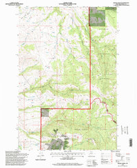
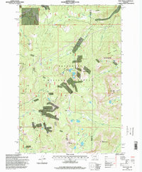
 1996 Mount Powell1998 Print · USGSHigh in the Deer Lodge National Forest during the late nineties, this area showcases the intersection of public lands and the Montana State Prison Ranch Boundary. Researchers can trace old mining efforts at Prospect sites or explore routes along the Dempsey Creek Trail and Racetrack Trail.
 - 1996 Map of Pozega Lakes, 1998 Print
 1996 Pozega Lakes1998 Print · USGSHigh in the Deerlodge National Forest during the late nineties, this landscape shows the intersection of alpine wilderness and industrial history. Researchers can trace the layout of the Danielsville (Site) or locate mountain operations like Powell Mines and the Tungsten Mine.
 - 1996 Map of Deer Lodge, 1998 Print
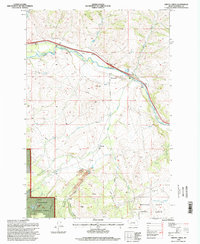
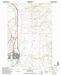 1996 Deer Lodge1998 Print · USGSDeer Lodge and the surrounding valley are captured here in the mid-1990s, where ranching heritage meets modern civic life. Genealogists and researchers can locate the Courthouse and local schools, or explore the Grant Kohrs Ranch National Historic Site along the Clark Fork.
 - 1996 Map of Racetrack, 1998 Print
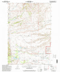
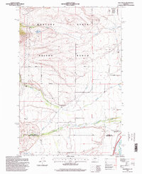 1996 Racetrack1998 Print · USGSPowell County ranching and institutional history are revealed in this mid-nineties survey of the Deer Lodge Valley foothills. Researchers can trace the extensive grounds of the Montana State Prison Ranch and find local landmarks such as Perkins Ranch, Ryan, and Racetrack.
 - 1996 Map of Thunderbolt Creek, 1998 Print
 1996 Thunderbolt Creek1998 Print · USGSThe Continental Divide in the mid-1990s remained a remote landscape of mining claims and forest boundaries. You can trace early mineral exploration at the Saratoga Mine and numerous Prospect sites near Iron Mountain and Thunderbolt Mountain.
 - 1996 Map of Sugarloaf Mountain, 1998 Print
 1996 Sugarloaf Mountain1998 Print · USGSHigh in the Montana backcountry during the 1990s, this area shows the rugged intersection of mining history and wilderness recreation. Researchers can trace old resource extraction sites like Schurchs Tunnel and Leadville alongside the Continental Divide National Scenic Trail.
 - 1996 Map of Pikes Peak, 1998 Print
 1996 Pikes Peak1998 Print · USGSThe Flint Creek Range of western Montana is shown here in the mid-1990s, revealing a landscape defined by high-altitude mining and national forest lands. Researchers can trace historic extraction sites like the Master Mining Camp, Port Royal Mines, and Thursday-Friday Mine.
 - 1996 Map of Conleys Lake, 1998 Print
 1996 Conleys Lake1998 Print · USGSDeer Lodge and the surrounding Powell County valley are captured here in the mid-1990s as a landscape of institutional ranching and historic preservation. Trace the sprawling Montana State Prison Ranch, the Grant-Kohrs National Historic Site, and family landmarks like Williams and Tavernier Ranch.
Showing maps 1-25 of 37
Top cities of Powell County
Frequently asked questions
- What are the different types of historical maps available for Powell County?
- What is the oldest map of Powell County?
- Where can I purchase historical maps of Powell County for my home or office?
- Where can I download high-res historical maps of Powell County?
- Are there historical topographic maps available for Powell County?
- Is there historical aerial imagery available for Powell County?
- Where are historical maps of Powell County sourced from?