1970s Maps of Powell County, Montana
Explore 17 historic maps of Powell County from the 1970s. These maps offer a rare glimpse into what life looked like during the 1970s — showing old roads, neighborhoods, homes, and landmarks that have changed or disappeared over time.
Whether you're researching your family's past, planning a metal detecting trip, or studying how Powell County's landscape evolved across the 1970s, these high-resolution maps are a powerful tool for exploring the history of this region.
- Focus on a specific era: All maps on this page are from the 1970s, giving you a focused view of this time period.
- See what’s changed: Compare century-old streets, trails, and buildings to today's modern landscape using overlays and satellite layers.
- Research with precision: Use these maps for genealogy, historical research, land use analysis, or educational projects.
- View, download, or print: Maps are fully viewable online in high resolution, and can be downloaded or printed for your own records.
Start exploring Powell County's history through authentic maps from the 1970s. This is your window into the past.
Powell County, MT maps
(17)- 1970 Map of Crimson Peak, 1973 Print
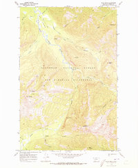
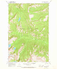
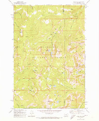
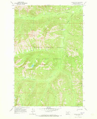 1970 Crimson Peak1973 Print · USGSIn the early 1970s, this area of Powell County remained a preserved backcountry of the Bob Marshall Wilderness. Hikers and researchers can trace the original routes of the Blackfoot Divide Trail (Track) and find landmarks like Crimson Lake and Youngs Pass.2 unique versions available
 - 1970 Map of Danaher Mountain, 1973 Print
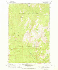
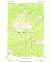
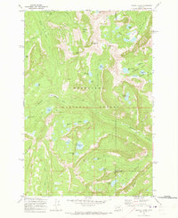
 1970 Danaher Mountain1973 Print · USGSThe Bob Marshall Wilderness in the early 1970s remained a remote landscape of pack trails and alpine summits. Researchers can trace historic mountain routes like the Hahn Creek Trail and locate the isolated Danaher Guard Station near Danaher Meadows.2 unique versions available
 - 1970 Map of Big Salmon Lake East, 1973 Print
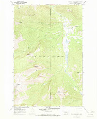
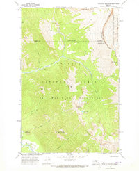
 1970 Big Salmon Lake East1973 Print · USGSThe Bob Marshall Wilderness during the 1970s reveals a vast landscape managed by the Forest Service before modern development. Trace the remote network of Pack Trails connecting Holbrook Guard Sta and fords along the South Fork Flathead River.
 - 1970 Map of Prairie Reef, 1973 Print
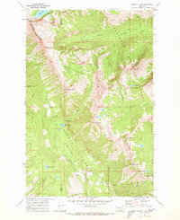
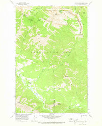
 1970 Prairie Reef1973 Print · USGSThe Bob Marshall Wilderness and Sun River Game Preserve are captured here in the early 1970s. Trace the Continental Divide and find remote outposts like the Indian Point Guard Sta and the Prairie Reef Lookout.3 unique versions available
 - 1970 Map of Pilot Peak, 1973 Print
 1970 Pilot Peak1973 Print · USGSThe Bob Marshall Wilderness in the early seventies remained a realm of backcountry trails and remote river forks. Map collectors and hikers can trace the original Hahn Creek Trail and locate isolated landmarks like the Hole-in-the-Wall Cave or the Hahn Creek Guard Sta.2 unique versions available
 - 1970 Map of Hahn Creek Pass, 1973 Print
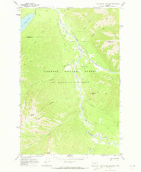
 1970 Hahn Creek Pass1973 Print · USGSThe high divide of the Powell County backcountry is captured here in the early 1970s. Researchers can trace the primitive Pack Trail network through the Bob Marshall Wilderness to landmarks like Hahn Creek Pass and Monture Falls.
 - 1970 Map of Haystack Mountain, 1973 Print
 1970 Haystack Mountain1973 Print · USGSPowell County and the high mountain passes of western Montana are captured here during the 1970s. Trace the path of the Continental Divide and find remote sites like the Work Center, Needle Falls, and Prisoner Lake.
 - 1970 Map of Morrell Lake, 1973 Print
 1970 Morrell Lake1973 Print · USGSThe high Divide country of the Mission and Swan ranges appears in 1970 just as it was being managed as a vast wilderness crossroads. Trace the historic footpaths through the high country including the Pyramid Pass Trail and remote waters like Morrell and George Lake.2 unique versions available
 - 1970 Map of Shaw Creek, 1973 Print
 1970 Shaw Creek1973 Print · USGSPowell County and the primitive Bob Marshall Wilderness are captured in the early 1970s, showing a landscape defined by horse trails and remote peaks. Trace historic routes like the Big Salmon Pack Trail to landmarks like the Shaw Creek Guard Sta.3 unique versions available
 - 1970 Map of Una Mountain, 1973 Print
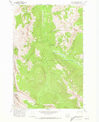
 1970 Una Mountain1973 Print · USGSThe high wilderness of Powell County is captured here in the early seventies, just as modern photogrammetric mapping reached these remote peaks. Trace primitive routes like the Bartlett Creek Pack Trail between Una Mountain and Cardinal Peak.
 - 1970 Map of Trap Mountain, 1973 Print
 1970 Trap Mountain1973 Print · USGSThe Continental Divide and the Bob Marshall Wilderness meet in this 1970s survey of the Montana high country. Backcountry researchers can trace the Jumbo Lookout Trail, the Basin Creek Guard Station, and landmarks like Hoadley Reef.2 unique versions available
 - 1970 Map of Big Salmon Lake West, 1973 Print
 1970 Big Salmon Lake West1973 Print · USGSMontana's high backcountry comes alive in the early seventies, detailing the primitive reaches of the Bob Marshall Wilderness. Trace the network of Pack Trails and Foot Trails connecting Pendant Guard Sta to Salmon Point.2 unique versions available
 - 1971 Map of Pikes Peak, 1973 Print
 1971 Pikes Peak1973 Print · USGSThe high country of the Deerlodge National Forest is captured here in the early 1970s during a period of active exploration. You can locate remote sites like the Master Mining Camp and trace old routes to the Thursday Friday Mine and Port Royal Mines.2 unique versions available
 - 1971 Map of Pozega Lakes, 1973 Print
 1971 Pozega Lakes1973 Print · USGSThe high Flint Creek Range comes into focus in the early 1970s, showing a landscape of alpine lakes and rugged mining prospects. You can trace early routes like the Racetrack Trail to the Powell Mines or the small settlement at Danielsville.2 unique versions available
 - 1975 Map of Elliston, 1993 Print
 1975 Elliston1993 Print · USGSWestern Montana's rugged high-country comes into focus during the mid-seventies, showing the intersection of heavy industry and wilderness. Genealogists and historians can trace rail lines like the Milwaukee Road and locate remote sites such as the Swansea Mine or Wall City.
 - 1976 Map of Choteau
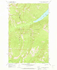
 1976 Choteau1976 Print · USGSThe Montana Rocky Mountain Front meets the plains in the 1970s, showcasing the high-altitude wilderness and the irrigation-fed ranching country. Trace the Great Northern Railway through Choteau or locate rural landmarks like the Farmington Cemetery and Gibson Reservoir.
 - 1976 Map of Racetrack, 1981 Print
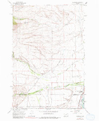 1976 Racetrack1981 Print · USGSUpper Powell County is captured in the mid-1960s, showing a landscape defined by ranching and high-country drainage. Genealogists and historians can locate the Perkins Ranch and follow the rugged path of Morrison Gulch through the mountains.
End of results
Showing maps 1-17 of 17
Top cities of Powell County
Frequently asked questions
- What are the different types of historical maps available for Powell County?
- What is the oldest map of Powell County?
- Where can I purchase historical maps of Powell County for my home or office?
- Where can I download high-res historical maps of Powell County?
- Are there historical topographic maps available for Powell County?
- Is there historical aerial imagery available for Powell County?
- Where are historical maps of Powell County sourced from?