1920s Maps of Nevada
Explore 13 historic maps of Nevada from the 1920s. These maps offer a rare glimpse into what life looked like during the 1920s — showing old roads, neighborhoods, homes, and landmarks that have changed or disappeared over time.
Whether you're researching your family's past, planning a metal detecting trip, or studying how Nevada's landscape evolved across the 1920s, these high-resolution maps are a powerful tool for exploring the history of this region.
- Focus on a specific era: All maps on this page are from the 1920s, giving you a focused view of this time period.
- See what’s changed: Compare century-old streets, trails, and buildings to today's modern landscape using overlays and satellite layers.
- Research with precision: Use these maps for genealogy, historical research, land use analysis, or educational projects.
- View, download, or print: Maps are fully viewable online in high resolution, and can be downloaded or printed for your own records.
Start exploring Nevada's history through authentic maps from the 1920s. This is your window into the past.
Nevada maps
- 1920 Map of Bridgeport
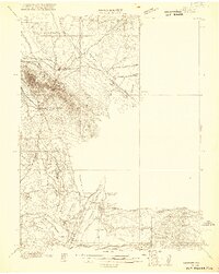
 1920 Bridgeport1920 Print · USGSThe High Sierra and Mono Basin are shown here in the early twentieth century, during a peak period of mining and ranching. Researchers can locate vanished camps like Star City, trace the California Masonic Road, and find family names at Conway Ranch.
 - 1921 Map of NW 1/4 Panaca
 1921 NW 1/4 Panaca1921 Print · USGSLincoln County mining and desert ranching are preserved here during the peak of the silver-lead era. Genealogists and historians can trace the paths of the Pacific (Narrow Gauge) railroad and locate family landmarks like Newman Ranch and Bullionville.2 unique versions available
 - 1926 Map of Nelson
 1926 Nelson1926 Print · USGSThe Colorado River borderlands in the mid-twenties appear here as a landscape of desert canyons and future infrastructure. Researchers can trace the original river course through Eldorado Canyon and locate early sites like Nelson and the Middle Black Canyon Dam Site.
 - 1926 Map of Mohave City
 1926 Mohave City1926 Print · USGSThe Colorado River borderlands in the mid-twenties reveal a landscape of mining claims and early desert ranching before the era of modern dams. Researchers can trace the Arrowhead Trail south from Searchlight and locate family landmarks like the D Hutton Ranch or the Piute mine.
 - 1926 Map of Bonelli
 1926 Bonelli1926 Print · USGSThe Nevada-Arizona borderlands are captured here in the mid-1920s, showing the original river-crossing culture before the landscape was submerged. Researchers can trace the river economy through Bonelli Ferry, the settlement at St Thomas, and local mining at the Calico Salt Mine.
 - 1926 Map of Boulder Canyon
 1926 Boulder Canyon1926 Print · USGSBefore the completion of the Hoover Dam, this 1920s survey documents the Colorado River basin and its burgeoning infrastructure. Researchers can trace early railroad stops at Apex and Garnet, or locate the original Boulder Canyon Dam Site and Bonelli landing.2 unique versions available
 - 1926 Map of Roberts Mountains, 1955 Print
 1926 Roberts Mountains1955 Print · USGSCentral Nevada in the mid-1920s is a landscape of remote mountain ranges and isolated valley ranching. Genealogists and historians can trace family-named locations like Hall Creek Ranch, Sadler Sch, and the Keystone Mine across the high desert.
 - 1929 Map of Roberts Mountains
 1929 Roberts Mountains1929 Print · USGSCentral Nevada in the late 1920s reveals a vast ranching and mining landscape organized around vital water sources. Researchers can trace early family outposts like Roberts Creek Ranch and Grubbs Ranch or locate remote schools such as Simpson Park Sch.4 unique versions available
End of results
Showing maps 1-8
Top cities of Nevada
- Las Vegas historical maps
- Henderson historical maps
- Reno historical maps
- North Las Vegas historical maps
- Enterprise historical maps
- Spring Valley historical maps
See more
Top counties of Nevada
- Clark County historical maps
- Washoe County historical maps
- Carson City historical maps
- Lyon County historical maps
- Elko County historical maps
- Douglas County historical maps
See more
Frequently asked questions
- What are the different types of historical maps available for Nevada?
- What is the oldest map of Nevada?
- Where can I purchase historical maps of Nevada for my home or office?
- Where can I download high-res historical maps of Nevada?
- Are there historical topographic maps available for Nevada?
- Is there historical aerial imagery available for Nevada?
- Where are historical maps of Nevada sourced from?