1930s Maps of Nevada
Explore 46 historic maps of Nevada from the 1930s. These maps offer a rare glimpse into what life looked like during the 1930s — showing old roads, neighborhoods, homes, and landmarks that have changed or disappeared over time.
Whether you're researching your family's past, planning a metal detecting trip, or studying how Nevada's landscape evolved across the 1930s, these high-resolution maps are a powerful tool for exploring the history of this region.
- Focus on a specific era: All maps on this page are from the 1930s, giving you a focused view of this time period.
- See what’s changed: Compare century-old streets, trails, and buildings to today's modern landscape using overlays and satellite layers.
- Research with precision: Use these maps for genealogy, historical research, land use analysis, or educational projects.
- View, download, or print: Maps are fully viewable online in high resolution, and can be downloaded or printed for your own records.
Start exploring Nevada's history through authentic maps from the 1930s. This is your window into the past.
Nevada maps
- 1931 Map of Lovelock, 1955 Print
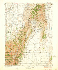
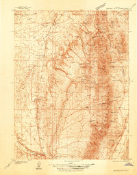
 1931 Lovelock1955 Print · USGSPershing County's high-desert mining landscape is frozen in time during the early 1930s, as gold and tungsten districts drove the local economy. Genealogists and historians can trace the foundations of Unionville, the industrial footprint of the Nevada Massachusetts Tungsten Mine, and the route of the Victory Highway.
 - 1932 Map of Truckee
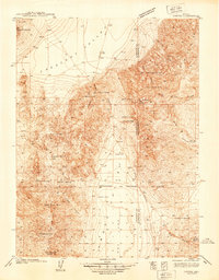
 1932 Truckee1932 Print · USGSThe high Sierra and Lake Tahoe's western shore are captured here in the early thirties as the region balanced industrial mining and timber with a growing seasonal economy. Trace early lakeside developments from Tahoe Tavern to Meeks Bay PO, or locate historical sites like the Walker Mine and Donner Monument.
 - 1932 Map of Sonoma Range, 1955 Print
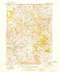
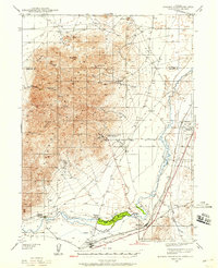
 1932 Sonoma Range1955 Print · USGSNorthern Nevada in the early thirties is captured here along the Humboldt River and its flanking desert ranges. Genealogists and historians can trace numerous family-named landmarks like Prida Ranch and Childress Ranch, or locate the Site of Old Indian Fort and Barber Sch.5 unique versions available
 - 1934 Map of Jiggs, 1955 Print
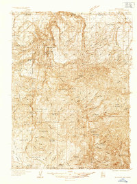
 1934 Jiggs1955 Print · USGSElko County ranching life in the 1930s is preserved here, centered on the small hub of Jiggs and the high peaks of the Ruby Mountains. Researchers can locate dozens of family-named sites, from Zunino Ranch to the Davis Ranch Hobson Post Office and the remote Johnson Cabin.
 - 1935 Map of Lovelock
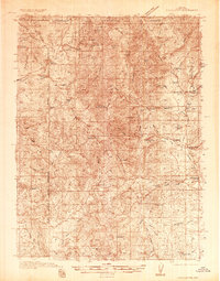
 1935 Lovelock1935 Print · USGSPershing County in the mid-1930s is a landscape of high-desert mining camps and essential rail hubs along the Humboldt. Researchers can trace the legacy of the silver and tungsten booms at Rochester, the Sulphur Mine, and the now-quiet streets of Unionville or Mazuma.3 unique versions available
 - 1935 Map of Halleck
 1935 Halleck1935 Print · USGSElko County cattle country and high mountain basins are captured here during the mid-thirties, showing the transition from frontier outposts to a ranching economy. Genealogists can trace family holdings like the Starr Ranch or locate the site of Fort Halleck and various rural schoolhouses.3 unique versions available
 - 1935 Map of Charleston
 1935 Charleston1935 Print · USGSElko County ranching and mining country comes alive in this mid-1930s survey of the high Nevada desert. Genealogists and historians can trace family homesteads like Mendive Ranch and Guerrricabita Ranch, or locate old operations such as Mc Knights Placer Mine.5 unique versions available
 - 1936 Map of Mountain City
 1936 Mountain City1936 Print · USGSElko County and the borderlands of Idaho are captured during the 1930s as mining and ranching shaped this high-desert region. Researchers can trace historic family properties like McKenzie Ranch or locate industrial sites such as the Rio Tinto Mine and the Allegheny Sch.4 unique versions available
 - 1936 Map of Rowland
 1936 Rowland1936 Print · USGSThe Nevada-Idaho borderlands come to life in the mid-1930s as a landscape of remote ranching and mining outposts. Trace the family legacies of the Hagenbuch Ranch and Palacio Ranch near the Bruneau Mine and Rowland PO.4 unique versions available
 - 1937 Map of Mineral Hill
 1937 Mineral Hill1937 Print · USGSEureka County mining and ranching operations are documented here in the late 1930s as the Eureka Nevada RR served the high desert. Researchers can trace historic family-named sites like Bruffey Ranch and the workings at the Old Whalen Mine.4 unique versions available
 - 1937 Map of Jiggs
 1937 Jiggs1937 Print · USGSElko County ranching life is preserved here during the 1930s, when isolated family homesteads were the primary anchors of the high desert landscape. Genealogists and historians can trace the locations of the Davis Ranch Hobson PO, the Smith Creek Sch, and the Harrison Pass Ranger Sta.2 unique versions available
 - 1938 Map of Cortez
 1938 Cortez1938 Print · USGSThe high-desert mining district of Lander and Eureka counties is captured here in the late 1930s. Researchers can locate remote mountain infrastructure like the Cortez Mine, Mill Canyon Sch, and several family-named outposts including Caetano Ranch.4 unique versions available
 - 1939 Map of Sonoma Range
 1939 Sonoma Range1939 Print · USGSHigh-desert ranching and deep-earth mining define this Nevada landscape during the late thirties. Researchers can trace historical family holdings like Seven Devils Ranch, early educational sites such as Pearce Sch, and industrial landmarks including the Copper Canyon Mine.5 unique versions available
 - 1939 Map of Eugene Mountains Area, 1958 Print
 1939 Eugene Mountains Area1958 Print · USGSPershing County's mining and transportation history are frozen in time just before the war as tungsten extraction peaked in the desert. Genealogists and historians can trace the Emigrant Trail and Old Stage Road alongside industrial landmarks like the Nevada Massachusetts Tungsten Mine and Mill City.3 unique versions available
 - 1939 Map of Owyhee, 1965 Print
 1939 Owyhee1965 Print · USGSThe Nevada-Idaho borderlands come into focus in the late 1930s, centered on the Duck Valley Indian Reservation and the vital Owyhee River. Researchers can trace early irrigation works like China Dam and find vanished points of interest such as Number One Settlement and the Idaho-Nev Shaft.
End of results
Showing maps 1-15
Top cities of Nevada
- Las Vegas historical maps
- Henderson historical maps
- Reno historical maps
- North Las Vegas historical maps
- Enterprise historical maps
- Spring Valley historical maps
See more
Top counties of Nevada
- Clark County historical maps
- Washoe County historical maps
- Carson City historical maps
- Lyon County historical maps
- Elko County historical maps
- Douglas County historical maps
See more
Frequently asked questions
- What are the different types of historical maps available for Nevada?
- What is the oldest map of Nevada?
- Where can I purchase historical maps of Nevada for my home or office?
- Where can I download high-res historical maps of Nevada?
- Are there historical topographic maps available for Nevada?
- Is there historical aerial imagery available for Nevada?
- Where are historical maps of Nevada sourced from?