Old Maps of Pittsburg, New Hampshire for Hiking & Exploration
Hike through history with 88 historic maps of Pittsburg. Explore old trails, ghost towns, and forgotten backroads — perfect for outdoor adventurers and local explorers.
- Rediscover forgotten places: Map out old mining camps, roads, and footpaths that no longer exist on modern maps.
- Layer with modern tools: Combine with LiDAR or satellite views to plan hikes through historical terrain.
- Made for exploration: Popular among hikers, overlanders, and local history lovers.
Use these maps to find adventure and explore the hidden past of Pittsburg.
Pittsburg, NH maps
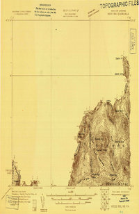
(88)- 1925 Map of Indian Stream
 1925 Indian Stream1925 Print · USGSThe northern tip of New Hampshire is captured here in the mid-1920s, showing a rugged territory of logging camps and border schools. Researchers can trace the lineage of remote settlements through Indian Stream School, Greeleys Camp, and the community at Happy Corner.
 - 1926 Map of Indian Stream
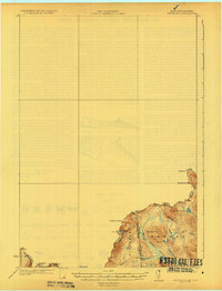
 1926 Indian Stream1926 Print · USGSUpper Coos County at the Canadian border comes alive in this survey of northern New Hampshire's timberlands and early settlements. Genealogists and historians can trace rural schoolhouses like Wheeler School and Indian Stream School, or locate old camps such as Happy Corner and Depot Camp.4 unique versions available
 - 1927 Map of Indian Stream
 1927 Indian Stream1927 Print · USGSThe northern reaches of Coos County are captured here in the mid-1920s, showing the remote borderlands between New Hampshire and Canada. Genealogists and historians can locate rural landmarks like the Clarksville Town Hall, the Wheeler School, and numerous timber camps like Varney Camp.5 unique versions available
 - 1927 Map of Moose Bog
 1927 Moose Bog1927 Print · USGSThe wilderness of the North Woods is charted in the late twenties along the border where Maine, New Hampshire, and Quebec meet. Researchers can trace the remote Bowman Farm and the high-elevation wetlands of Moose Bog and the Third East Branch Magalloway River.3 unique versions available
 - 1927 Map of Second Lake, 1955 Print
 1927 Second Lake1955 Print · USGSNorthern New Hampshire's high timberlands and the Connecticut River headwaters appear in the late twenties, spanning from the Canadian border down to the academy grants. Researchers can locate remote logging outposts like Depot Camp and Camp No 32 or trace the early shorelines of Second Lake and First Connecticut Lake.6 unique versions available
 - 1931 Map of Moose Bog
 1931 Moose Bog1931 Print · USGSThe Maine and New Hampshire borderlands are captured here in the early thirties, showing a remote wilderness of high peaks and river headwaters. Genealogists and historians can trace family-named landmarks like Bowman Farm, Bowman Hill, and the secluded waters of Moose Bog.5 unique versions available
 - 1932 Map of Second Lake
 1932 Second Lake1932 Print · USGSThe northern New Hampshire wilderness and Maine borderlands are captured here in the early 1930s, showing a landscape of logging camps and high peaks. Genealogists and historians can trace old sites like Idlewild, the Deer Mtn Fire Tower, and remote outposts such as Camp No 36.4 unique versions available
 - 1949 Map of Jackman
 1949 Jackman1949 Print · USGSThe Quebec and Maine borderlands are shown in great detail during the late 1940s, highlighting the industrial and natural geography of the region. Trace old rail lines like the Canadian Pacific and locate settlements from Sherbrooke to Scotstown.2 unique versions available
 - 1963 Map of Jackman
 1963 Jackman1963 Print · USGSThe international borderlands of Maine and Quebec come alive in the mid-twentieth century, showing a landscape of timber towns and rail connections. Genealogists and historians can trace the paths of the Canadian Pacific Railway through Jackman or locate families in Sherbrooke and Megantic.
 - 1966 Map of Sherbrooke
 1966 Sherbrooke1966 Print · USGSThe borderlands of Quebec and Maine come alive in the mid-1960s, documenting the industrial towns and deep woods of the Northeast. Genealogists can trace family lines through Sherbrooke and Coaticook, or locate remote logging outposts along the Moose River and Flagstaff Lake.
 - 1976 Map of Sherbrooke
 1976 Sherbrooke1976 Print · USGSThe northern Maine woods and Quebec’s Eastern Townships meet in this mid-century survey of the rugged international borderlands. Genealogists and historians can trace rail-and-river connections through Thetford Mines, follow the Dead River to Flagstaff Lake, or locate small border crossings at Stanhope and Beecher Falls.2 unique versions available
 - 1976 Map of Moose Bog, 1983 Print
 1976 Moose Bog1983 Print · USGSThe northern Maine wilderness near the Quebec border is seen here in the mid-1970s through detailed aerial orthophotography. Trace the remote waterways of the Magalloway River and identify secluded landmarks like Moose Bog and Barker Pond.
 - 1976 Map of Rump Mountain, 1983 Print
 1976 Rump Mountain1983 Print · USGSThe wilderness of the Maine-New Hampshire border is captured here in the mid-1970s through high-altitude aerial imagery. Trace the remote waters of Rump Pond and the high peaks of Rump Mountain and Prospect Mountain.
 - 1976 Map of Bosebuck Mountain, 1983 Print
 1976 Bosebuck Mountain1983 Print · USGSThe Maine-New Hampshire borderlands appear in striking photographic detail in the mid-seventies. Trace the rugged timberlands surrounding Aziscohos Lake and the remote course of the Little Magalloway River and Dead Diamond River.
 - 1986 Map of Sherbrooke
 1986 Sherbrooke1986 Print · USGSThe Great North Woods of the mid-eighties appear in detail across this survey of the New Hampshire and Canadian borderlands. Researchers can trace the entire chain of the First Connecticut Lake through the fourth, alongside remote settlements like Pittsburg and Beecher Falls.2 unique versions available
 - 1989 Map of Second Connecticut Lake
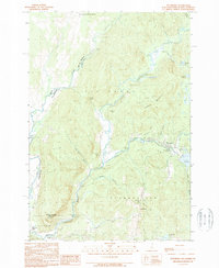
 1989 Second Connecticut Lake1989 Print · USGSThe high headwaters of the New Hampshire North Country are captured here in the late 1980s, tracing the river's path from the Canadian border. Researchers can locate the small settlement of Idlewild or follow the numerous timber-country drainages like Perry Stream and Moose Brook.
 - 1989 Map of Pittsburg
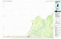
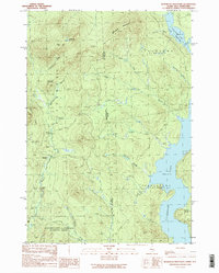
 1989 Pittsburg1989 Print · USGSNorthern New Hampshire's river-border country is captured here during the late eighties, showing the headwaters of the Connecticut River. Researchers can trace the varied terrain of Tabor Notch, the infrastructure of Lake Francis, and remote settlements like Pittsburg and Clarksville.3 unique versions available
 - 1989 Map of Bosebuck Mountain
 1989 Bosebuck Mountain1989 Print · USGSThe Maine-New Hampshire borderlands are captured here in the late 1980s, centered on the sprawling waters of Aziscohos Lake. Researchers can trace the remote logging landscape near Camp No 7, locate Garfield Falls, or follow the high ridges of Bosebuck Mountain.2 unique versions available
 - 1989 Map of Magalloway Mtn
 1989 Magalloway Mtn1989 Print · USGSCoos County, New Hampshire, is captured here in the late eighties, showing a wilderness of timber grants and high summits. You can trace the remote outposts at Camp Otter and Camp No 9 or follow the waters from Beaver Pond to the Dead Diamond River.
 - 1989 Map of Lake Francis
 1989 Lake Francis1989 Print · USGSUpper Coos County in the late 1980s reveals a landscape transitioning between timber management and forest recreation. Trace the sites of local landmarks like the Covered Bridge, the Cem at Happy Corner, and the expansive Lake Francis.
 - 1989 Map of Prospect Hill
 1989 Prospect Hill1989 Print · USGSThe international borderlands of northernmost New Hampshire and Quebec come into focus during the late eighties, where the Montagnes Blanches meet the Canadian line. Researchers can trace the cross-border settlements of Chartierville and Petit-Canada or locate family sites near Prospect Hill.
 - 1989 Map of Moose Bog
 1989 Moose Bog1989 Print · USGSThe northern reaches of the Maine-Quebec border come into focus in the late 1980s, showing a landscape of high peaks and river headwaters. Trace the historic Bowman Farm (Site) or locate remote landmarks like Mount D'Urban and the Magalloway River.
 - 1989 Map of Rump Mountain
 1989 Rump Mountain1989 Print · USGSThe Maine and New Hampshire borderlands come alive in this late twentieth-century survey of the high timberlands. Researchers can trace the rugged drainage of Parmachenee Lake and identify landmarks like Rump Mountain and Prospect Mountain.
 - 1989 Map of Cowen Hill
 1989 Cowen Hill1989 Print · USGSThe northern reaches of Pittsburg, New Hampshire, near the Quebec border are shown in the late eighties as a landscape of timber camps and wild waterways. Researchers can trace the locations of Depot Camp and Klondyke Camp along the banks of Indian Stream.
 - 1989 Map of Metallak Mountain
 1989 Metallak Mountain1989 Print · USGSThe international borderlands of New Hampshire and Quebec come into sharp focus in this late 1980s study of the Pittsburg area. Trace the winding course of Halls Stream and locate rural Canadian settlements like Saint-Malo and Malvina.
Showing maps 1-25 of 88
Top cities near Pittsburg
- Colebrook historical maps
- Stewartstown historical maps
- Canaan historical maps
- Clarksville historical maps
- Lincoln Plantation historical maps
- Dixville historical maps
See more
Top neighborhoods of Pittsburg
- The Glen historical maps
- Timberland historical maps
- Happy Corner historical maps
- Idlewilde historical maps
Frequently asked questions
- What are the different types of historical maps available for Pittsburg?
- What is the oldest map of Pittsburg?
- Where can I purchase historical maps of Pittsburg for my home or office?
- Where can I download high-res historical maps of Pittsburg?
- Are there historical topographic maps available for Pittsburg?
- Is there historical aerial imagery available for Pittsburg?
- Where are historical maps of Pittsburg sourced from?