1910s Maps of Colfax County, New Mexico
Explore 5 historic maps of Colfax County from the 1910s. These maps offer a rare glimpse into what life looked like during the 1910s — showing old roads, neighborhoods, homes, and landmarks that have changed or disappeared over time.
Whether you're researching your family's past, planning a metal detecting trip, or studying how Colfax County's landscape evolved across the 1910s, these high-resolution maps are a powerful tool for exploring the history of this region.
- Focus on a specific era: All maps on this page are from the 1910s, giving you a focused view of this time period.
- See what’s changed: Compare century-old streets, trails, and buildings to today's modern landscape using overlays and satellite layers.
- Research with precision: Use these maps for genealogy, historical research, land use analysis, or educational projects.
- View, download, or print: Maps are fully viewable online in high resolution, and can be downloaded or printed for your own records.
Start exploring Colfax County's history through authentic maps from the 1910s. This is your window into the past.
Colfax County, NM maps
(5)- 1912 Map of Raton, 1958 Print
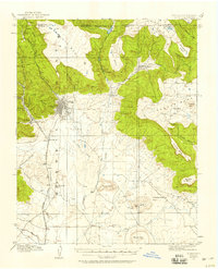 1912 Raton1958 Print · USGSRaton and the high mesas of the Colorado-New Mexico border are captured here just as the railroad era reached its peak. Researchers can trace the early industrial landscape of coal towns like Gardiner and Blossburg or locate the historic Clifton House and Raton Tunnel.2 unique versions available
 - 1914 Map of Raton
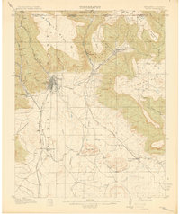 1914 Raton1914 Print · USGSRaton served as a vital mountain gateway during the early twentieth century as railroads and early highways crested the Colorado border. Researchers can trace the industrial spurs of the Wagon Mine or locate vanished stops like Blossburg, Gardiner, and Clifton House.5 unique versions available
 - 1915 Map of Brilliant
 1915 Brilliant1915 Print · USGSColfax County, New Mexico, was a hub of coal and rail activity in the years before the Great War. Researchers can trace the spur lines of the Atchison Topeka and Santa Fe into mining camps like Brilliant and Van Houten.3 unique versions available
 - 1915 Map of Koehler, 1966 Print
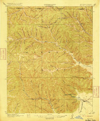
 1915 Koehler1966 Print · USGSColfax County at the height of its rail and ranching era reveals a landscape of massive land grants and early irrigation systems. Genealogists can trace family connections to ranching outposts like Crow Creek Ranch or early schools such as Red River School and Grand Valley School.
 - 1917 Map of Koehler
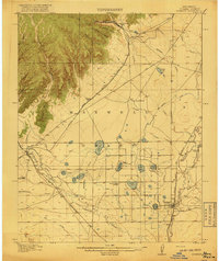 1917 Koehler1917 Print · USGSColfax County at the time of the Great War shows a transition from high desert canyons to a landscape transformed by large-scale ranching and irrigation. Genealogists and historians can trace the foundations of Maxwell, the cattle operations of C S Ranch, and early rural education at Red River School.2 unique versions available
End of results
Showing maps 1-5 of 5
Top cities of Colfax County
- Raton historical maps
- Angel Fire historical maps
- Springer historical maps
- Cimarron historical maps
- Eagle Nest historical maps
Frequently asked questions
- What are the different types of historical maps available for Colfax County?
- What is the oldest map of Colfax County?
- Where can I purchase historical maps of Colfax County for my home or office?
- Where can I download high-res historical maps of Colfax County?
- Are there historical topographic maps available for Colfax County?
- Is there historical aerial imagery available for Colfax County?
- Where are historical maps of Colfax County sourced from?