1980s Maps of Colfax County, New Mexico
Explore 26 historic maps of Colfax County from the 1980s. These maps offer a rare glimpse into what life looked like during the 1980s — showing old roads, neighborhoods, homes, and landmarks that have changed or disappeared over time.
Whether you're researching your family's past, planning a metal detecting trip, or studying how Colfax County's landscape evolved across the 1980s, these high-resolution maps are a powerful tool for exploring the history of this region.
- Focus on a specific era: All maps on this page are from the 1980s, giving you a focused view of this time period.
- See what’s changed: Compare century-old streets, trails, and buildings to today's modern landscape using overlays and satellite layers.
- Research with precision: Use these maps for genealogy, historical research, land use analysis, or educational projects.
- View, download, or print: Maps are fully viewable online in high resolution, and can be downloaded or printed for your own records.
Start exploring Colfax County's history through authentic maps from the 1980s. This is your window into the past.
Colfax County, NM maps
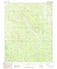
(26)- 1981 Map of Springer
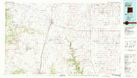 1981 Springer1981 Print · USGSNortheast New Mexico in the early eighties remains a landscape defined by its deep historical pathways and massive land grants. Genealogists and historians can trace the original Santa Fe Trail routes, the State Boys School at Springer, and the landmarks of Wagon Mound.
 - 1981 Map of Raton
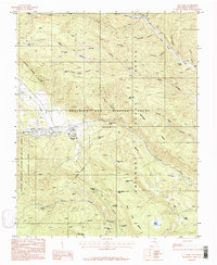
 1981 Raton1981 Print · USGSNorthern New Mexico's high mesas and mining corridors are preserved here as they appeared in the early eighties. Genealogists and historians can trace the transit networks of the Santa Fe Trail and find company towns like Van Houten and Koehler.
 - 1982 Map of Wheeler Peak, 1983 Print
 1982 Wheeler Peak1983 Print · USGSNorthern New Mexico in the early eighties shows a high-altitude landscape of historic mining camps and massive land grants. Researchers can trace the Old Railroad Grade near Elizabethtown or locate remote sites like the French-Henry Mine and Vermejo Park.
 - 1983 Map of Taos
 1983 Taos1983 Print · USGSNorthern New Mexico's high-country heritage is on full display in the early eighties, from the deep river canyons to the highest alpine peaks. Genealogists and historians can trace traditional land-grant settlements like Las Trampas, Truchas, and the historic Taos Pueblo.2 unique versions available
 - 1986 Map of Vermejo Park
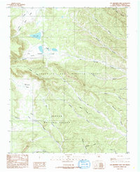
 1986 Vermejo Park1986 Print · USGSColfax County's high ranching country is shown here in the mid-1980s, shortly after extensive field checks and aerial revisions. Researchers can trace the sprawling boundaries of the Maxwell Grant, locate the Bartlett Mine, and find the small Cem near the Vermejo River.
 - 1986 Map of Van Bremmer Park
 1986 Van Bremmer Park1986 Print · USGSHigh-altitude canyons and historic land grants define this Colfax County terrain during the mid-eighties. Genealogists and researchers can trace local family-named landmarks like Whiteman Vega, Harry Bremmer Canyon, and the remote Graveyard Canyon.
 - 1986 Map of Casa Grande
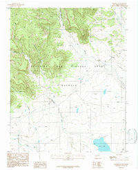
 1986 Casa Grande1986 Print · USGSColfax County in the mid-1980s reveals a high-country landscape shaped by the historic Maxwell Land Grant and deep-canyon coal mining. Researchers can trace the Old Railroad Grade and locate mining operations near Casa Grande and York Canyon.
 - 1986 Map of Caliente Canyon North
 1986 Caliente Canyon North1986 Print · USGSColfax County and the New Mexico-Colorado border are shown in the 1980s as the wilderness began reclaiming old industrial corridors. You can trace the Old Railroad Grade past the Catskill (Site) and find family-named landmarks like Ben Thompson Canyon.
 - 1986 Map of Caliente Canyon South
 1986 Caliente Canyon South1986 Print · USGSColfax County lands within the historic Maxwell Grant are shown here during the mid-1980s. Genealogists and historians can trace the naming of the rugged landscape through family-named landmarks like Ben Thompson Canyon and Mercer Canyon.
 - 1986 Map of Ash Mountain
 1986 Ash Mountain1986 Print · USGSNorthern New Mexico's high-country wilderness is captured here in the mid-1980s, detailing the intersection of Taos and Colfax counties. Hikers and historians can trace the paths near Little Costilla Peak, the drainage of Shuree Creek, and the massive The Rock Wall formation.
 - 1986 Map of Casa Grande SW
 1986 Casa Grande SW1986 Print · USGSColfax County in the mid-1980s is captured here within the historic bounds of the Beaubien and Miranda (Maxwell) Grant. Genealogists and historians can trace the complex geography of the Vermejo River and family-named landmarks like Juan Baca Canyon and Valdez Canyon.
 - 1986 Map of The Wall
 1986 The Wall1986 Print · USGSThe Sangre de Cristo high country on the Colorado-New Mexico border is captured here in the mid-1980s, documenting the remote land grants and watersheds of Colfax County. Researchers can trace historic mining and land use through the Van Lint Mine, a lone Cemetery, and high-altitude water sources like Underwood Lakes and Bernal Lake.
 - 1987 Map of House Canyon
 1987 House Canyon1987 Print · USGSColfax County in the late 1980s was a landscape of massive land grants and remote wilderness camps. You can trace the Philmont Scout Ranch Boundary across the terrain, locating isolated features like the Grave and Cottonwood Trail Camp.
 - 1987 Map of Ute Park
 1987 Ute Park1987 Print · USGSColfax County in the late eighties serves as a premier destination for wilderness adventure and land grant history. Researchers and scouts can trace the network of backcountry outposts like Black Jacks Camp, the Ute Gulch Commissary, and the settlement at Ute Park.
 - 1987 Map of Agua Fria Peak
 1987 Agua Fria Peak1987 Print · USGSHigh-altitude ranchlands and scout territories meet in the late 1980s along the Colfax and Mora county line. Researchers can trace the varied terrain of the Philmont Scout Ranch or locate landmarks like Agua Fria Peak and Hidden Lake.
 - 1987 Map of Cimarron SE
 1987 Cimarron SE1987 Print · USGSColfax County, New Mexico, is shown here in the late eighties, dominated by the legacy of the huge Beaubien and Miranda Grant (Maxwell). Researchers can trace historic transit paths including the Santa Fe Trail and an Old Railroad Grade near the Vermejo River.
 - 1987 Map of Baldy Mountain
 1987 Baldy Mountain1987 Print · USGSThe high peaks and mining history of Colfax County are preserved here in the late eighties. Researchers can locate remote outposts like French Henry Camp, the historic Aztec Mine, and the sprawling boundaries of the Philmont Scout Ranch.2 unique versions available
 - 1987 Map of Coyote Mesa
 1987 Coyote Mesa1987 Print · USGSColfax County's high-country terrain is captured in the late 1980s, showcasing the extensive geography of the Philmont Scout Ranch. Researchers can trace old mountain outposts like Zastrow Camp and Nairn Place or locate landmarks such as Tooth of Time Ridge.
 - 1987 Map of Miami NE
 1987 Miami NE1987 Print · USGSNortheastern New Mexico in the late eighties remains a land of massive historical grants and early western transit routes. Researchers can trace the legendary SANTA FE TRAIL as it crosses the Beaubien and Miranda Grant near C S Ranch and the Cimarron River.
 - 1987 Map of Touch-Me-Not Mountain
 1987 Touch-Me-Not Mountain1987 Print · USGSThe high Sangre de Cristo foothills of Colfax County appear in the late eighties as a landscape of scouting tradition and mining history. Trace the trails between Philmont Scout Ranch outposts like Ewells Park Camp or locate the site of Virginia City and the Horseshoe Mine.
 - 1987 Map of Dawson
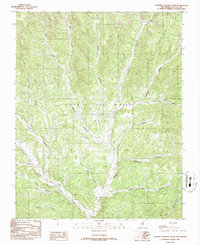
 1987 Dawson1987 Print · USGSIn the canyon-riven country of Colfax County during the 1980s, the settlement of Dawson sits along the winding Vermejo River. Researchers can trace the path of the Atchison Topeka and Santa Fe railroad or locate local landmarks like the Cem and Capitan Hill.
 - 1987 Map of White Peak
 1987 White Peak1987 Print · USGSColfax and Mora counties in the late 1980s showcase a high-elevation landscape of historic land grants and ranching outposts. Researchers can trace the ranching economy through sites like Mora Ranch, La Grulla Cow Camp, and the White Peak Lookout Tower.
 - 1987 Map of Rayado
 1987 Rayado1987 Print · USGSColfax County ranching and scout history are well-preserved in this 1980s survey of the high mesas and historic trails. Researchers can trace the path of the Santa Fe Trail and locate sites like Rayado Camp, Sunny Side, and the local Cem.
 - 1987 Map of Abreu Canyon
 1987 Abreu Canyon1987 Print · USGSColfax County's canyon country in the 1980s served as a premier wilderness landscape for scouting and wildlife management. Researchers can trace the backcountry outposts of the Philmont Scout Ranch such as Dan Beard Camp and Old Camp along Ponil Creek.
 - 1987 Map of Miami
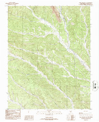
 1987 Miami1987 Print · USGSColfax County's high mesa country is captured here in the late eighties, showing the intersection of historic land grants and ranching life. Genealogists and historians can locate the Cem near Miami, trace the Abandoned Canal, and find old sites like Salado and Alona.
Showing maps 1-25 of 26
Top cities of Colfax County
- Raton historical maps
- Angel Fire historical maps
- Springer historical maps
- Cimarron historical maps
- Eagle Nest historical maps
Frequently asked questions
- What are the different types of historical maps available for Colfax County?
- What is the oldest map of Colfax County?
- Where can I purchase historical maps of Colfax County for my home or office?
- Where can I download high-res historical maps of Colfax County?
- Are there historical topographic maps available for Colfax County?
- Is there historical aerial imagery available for Colfax County?
- Where are historical maps of Colfax County sourced from?