1990s Maps of Colfax County, New Mexico
Explore 18 historic maps of Colfax County from the 1990s. These maps offer a rare glimpse into what life looked like during the 1990s — showing old roads, neighborhoods, homes, and landmarks that have changed or disappeared over time.
Whether you're researching your family's past, planning a metal detecting trip, or studying how Colfax County's landscape evolved across the 1990s, these high-resolution maps are a powerful tool for exploring the history of this region.
- Focus on a specific era: All maps on this page are from the 1990s, giving you a focused view of this time period.
- See what’s changed: Compare century-old streets, trails, and buildings to today's modern landscape using overlays and satellite layers.
- Research with precision: Use these maps for genealogy, historical research, land use analysis, or educational projects.
- View, download, or print: Maps are fully viewable online in high resolution, and can be downloaded or printed for your own records.
Start exploring Colfax County's history through authentic maps from the 1990s. This is your window into the past.
Colfax County, NM maps
(18)- 1994 Map of Tooth Of Time, 1998 Print
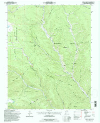
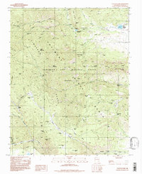 1994 Tooth Of Time1998 Print · USGSThe Sangre de Cristo high country is captured here during the mid-1990s, centered on the historic mountain camps of the Philmont Ranch. Trace the trails connecting the iconic Tooth of Time to remote outposts like Cyphers Mine Camp and Beaubien Camp.
 - 1994 Map of Garcia Peak, 1998 Print
 1994 Garcia Peak1998 Print · USGSHigh in the Cimarron Range during the 1990s, this area shows the intersection of famous scouting lands and historic land grants. Trace the locations of back-country outposts like Crooked Creek Camp, the Angel Fire Ski Area, and the southern reaches of the Philmont Scout Ranch.
 - 1994 Map of Agua Fria Peak, 1998 Print
 1994 Agua Fria Peak1998 Print · USGSHigh-altitude New Mexico territory in the mid-1990s showcases a rugged landscape of ridges and ranch lands. Researchers can trace the bounds of the Philmont Scout Ranch and historic land grants near Agua Fria Peak and Hidden Lake.
 - 1994 Map of White Peak, 1998 Print
 1994 White Peak1998 Print · USGSColfax and Mora counties come together at this high mountain junction during the mid-nineties, where the Philmont Scout Ranch dominates the landscape. Genealogists and researchers can trace old ranching outposts like La Grulla Cow Camp and landmarks such as the White Peak Lookout Tower.
 - 1995 Map of Red River Pass, 1997 Print
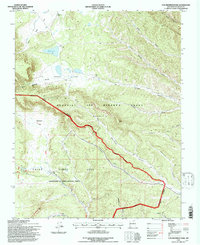
 1995 Red River Pass1997 Print · USGSThe Sangre de Cristo Mountains in the mid-1990s showcase a high-alpine landscape of historic land grants and wilderness. Researchers can trace early settlements at Memphis, locate high-country crossings like Bobcat Pass, and find old ranching sites including Moreno Ranch.
 - 1995 Map of Van Bremmer Park, 1997 Print
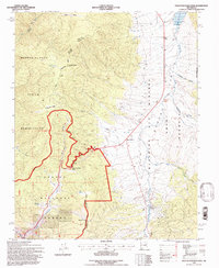
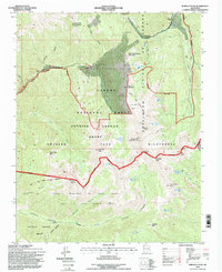
 1995 Van Bremmer Park1997 Print · USGSColfax County's high parklands are captured here in the 1990s as the landscape transitioned between historic private grants and federal forest management. Researchers can locate remote landmarks like the Cemetery and trace the complex boundaries of the Beaubien and Miranda Grant (Maxwell).
 - 1995 Map of Eagle Nest, 1997 Print
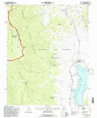 1995 Eagle Nest1997 Print · USGSThe Moreno Valley comes into focus during the mid-nineties, showing the intersection of historic land grants and high-country wilderness. Trace the remnants of the gold-mining era at Elizabethtown or the Klondike Mine while exploring the shores of Eagle Nest Lake.
 - 1995 Map of Osha Mountain, 1997 Print
 1995 Osha Mountain1997 Print · USGSThe high peaks and land grants of northern New Mexico are captured here in the mid-1990s as the borders of three counties meet. Genealogists and local historians can trace legacy sites like the San Antonio Ch Cem or navigate the high reaches of Osha Mountain and Valle Largo.
 - 1995 Map of Palo Flechado Pass, 1997 Print
 1995 Palo Flechado Pass1997 Print · USGSHigh-altitude mountain passes and historical land grants define this corner of the Sangre de Cristo range in the mid-1990s. Researchers can trace the borders of the Pueblo de Taos Indian Reservation or locate the Angel Fire Ski Area and Agua Fria.2 unique versions available
 - 1995 Map of The Wall, 1997 Print
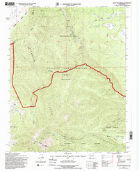
 1995 The Wall1997 Print · USGSNorthern New Mexico and the Colorado borderland are shown in the mid-nineties, featuring the intersection of historic land grants and national forest. Researchers can trace remote mountain outposts like Bernal Cabin, the Van Diest Mine, and landmarks like Vermejo Peak.
 - 1995 Map of Abreu Canyon, 1997 Print
 1995 Abreu Canyon1997 Print · USGSNorthern New Mexico's high canyons and wildlife areas were carefully documented in the mid-nineties as land management evolved. Researchers can trace the rugged boundaries of the Philmont Scout Ranch and the historical Beaubien and Miranda Grant near Wilson Mesa.
 - 1995 Map of Ash Mountain, 1998 Print
 1995 Ash Mountain1998 Print · USGSThe high Sangre de Cristo Mountains of northern New Mexico are documented here in the mid-1990s as federal management expanded across old land grants. Researchers can locate the historic Mc Crystal Place, the small settlement at Shuree, and family-named landmarks like Harry Bremmer Canyon.
 - 1995 Map of Wheeler Peak, 1998 Print
 1995 Wheeler Peak1998 Print · USGSThe high Sangre de Cristo range reaches its summit in the mid-1990s as alpine recreation and ancient land grants intersect. Researchers can trace the sprawling boundaries of the Taos Pueblo Grant and locate early mining sites like the Bull-of-the-Woods Mines near Twining.
 - 1995 Map of Baldy Mountain, 1998 Print
 1995 Baldy Mountain1998 Print · USGSColfax County's high-country terrain is captured in the mid-1990s, revealing the complex borders of massive land grants and scout territories. Researchers can trace historic mining operations at the Aztec Mine or locate landmarks like Mills Divide and Beatty Lakes.
 - 1998 Map of Divine Lake, 2001 Print
 1998 Divine Lake2001 Print · USGSNortheastern New Mexico's high plateau country is recorded here in the late nineties where Colfax and Harding counties meet. Genealogists and researchers can trace local landmarks like Mofax Cem, the Sugarloaf Ranch, and numerous family-named sites such as Sanders East Well.
 - 1998 Map of Jaritas Ranch, 2001 Print
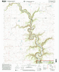 1998 Jaritas Ranch2001 Print · USGSThe high plains of Mora County met the deep breaks of the Canadian River at the end of the twentieth century. Genealogists and historians can trace family land ties near Jaritas Ranch or explore the drainage networks of Dog Canyon and Lodge Canyon.
 - 1998 Map of Abbott Lake, 2001 Print
 1998 Abbott Lake2001 Print · USGSThe high plains of Harding and Colfax counties are captured here in the late twentieth century as cattle ranching and grassland conservation define the land. Genealogists can locate family landmarks like Johnson Cem, Johnson Ranch, and Case Ranch along the banks of Sauz Creek.
 - 1998 Map of Spear Hills, 2001 Print
 1998 Spear Hills2001 Print · USGSNortheastern New Mexico rangelands are documented here during the late nineties, showing the managed terrain of the Kiowa National Grassland. Researchers can trace the essential water network of the high plains through named landmarks like Franks Place Well, Chateau Hill, and Carrizo Creek.
End of results
Showing maps 1-18 of 18
Top cities of Colfax County
- Raton historical maps
- Angel Fire historical maps
- Springer historical maps
- Cimarron historical maps
- Eagle Nest historical maps
Frequently asked questions
- What are the different types of historical maps available for Colfax County?
- What is the oldest map of Colfax County?
- Where can I purchase historical maps of Colfax County for my home or office?
- Where can I download high-res historical maps of Colfax County?
- Are there historical topographic maps available for Colfax County?
- Is there historical aerial imagery available for Colfax County?
- Where are historical maps of Colfax County sourced from?