1930s Maps of Sandoval County, New Mexico
Explore 6 historic maps of Sandoval County from the 1930s. These maps offer a rare glimpse into what life looked like during the 1930s — showing old roads, neighborhoods, homes, and landmarks that have changed or disappeared over time.
Whether you're researching your family's past, planning a metal detecting trip, or studying how Sandoval County's landscape evolved across the 1930s, these high-resolution maps are a powerful tool for exploring the history of this region.
- Focus on a specific era: All maps on this page are from the 1930s, giving you a focused view of this time period.
- See what’s changed: Compare century-old streets, trails, and buildings to today's modern landscape using overlays and satellite layers.
- Research with precision: Use these maps for genealogy, historical research, land use analysis, or educational projects.
- View, download, or print: Maps are fully viewable online in high resolution, and can be downloaded or printed for your own records.
Start exploring Sandoval County's history through authentic maps from the 1930s. This is your window into the past.
Sandoval County, NM maps
(6)- 1934 Map of Alameda
 1934 Alameda1934 Print · USGSThe Rio Grande valley in the mid-1930s reveals a landscape of deep-rooted land grants and modernizing infrastructure. Genealogists and historians can trace the irrigation ditches around Alameda and find landmarks like the Nazareth Sanatorium and KOB Radio Transmitter.
 - 1934 Map of Griegos
 1934 Griegos1934 Print · USGSThe Rio Grande valley north of Albuquerque is shown here in the mid-thirties as a landscape of historic land grants and complex irrigation. Genealogists and historians can trace the early rail-and-road network near Hahn Station and the Alameda Bridge.
 - 1937 Map of Jemez Springs
 1937 Jemez Springs1937 Print · USGSThe Jemez Mountains in the late thirties were a landscape of geothermal activity and sprawling land grants. Researchers can trace historic family outposts like Boyd Ranch and Ruiz Ranch or locate New Deal-era sites such as the CCC Camp.
 - 1938 Map of Albuquerque
 1938 Albuquerque1938 Print · USGSAlbuquerque and the Rio Grande Valley are shown in the late 1930s, when irrigation ditches still defined the rural landscape between the river and the mountains. Researchers can trace ancestral lands through the Town of Atrisco Grant or locate landmarks like the U S Indian School and Old Albuquerque.
 - 1939 Map of La Ventana, 1957 Print
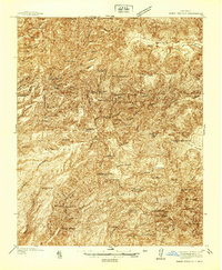
 1939 La Ventana1957 Print · USGSSandoval County at the end of the Depression era shows a landscape where high-desert ranching meets mountain timber and mining. Genealogists and historians can trace old homesteads and work sites like Señorita, the Luciani Mines, and the Ojitos Logging Camp.2 unique versions available
 - 1939 Map of San Ysidro, 1958 Print
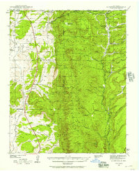
 1939 San Ysidro1958 Print · USGSCentral New Mexico in the late 1930s is revealed here as a land of sprawling Indian Reservations and high-desert ranching. Genealogists and historians can trace family locations at Rincon Ranch, locate the CCC Camp No 8 N, or follow the Santa Fe Northwestern rail line.
End of results
Showing maps 1-6 of 6
Top cities of Sandoval County
- Rio Rancho historical maps
- Bernalillo historical maps
- Corrales historical maps
- Cuba historical maps
- Peña Blanca historical maps
- Jemez Springs historical maps
See more
Frequently asked questions
- What are the different types of historical maps available for Sandoval County?
- What is the oldest map of Sandoval County?
- Where can I purchase historical maps of Sandoval County for my home or office?
- Where can I download high-res historical maps of Sandoval County?
- Are there historical topographic maps available for Sandoval County?
- Is there historical aerial imagery available for Sandoval County?
- Where are historical maps of Sandoval County sourced from?