1940s Maps of Sandoval County, New Mexico
Explore 6 historic maps of Sandoval County from the 1940s. These maps offer a rare glimpse into what life looked like during the 1940s — showing old roads, neighborhoods, homes, and landmarks that have changed or disappeared over time.
Whether you're researching your family's past, planning a metal detecting trip, or studying how Sandoval County's landscape evolved across the 1940s, these high-resolution maps are a powerful tool for exploring the history of this region.
- Focus on a specific era: All maps on this page are from the 1940s, giving you a focused view of this time period.
- See what’s changed: Compare century-old streets, trails, and buildings to today's modern landscape using overlays and satellite layers.
- Research with precision: Use these maps for genealogy, historical research, land use analysis, or educational projects.
- View, download, or print: Maps are fully viewable online in high resolution, and can be downloaded or printed for your own records.
Start exploring Sandoval County's history through authentic maps from the 1940s. This is your window into the past.
Sandoval County, NM maps
(6)- 1940 Map of Cuba, 1962 Print
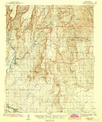
 1940 Cuba1962 Print · USGSNorthwestern New Mexico’s high country is captured here just before the mid-century, where the Santa Fe National Forest meets early ranching outposts. Researchers can trace ancestral locations at the Gallina Cem, Capulin Sch, and remote sites like Old Mestas Ranch.2 unique versions available
 - 1943 Map of San Ysidro
 1943 San Ysidro1943 Print · USGSSandoval County in the late 1930s is a landscape of high-altitude ranching and rugged mountain passes just as the local rail industry began to fade. Researchers can trace the Santa Fe Northwestern rail grade or locate remote outposts like CCC Camp No 8 N and Marquez Ranch.
 - 1943 Map of Jemez
 1943 Jemez1943 Print · USGSSandoval County at the end of the 1930s shows a landscape of expansive pueblo grants and former rail corridors. You can trace the Santa Fe Northwestern (RR Abandoned) line and locate the Paliza C C C Camp and Spanish Queen Mine.4 unique versions available
 - 1943 Map of Cuba
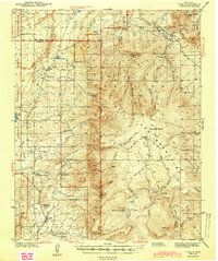 1943 Cuba1943 Print · USGSIn the Sandoval County high country during the early 1940s, ranching outposts and small mountain settlements were the heart of the community. You can trace the locations of historic rural education sites like La Jara Sch and find family landmarks such as Old Meatas Ranch and Vallecito Damian.2 unique versions available
 - 1943 Map of La Ventana
 1943 La Ventana1943 Print · USGSSandoval County during the early 1940s was a landscape defined by high mountain forests and scattered mining outposts. Researchers can trace the legacy of timber and coal through the Ojitos Logging Camp, Luciani Mines, and old schools like Copper City Sch.2 unique versions available
 - 1944 Map of Jemez Springs
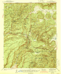 1944 Jemez Springs1944 Print · USGSThe Jemez Mountains and Sandoval County hinterlands in the late thirties show a rugged landscape of geothermal springs and Civilian Conservation Corps projects. Researchers can trace historic family holdings like Martinez Ranch or visit the Battleship Rock CCC Camp and Sulphur Springs.3 unique versions available
End of results
Showing maps 1-6 of 6
Top cities of Sandoval County
- Rio Rancho historical maps
- Bernalillo historical maps
- Corrales historical maps
- Cuba historical maps
- Peña Blanca historical maps
- Jemez Springs historical maps
See more
Frequently asked questions
- What are the different types of historical maps available for Sandoval County?
- What is the oldest map of Sandoval County?
- Where can I purchase historical maps of Sandoval County for my home or office?
- Where can I download high-res historical maps of Sandoval County?
- Are there historical topographic maps available for Sandoval County?
- Is there historical aerial imagery available for Sandoval County?
- Where are historical maps of Sandoval County sourced from?