1990s Maps of Sandoval County, New Mexico
Explore 23 historic maps of Sandoval County from the 1990s. These maps offer a rare glimpse into what life looked like during the 1990s — showing old roads, neighborhoods, homes, and landmarks that have changed or disappeared over time.
Whether you're researching your family's past, planning a metal detecting trip, or studying how Sandoval County's landscape evolved across the 1990s, these high-resolution maps are a powerful tool for exploring the history of this region.
- Focus on a specific era: All maps on this page are from the 1990s, giving you a focused view of this time period.
- See what’s changed: Compare century-old streets, trails, and buildings to today's modern landscape using overlays and satellite layers.
- Research with precision: Use these maps for genealogy, historical research, land use analysis, or educational projects.
- View, download, or print: Maps are fully viewable online in high resolution, and can be downloaded or printed for your own records.
Start exploring Sandoval County's history through authentic maps from the 1990s. This is your window into the past.
Sandoval County, NM maps
(23)- 1990 Map of Madrid
 1990 Madrid1990 Print · USGSAt the close of the twentieth century, this Santa Fe County landscape shows a region shaped by mining and rail. Genealogists and historians can trace the Madrid Cem and old transportation routes like the Old Railroad Grade near Cerrillos.
 - 1990 Map of Golden
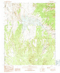
 1990 Golden1990 Print · USGSSanta Fe County mining history is preserved on this 1990 map of the Ortiz and San Pedro Mountains. Genealogists and historians can trace the foundations of Golden, locate the Old Ortiz Mine, and find the remote Boxcar Camp and Cem.2 unique versions available
 - 1990 Map of Los Griegos, 1996 Print
 1990 Los Griegos1996 Print · USGSThe Middle Rio Grande Valley in the early nineties shows a landscape of rapid suburban expansion meeting ancient heritage. Researchers can trace historic landmarks like Los Poblanos Ranch and the cultural sites of Petroglyph National Monument.
 - 1990 Map of The Volcanoes, 1996 Print
 1990 The Volcanoes1996 Print · USGSThe West Mesa of Albuquerque comes into focus during the 1990s, showcasing the distinct cinder cones and ancient land grants of the high desert. Researchers can trace the volcanic chain from Vulcan Volcano to J A Volcano and locate early 20th-century remnants like Black Ranch.
 - 1990 Map of Sandia Park, 1996 Print
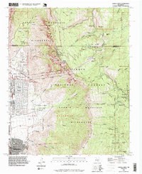
 1990 Sandia Park1996 Print · USGSThe East Mountains of New Mexico come into sharp focus in the 1990s, revealing a landscape where ancestral sites and pioneer routes meet growing mountain communities. Trace historic transit lines like the Old Stagecoach Road or locate the Pa-ako Ruins and La Madera Cemetery.
 - 1990 Map of Santa Ana Pueblo, 1996 Print
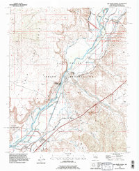
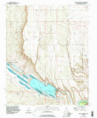 1990 Santa Ana Pueblo1996 Print · USGSSanta Ana Pueblo and the surrounding tribal lands are captured in the 1990s as the Jemez River flows through the high desert. Researchers can trace the path of the Old Railroad Grade and locate features like the Jemez Canyon Dam Spillway and Mesa Santa Rosa De Cubero.
 - 1990 Map of San Felipe Pueblo NE, 1996 Print
 1990 San Felipe Pueblo NE1996 Print · USGSTribal lands in Sandoval County are meticulously detailed during the early nineties, centered on the Santo Domingo Indian Reservation. Local history researchers can trace the course of Galisteo Creek and locate the Santo Domingo School and scattered Prospects.
 - 1990 Map of San Pedro, 1996 Print
 1990 San Pedro1996 Print · USGSThe Santa Fe and Bernalillo county line runs through this rugged mining and ranching district during the late twentieth century. Researchers can trace the Old Stagecoach Road, locate family burials at San Pedro Cemetery, and find legacy sites like Cedar Grove.
 - 1990 Map of Benavidez Ranch, 1996 Print
 1990 Benavidez Ranch1996 Print · USGSBernalillo and Sandoval counties are captured in the early 1990s, showcasing a landscape of tribal lands and traditional cattle operations. Researchers can trace the river's path past Rio Puerco Ranch, Benavidez Ranch, and the Town of Atrisco.
 - 1990 Map of Arroyo De Las Calabacillas, 1996 Print
 1990 Arroyo De Las Calabacillas1996 Print · USGSSandoval County during the early nineties shows the desert landscape north of Albuquerque as modern infrastructure met historic land grants. Trace the Grant Boundary and the winding Arroyo de las Calabacillas near the rising community of Rio Rancho.
 - 1990 Map of San Felipe Mesa, 1996 Print
 1990 San Felipe Mesa1996 Print · USGSThe high desert of Sandoval County is mapped here in the late twentieth century, showing the intersection of ranching life and tribal lands. Researchers can trace the San Francisco (Ruins) and remote outposts like Ojito Ranch and Navajo Windmill.
 - 1990 Map of Bernalillo, 1996 Print
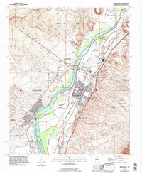 1990 Bernalillo1996 Print · USGSBernalillo and the Rio Grande valley are captured here in the early nineties during a period of suburban expansion alongside ancient pueblo lands. Trace irrigation history through the Bernalillo No 1 Lateral and find local landmarks like Carroll Sch or Sandia Pueblo.
 - 1990 Map of Sandia Crest, 1996 Print
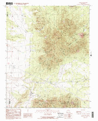
 1990 Sandia Crest1996 Print · USGSThe high peaks of the Sandia Mountains and the expanding edge of Albuquerque meet here in the 1990s. Trace local history through landmarks like the Cañoncito Cemetery, the La Luz Mine, and the Sandia Peak Ski Area.2 unique versions available
 - 1990 Map of Loma Machete, 1996 Print
 1990 Loma Machete1996 Print · USGSSandoval County during a period of rapid suburban expansion shows the desert landscape being reshaped by new residential development. Trace the early street grids of Rio Rancho and Corrales alongside topographic landmarks like Picuda Peak and the Santa Ana Indian Reservation.
 - 1990 Map of Hagan, 1996 Print
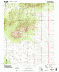
 1990 Hagan1996 Print · USGSSandoval County's high desert is captured here in the 1990s, revealing a landscape of ancient sites and early industrial remnants. Local historians can trace the Old RR Grade and locate historical settlements like Hagan, Tejon, and the Tonque Pueblo (Site).
 - 1990 Map of Bernalillo NW, 1996 Print
 1990 Bernalillo NW1996 Print · USGSTribal lands in Sandoval County are captured here in the 1990s as the high desert landscape meets the Jemez River. Researchers can trace the path of an Old Railroad Grade and locate water landmarks like the Jemez Windmill.
 - 1990 Map of San Felipe Pueblo, 1996 Print
 1990 San Felipe Pueblo1996 Print · USGSThe Rio Grande valley in the early nineties reveals a complex landscape of traditional pueblo lands and modern irrigation. Trace the intricate canal networks near San Felipe Pueblo and locate landmarks like the Algodones Sch and Algodones Power Plant.
 - 1990 Map of Alameda, 1998 Print
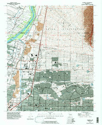 1990 Alameda1998 Print · USGSThe northern edge of the Albuquerque metro area and the Sandia Pueblo are captured here in the early nineties as suburban growth reached the river. Local historians can trace the irrigation systems like the Corrales Main Canal and find landmarks like Balloon Fiesta Park and Coronado Airport.
 - 1990 Map of Placitas, 1998 Print
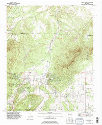
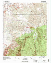 1990 Placitas1998 Print · USGSThe Sandoval County foothills and the Sandia Mountains are captured here in the 1990s as modern boundaries met ancient lands. Researchers can trace the Atchison Topeka and Santa Fe rail line or locate ancestral sites like Sandia Man Cave and Algodones Cem.
 - 1995 Map of Guadalupe, 1997 Print
 1995 Guadalupe1997 Print · USGSGuadalupe and the surrounding land grants are shown in detail as they appeared in the mid-1990s. Researchers can trace the path of the Rio Puerco and locate historical landmarks like the Guadalupe Cemetery and the Ignacio Chavez Grant.
 - 1995 Map of Cerro Tinaja, 1998 Print
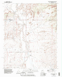
 1995 Cerro Tinaja1998 Print · USGSThe Sandoval County high desert in the mid-1990s reveals a landscape of massive land grants and remote ranching life. Genealogists and researchers can trace family-named landmarks like Sanchez Ranch and historic water sources such as Juan Chullo Well.
 - 1995 Map of Cerro Parido, 1998 Print
 1995 Cerro Parido1998 Print · USGSNorthwestern New Mexico ranching country remains centered on isolated outposts and high mesas in the late twentieth century. Genealogists can trace family holdings at Sandoval Ranch and Joe Montoya Ranch or locate landmarks like Cerro Parido.
 - 1995 Map of Laguna Seca, 1998 Print
 1995 Laguna Seca1998 Print · USGSHigh-plateau ranching and wildlife lands in McKinley and Sandoval counties are captured here during the mid-nineties. Trace the boundaries of the Nuestra Señora de la Luz de las Lagunitas Grant and find vital water sources like Ojo Frio and Laguna Seca.
End of results
Showing maps 1-23 of 23
Top cities of Sandoval County
- Rio Rancho historical maps
- Bernalillo historical maps
- Corrales historical maps
- Cuba historical maps
- Peña Blanca historical maps
- Jemez Springs historical maps
See more
Frequently asked questions
- What are the different types of historical maps available for Sandoval County?
- What is the oldest map of Sandoval County?
- Where can I purchase historical maps of Sandoval County for my home or office?
- Where can I download high-res historical maps of Sandoval County?
- Are there historical topographic maps available for Sandoval County?
- Is there historical aerial imagery available for Sandoval County?
- Where are historical maps of Sandoval County sourced from?