1940s Maps of Socorro County, New Mexico
Explore 11 historic maps of Socorro County from the 1940s. These maps offer a rare glimpse into what life looked like during the 1940s — showing old roads, neighborhoods, homes, and landmarks that have changed or disappeared over time.
Whether you're researching your family's past, planning a metal detecting trip, or studying how Socorro County's landscape evolved across the 1940s, these high-resolution maps are a powerful tool for exploring the history of this region.
- Focus on a specific era: All maps on this page are from the 1940s, giving you a focused view of this time period.
- See what’s changed: Compare century-old streets, trails, and buildings to today's modern landscape using overlays and satellite layers.
- Research with precision: Use these maps for genealogy, historical research, land use analysis, or educational projects.
- View, download, or print: Maps are fully viewable online in high resolution, and can be downloaded or printed for your own records.
Start exploring Socorro County's history through authentic maps from the 1940s. This is your window into the past.
Socorro County, NM maps
(11)- 1947 Map of Capitol Peak, 1955 Print
 1947 Capitol Peak1955 Print · USGSThe northern reaches of the San Andres Mountains appear at the dawn of the atomic age, as the White Sands Proving Ground was being established. Researchers can trace remote water sources like Malpais Spring and the complex terrain of the Lava Bed and Mockingbird Gap.
 - 1948 Map of Carthage, 1954 Print
 1948 Carthage1954 Print · USGSCarthage and Tokay were at the center of Socorro County's coal and ranching country in the late 1940s. Genealogists and historians can trace family ranch sites like Muncy Ranch or locate the historic Hart Coal Mine and Gilmore Coal Mine.
 - 1948 Map of Broken Back Crater, 1954 Print
 1948 Broken Back Crater1954 Print · USGSThe Socorro County desert meets mid-century military history in the late 1940s. Genealogists and historians can trace ranching life at Harvey Ranch Headquarters or find early military markers within the White Sands Proving Ground.2 unique versions available
 - 1948 Map of Granjean Well, 1954 Print
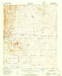
 1948 Granjean Well1954 Print · USGSSocorro County during the late 1940s reflects a landscape at the crossroads of traditional ranching and the atomic age. Genealogists and historians can locate established holdings like McDonald Ranch Headquarters and Story Ranch as they were being absorbed into the White Sands Proving Ground.
 - 1948 Map of Bingham, 1954 Print
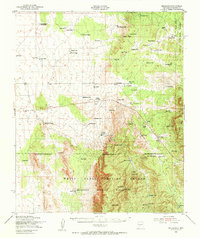 1948 Bingham1954 Print · USGSRanching life and mining ventures met the dawn of the atomic age in central New Mexico during the late 1940s. Genealogists can trace family holdings like the Coker Headquarters or B Lucero Ranch alongside local landmarks like the White Store and Royal Flush Mine.
 - 1948 Map of Chihuahua Ranch, 1954 Print
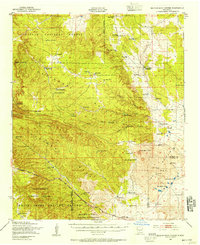
 1948 Chihuahua Ranch1954 Print · USGSLincoln County was a center for military testing and cattle ranching in the late 1940s. Genealogists and researchers can trace family-named sites like Barnes Ranch and Withers Ranch alongside the Oscura Coal Mine (Abandoned).
 - 1948 Map of San Antonio, 1954 Print
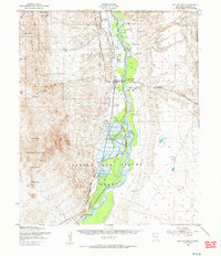 1948 San Antonio1954 Print · USGSThe Rio Grande valley in the years following the war reveals a landscape of railroad towns and vast migratory bird habitats. Genealogists and historians can trace family landholdings from Jacobo Sedillo Ranch to San Antonio, alongside the Atchison Topeka and Santa Fe rail line.2 unique versions available
 - 1948 Map of Val Verde, 1954 Print
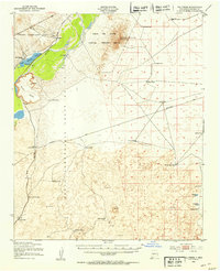 1948 Val Verde1954 Print · USGSThe Rio Grande valley south of Socorro is captured here shortly after the war, showing the vital rail corridor through the Pedro Armendaris Grant. Genealogists and historians can trace the remote ranching life at Bruton Ranch and the lost structures near San Marcial.2 unique versions available
 - 1948 Map of Malpais Well, 1954 Print
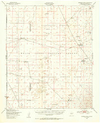
 1948 Malpais Well1954 Print · USGSThe high-desert ranching country of Socorro and Sierra counties is captured here just after the war. Researchers can trace the legacy of the Pedro Armendaris Grant No 33 and locate historic outposts like Casa Grande Ranch and Malpais Well.
 - 1948 Map of Mockingbird Gap, 1955 Print
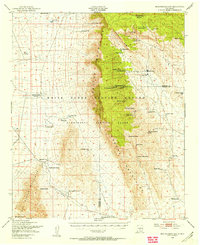 1948 Mockingbird Gap1955 Print · USGSHigh-desert ranching meets Cold War military testing in this late 1940s survey of the Oscura Mountains. Researchers can trace remote outposts like A D Helm Ranch and Estes City alongside early installations for the White Sands Proving Ground.2 unique versions available
 - 1948 Map of Salinas Peak, 1955 Print
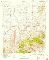 1948 Salinas Peak1955 Print · USGSThe high desert of Socorro and Sierra Counties is shown here in the late forties, just as military testing grounds began to redefine the landscape. Genealogists and researchers can trace ranching footprints like Cain Ranch Headquarters and Martin Headquarters or locate the Bear Den Sch.2 unique versions available
End of results
Showing maps 1-11 of 11
Top cities of Socorro County
Frequently asked questions
- What are the different types of historical maps available for Socorro County?
- What is the oldest map of Socorro County?
- Where can I purchase historical maps of Socorro County for my home or office?
- Where can I download high-res historical maps of Socorro County?
- Are there historical topographic maps available for Socorro County?
- Is there historical aerial imagery available for Socorro County?
- Where are historical maps of Socorro County sourced from?